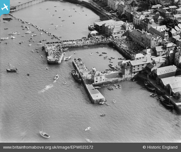
EPW023172 ENGLAND (1928). The Town Quay and North Quay, Falmouth, 1928
© Copyright OpenStreetMap contributors and licensed by the OpenStreetMap Foundation. 2026. Cartography is licensed as CC BY-SA.
Nearby Images (14)
Details
| Title | [EPW023172] The Town Quay and North Quay, Falmouth, 1928 |
| Reference | EPW023172 |
| Date | 1-September-1928 |
| Link | |
| Place name | FALMOUTH |
| Parish | FALMOUTH |
| District | |
| Country | ENGLAND |
| Easting / Northing | 181120, 32604 |
| Longitude / Latitude | -5.0643714846745, 50.152395479036 |
| National Grid Reference | SW811326 |
Pins

rivermersey |
Monday 20th of July 2020 06:27:33 PM | |

John W |
Thursday 4th of August 2016 06:28:41 PM | |

MB |
Saturday 27th of October 2012 06:00:15 PM | |

MB |
Saturday 27th of October 2012 05:58:44 PM | |

MB |
Saturday 27th of October 2012 05:57:06 PM | |
Painted in the colours of Benney & co ie; grey hull, black upper works,funnel black over red over white Could this be the "New Resolute" |

pullacross |
Tuesday 23rd of September 2014 03:16:09 AM |
User Comment Contributions
The buildings around the hipped roof are now Trago Mills, the unique 'bargain' shop in Falmouth |

Keith |
Tuesday 11th of December 2012 11:21:39 AM |


![[EPW023172] The Town Quay and North Quay, Falmouth, 1928](http://britainfromabove.org.uk/sites/all/libraries/aerofilms-images/public/100x100/EPW/023/EPW023172.jpg)
![[EPW023179] The Town Quay and North Quay, Falmouth, 1928](http://britainfromabove.org.uk/sites/all/libraries/aerofilms-images/public/100x100/EPW/023/EPW023179.jpg)
![[EPW023181] The Town Quay and North Quay, Falmouth, 1928](http://britainfromabove.org.uk/sites/all/libraries/aerofilms-images/public/100x100/EPW/023/EPW023181.jpg)
![[EPW023173] The Town Quay, Falmouth, 1928](http://britainfromabove.org.uk/sites/all/libraries/aerofilms-images/public/100x100/EPW/023/EPW023173.jpg)
![[EPW023183] The Town Quay, Falmouth, 1928](http://britainfromabove.org.uk/sites/all/libraries/aerofilms-images/public/100x100/EPW/023/EPW023183.jpg)
![[EPW023184] The Town Quay, Falmouth, 1928](http://britainfromabove.org.uk/sites/all/libraries/aerofilms-images/public/100x100/EPW/023/EPW023184.jpg)
![[EPW023174] The Town Quay, Falmouth, 1928](http://britainfromabove.org.uk/sites/all/libraries/aerofilms-images/public/100x100/EPW/023/EPW023174.jpg)
![[EPW023180] The Town Quay, Falmouth, 1928](http://britainfromabove.org.uk/sites/all/libraries/aerofilms-images/public/100x100/EPW/023/EPW023180.jpg)
![[EPW023175] The Town Quay, Falmouth, 1928](http://britainfromabove.org.uk/sites/all/libraries/aerofilms-images/public/100x100/EPW/023/EPW023175.jpg)
![[EPW023182] The Town Quay, Falmouth, 1928](http://britainfromabove.org.uk/sites/all/libraries/aerofilms-images/public/100x100/EPW/023/EPW023182.jpg)
![[EPW023185] The Town Quay, Falmouth, 1928](http://britainfromabove.org.uk/sites/all/libraries/aerofilms-images/public/100x100/EPW/023/EPW023185.jpg)
![[EPW023177] The Town Quay, Falmouth, 1928](http://britainfromabove.org.uk/sites/all/libraries/aerofilms-images/public/100x100/EPW/023/EPW023177.jpg)
![[EPW023178] The Town Quay and Arwenack Street, Falmouth, 1928](http://britainfromabove.org.uk/sites/all/libraries/aerofilms-images/public/100x100/EPW/023/EPW023178.jpg)
![[EPW021723] Wodehouse Terrace, the Town Dock and environs, Falmouth, 1928](http://britainfromabove.org.uk/sites/all/libraries/aerofilms-images/public/100x100/EPW/021/EPW021723.jpg)