
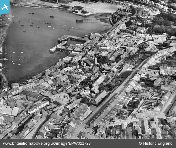
EPW021723 ENGLAND (1928). Wodehouse Terrace, the Town Dock and environs, Falmouth, 1928
© Copyright OpenStreetMap contributors and licensed by the OpenStreetMap Foundation. 2026. Cartography is licensed as CC BY-SA.
Nearby Images (14)
EPW021723

EPW023172

EPW023175

EPW023179

EPW023183

EPW023184

EPW023182

EPW023173

EPW023181

EPW023180

EPW023174

EPW023185

EPW023177

EPW023178

Details
| Title | [EPW021723] Wodehouse Terrace, the Town Dock and environs, Falmouth, 1928 |
| Reference | EPW021723 |
| Date | 24-June-1928 |
| Link | |
| Place name | FALMOUTH |
| Parish | FALMOUTH |
| District | |
| Country | ENGLAND |
| Easting / Northing | 180934, 32636 |
| Longitude / Latitude | -5.0669899761944, 50.152614200342 |
| National Grid Reference | SW809326 |
Pins

matthewfox |
Wednesday 17th of January 2024 09:23:51 PM | |
|
matthewfox |
Wednesday 17th of January 2024 09:23:38 PM | |
|
matthewfox |
Wednesday 17th of January 2024 09:22:47 PM | |
|
matthewfox |
Wednesday 17th of January 2024 09:22:33 PM | |
|
Tony Piper |
Saturday 15th of June 2013 06:04:49 PM | |
|
Tony Piper |
Saturday 15th of June 2013 06:02:58 PM |
User Comment Contributions
Custom House Quay, Falmouth, 26/06/2007 |

Class31 |
Saturday 13th of June 2015 07:33:27 AM |