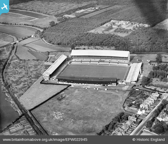
EPW022945 ENGLAND (1928). Twickenham Rugby Football Ground, Twickenham, 1928
© Copyright OpenStreetMap contributors and licensed by the OpenStreetMap Foundation. 2026. Cartography is licensed as CC BY-SA.
Nearby Images (22)
Details
| Title | [EPW022945] Twickenham Rugby Football Ground, Twickenham, 1928 |
| Reference | EPW022945 |
| Date | August-1928 |
| Link | |
| Place name | TWICKENHAM |
| Parish | |
| District | |
| Country | ENGLAND |
| Easting / Northing | 515332, 174343 |
| Longitude / Latitude | -0.33985421566109, 51.455815041345 |
| National Grid Reference | TQ153743 |
Pins

mogden1 |
Wednesday 14th of February 2018 02:22:29 PM | |

mogden1 |
Wednesday 14th of February 2018 02:21:00 PM | |

Neil GS |
Monday 10th of August 2015 05:18:40 PM | |

MB |
Thursday 25th of October 2012 11:28:24 PM | |

MB |
Thursday 25th of October 2012 11:21:49 PM | |

MB |
Thursday 25th of October 2012 11:19:22 PM | |

MB |
Thursday 25th of October 2012 11:18:55 PM | |

MB |
Thursday 25th of October 2012 11:13:32 PM | |

botogol |
Thursday 28th of June 2012 09:43:11 AM | |
My friend who lived in Chudleigh Road (in the shadow of Twickenham) suggests it was a hospital originally for soldiers affected by mustard gas in WW1, it then became a TB sanatorium.The nearby forest disappeared in the 1950's. |

McWhirter |
Saturday 7th of July 2012 09:52:55 AM |
User Comment Contributions
@ botogol... It is "Mogden Isolation Hospital". Opened in 1897 it was renamed in 1938 to "South Middlesex Fever Hospital" and then in 1948 it was renamed "South Middlesex Hospital". It closed in 1991. This is now the site of Tescos. |

DepotCat |
Thursday 5th of July 2012 11:39:55 AM |


![[EPW022945] Twickenham Rugby Football Ground, Twickenham, 1928](http://britainfromabove.org.uk/sites/all/libraries/aerofilms-images/public/100x100/EPW/022/EPW022945.jpg)
![[EPW025841] Twickenham, the annual Army Navy rugby union match, 1929](http://britainfromabove.org.uk/sites/all/libraries/aerofilms-images/public/100x100/EPW/025/EPW025841.jpg)
![[EPW025840] Twickenham, the annual Army Navy rugby union match, 1929](http://britainfromabove.org.uk/sites/all/libraries/aerofilms-images/public/100x100/EPW/025/EPW025840.jpg)
![[EPW025843] Twickenham, the annual Army Navy rugby union match, 1929](http://britainfromabove.org.uk/sites/all/libraries/aerofilms-images/public/100x100/EPW/025/EPW025843.jpg)
![[EPW049455] Twickenham Rugby Football Ground, Twickenham, 1935](http://britainfromabove.org.uk/sites/all/libraries/aerofilms-images/public/100x100/EPW/049/EPW049455.jpg)
![[EPW049454] Twickenham Rugby Football Ground, Twickenham, 1935](http://britainfromabove.org.uk/sites/all/libraries/aerofilms-images/public/100x100/EPW/049/EPW049454.jpg)
![[EPW049447] Twickenham Rugby Football Ground, Twickenham, 1935](http://britainfromabove.org.uk/sites/all/libraries/aerofilms-images/public/100x100/EPW/049/EPW049447.jpg)
![[EPW025839] Twickenham, the annual Army Navy rugby union match, 1929](http://britainfromabove.org.uk/sites/all/libraries/aerofilms-images/public/100x100/EPW/025/EPW025839.jpg)
![[EPW049453] Twickenham Rugby Football Ground, Twickenham, 1935](http://britainfromabove.org.uk/sites/all/libraries/aerofilms-images/public/100x100/EPW/049/EPW049453.jpg)
![[EPR000638] Twickenham Rugby Football Ground, Twickenham, 1935](http://britainfromabove.org.uk/sites/all/libraries/aerofilms-images/public/100x100/EPR/000/EPR000638.jpg)
![[EPW025842] Twickenham, the annual Army Navy rugby union match, 1929](http://britainfromabove.org.uk/sites/all/libraries/aerofilms-images/public/100x100/EPW/025/EPW025842.jpg)
![[EPW049446] Twickenham Rugby Football Ground, Twickenham, 1935](http://britainfromabove.org.uk/sites/all/libraries/aerofilms-images/public/100x100/EPW/049/EPW049446.jpg)
![[EPW023249] Twickenham Rugby Stadium, Twickenham, 1928](http://britainfromabove.org.uk/sites/all/libraries/aerofilms-images/public/100x100/EPW/023/EPW023249.jpg)
![[EPW049452] Twickenham Rugby Football Ground, Twickenham, 1935](http://britainfromabove.org.uk/sites/all/libraries/aerofilms-images/public/100x100/EPW/049/EPW049452.jpg)
![[EPW025845] Twickenham, the annual Army Navy rugby union match, 1929](http://britainfromabove.org.uk/sites/all/libraries/aerofilms-images/public/100x100/EPW/025/EPW025845.jpg)
![[EPW025844] Twickenham, the annual Army Navy rugby union match, 1929](http://britainfromabove.org.uk/sites/all/libraries/aerofilms-images/public/100x100/EPW/025/EPW025844.jpg)
![[EPW049449] Twickenham Rugby Football Ground, Twickenham, 1935](http://britainfromabove.org.uk/sites/all/libraries/aerofilms-images/public/100x100/EPW/049/EPW049449.jpg)
![[EPW017385] Twickenham Rugby Football Ground, Twickenham, 1927](http://britainfromabove.org.uk/sites/all/libraries/aerofilms-images/public/100x100/EPW/017/EPW017385.jpg)
![[EPW049451] Twickenham Rugby Football Ground, Twickenham, 1935](http://britainfromabove.org.uk/sites/all/libraries/aerofilms-images/public/100x100/EPW/049/EPW049451.jpg)
![[EPW049450] Twickenham Rugby Football Ground and environs, Twickenham, from the south, 1935](http://britainfromabove.org.uk/sites/all/libraries/aerofilms-images/public/100x100/EPW/049/EPW049450.jpg)
![[EPW049448] Twickenham Rugby Football Ground, Twickenham, 1935](http://britainfromabove.org.uk/sites/all/libraries/aerofilms-images/public/100x100/EPW/049/EPW049448.jpg)
![[EPW034843] Twickenham Rugby Football Ground, Twickenham, 1931. This image has been produced from a damaged negative.](http://britainfromabove.org.uk/sites/all/libraries/aerofilms-images/public/100x100/EPW/034/EPW034843.jpg)