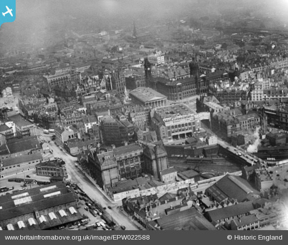
EPW022588 ENGLAND (1928). The Town Hall and environs, Birmingham, 1928
© Copyright OpenStreetMap contributors and licensed by the OpenStreetMap Foundation. 2026. Cartography is licensed as CC BY-SA.
Nearby Images (31)
EPW022588

EAW006930

EAW013564

EPW037053

EPW005845

EAW026251

EPW005839

EPW005854

EAW013566

EPW005850

EPW054232

EPW054234

EAW026250

EPW005836

EPW022585

EAW026253

EPW037056

EPW022584

EPW005851

EPW001136

EPW005835

EAW001234

EPW057482

EAW013565

EPW005853

EPW038600

EPW037054

EPW048092

EPW038602

EPW005843

EPW041475

Details
| Title | [EPW022588] The Town Hall and environs, Birmingham, 1928 |
| Reference | EPW022588 |
| Date | 7-August-1928 |
| Link | |
| Place name | BIRMINGHAM |
| Parish | |
| District | |
| Country | ENGLAND |
| Easting / Northing | 406640, 286779 |
| Longitude / Latitude | -1.9022229470071, 52.478527941006 |
| National Grid Reference | SP066868 |
Pins

Griffin |
Sunday 9th of February 2020 07:51:14 PM | |
|
Griffin |
Friday 16th of October 2015 07:27:28 PM | |
|
Griffin |
Friday 16th of October 2015 07:25:35 PM | |
|
Griffin |
Friday 16th of October 2015 07:24:11 PM | |
|
Griffin |
Friday 16th of October 2015 07:22:15 PM | |
|
Steve Cemm |
Tuesday 10th of July 2012 09:40:18 PM | |
|
Steve Cemm |
Tuesday 10th of July 2012 09:39:38 PM | |
|
Steve Cemm |
Tuesday 10th of July 2012 09:39:06 PM | |
|
Mr Pastry |
Tuesday 3rd of July 2012 03:23:55 PM | |

Brasspot |
Tuesday 26th of June 2012 10:14:12 PM |