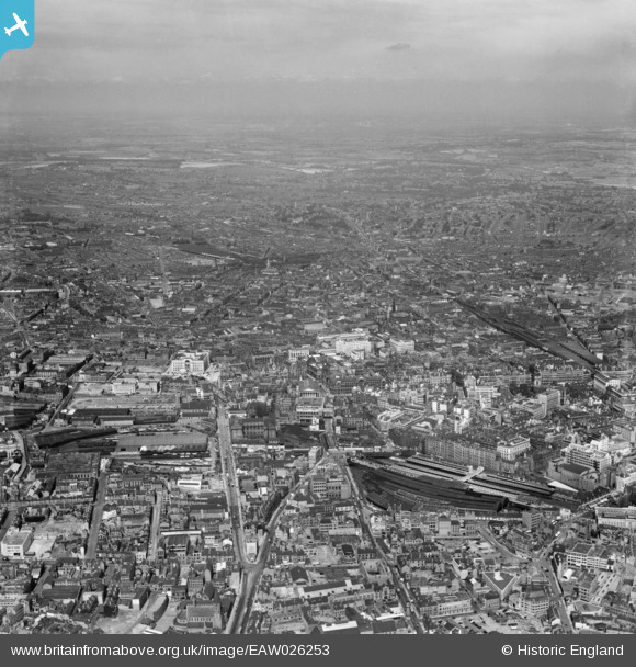
EAW026253 ENGLAND (1949). New Street Station and the city centre, Birmingham, from the south-east, 1949
© Copyright OpenStreetMap contributors and licensed by the OpenStreetMap Foundation. 2026. Cartography is licensed as CC BY-SA.
Nearby Images (28)
Details
| Title | [EAW026253] New Street Station and the city centre, Birmingham, from the south-east, 1949 |
| Reference | EAW026253 |
| Date | 13-August-1949 |
| Link | |
| Place name | BIRMINGHAM |
| Parish | |
| District | |
| Country | ENGLAND |
| Easting / Northing | 406766, 286670 |
| Longitude / Latitude | -1.9003697557108, 52.477546374455 |
| National Grid Reference | SP068867 |
Pins

Graham |
Sunday 23rd of August 2020 11:53:06 AM | |

aajhiggs |
Thursday 26th of December 2013 10:55:07 PM | |

aajhiggs |
Thursday 26th of December 2013 10:35:57 PM | |

aajhiggs |
Thursday 26th of December 2013 10:32:15 PM | |

aajhiggs |
Thursday 26th of December 2013 10:29:08 PM |


![[EAW026253] New Street Station and the city centre, Birmingham, from the south-east, 1949](http://britainfromabove.org.uk/sites/all/libraries/aerofilms-images/public/100x100/EAW/026/EAW026253.jpg)
![[EPW001136] Birmingham New Street Station and town centre, Birmingham, 1920](http://britainfromabove.org.uk/sites/all/libraries/aerofilms-images/public/100x100/EPW/001/EPW001136.jpg)
![[EPW057482] New Street Station and environs, Birmingham, 1938](http://britainfromabove.org.uk/sites/all/libraries/aerofilms-images/public/100x100/EPW/057/EPW057482.jpg)
![[EPW054232] The city centre, Birmingham, 1937](http://britainfromabove.org.uk/sites/all/libraries/aerofilms-images/public/100x100/EPW/054/EPW054232.jpg)
![[EPW041475] New Street Station and environs, Birmingham, from the south-east, 1933](http://britainfromabove.org.uk/sites/all/libraries/aerofilms-images/public/100x100/EPW/041/EPW041475.jpg)
![[EAW006930] New Street Railway Station and the city centre, Birmingham, 1947](http://britainfromabove.org.uk/sites/all/libraries/aerofilms-images/public/100x100/EAW/006/EAW006930.jpg)
![[EPW022586] New Street Railway Station, Birmingham, 1928](http://britainfromabove.org.uk/sites/all/libraries/aerofilms-images/public/100x100/EPW/022/EPW022586.jpg)
![[EAW026252] New Street Station and the city centre, Birmingham, from the south-west, 1949](http://britainfromabove.org.uk/sites/all/libraries/aerofilms-images/public/100x100/EAW/026/EAW026252.jpg)
![[EPW022588] The Town Hall and environs, Birmingham, 1928](http://britainfromabove.org.uk/sites/all/libraries/aerofilms-images/public/100x100/EPW/022/EPW022588.jpg)
![[EPW005840] Birmingham New Street Station, Birmingham, 1921](http://britainfromabove.org.uk/sites/all/libraries/aerofilms-images/public/100x100/EPW/005/EPW005840.jpg)
![[EPW037053] Victoria Square and the city centre, Birmingham, 1931](http://britainfromabove.org.uk/sites/all/libraries/aerofilms-images/public/100x100/EPW/037/EPW037053.jpg)
![[EPW038601] New Street Station, Birmingham, 1932](http://britainfromabove.org.uk/sites/all/libraries/aerofilms-images/public/100x100/EPW/038/EPW038601.jpg)
![[EPW058129] New Street Station, Birmingham, 1938](http://britainfromabove.org.uk/sites/all/libraries/aerofilms-images/public/100x100/EPW/058/EPW058129.jpg)
![[EAW035108] New Street Station and environs, Birmingham, 1951](http://britainfromabove.org.uk/sites/all/libraries/aerofilms-images/public/100x100/EAW/035/EAW035108.jpg)
![[EAW001234] New Street Railway Station and the city centre, Birmingham, 1946](http://britainfromabove.org.uk/sites/all/libraries/aerofilms-images/public/100x100/EAW/001/EAW001234.jpg)
![[EPW054234] The city centre, Birmingham, from the south-east, 1937](http://britainfromabove.org.uk/sites/all/libraries/aerofilms-images/public/100x100/EPW/054/EPW054234.jpg)
![[EAW001237] New Street Railway Station, the Town Hall and the city centre, Birmingham, 1946](http://britainfromabove.org.uk/sites/all/libraries/aerofilms-images/public/100x100/EAW/001/EAW001237.jpg)
![[EAW013564] The city centre including the Hall of Memory, New Street Station and St Philip's Cathedral, Birmingham, from the south-west, 1948](http://britainfromabove.org.uk/sites/all/libraries/aerofilms-images/public/100x100/EAW/013/EAW013564.jpg)
![[EPW005835] The Town Hall, New Street and environs, Birmingham, 1921. This image has been produced from a print.](http://britainfromabove.org.uk/sites/all/libraries/aerofilms-images/public/100x100/EPW/005/EPW005835.jpg)
![[EPW005845] The Town Hall and Council House on Victoria Square, Birmingham, 1921](http://britainfromabove.org.uk/sites/all/libraries/aerofilms-images/public/100x100/EPW/005/EPW005845.jpg)
![[EAW013566] The city centre including Victoria Square and Snow Hill Station, Birmingham, 1948](http://britainfromabove.org.uk/sites/all/libraries/aerofilms-images/public/100x100/EAW/013/EAW013566.jpg)
![[EAW001235] New Street and Snow Hill Railway Stations and the city centre, Birmingham, 1946](http://britainfromabove.org.uk/sites/all/libraries/aerofilms-images/public/100x100/EAW/001/EAW001235.jpg)
![[EPW005839] The Library, Town Hall and environs, Birmingham, 1921. This image has been produced from a print.](http://britainfromabove.org.uk/sites/all/libraries/aerofilms-images/public/100x100/EPW/005/EPW005839.jpg)
![[EAW015327] New Street Railway Station, Smithfield Market and the city centre, Birmingham, 1948. This image has been produced from a print.](http://britainfromabove.org.uk/sites/all/libraries/aerofilms-images/public/100x100/EAW/015/EAW015327.jpg)
![[EPW005854] The Town Hall, Council House and Art Gallery, Birmingham, 1921. This image has been produced from a print.](http://britainfromabove.org.uk/sites/all/libraries/aerofilms-images/public/100x100/EPW/005/EPW005854.jpg)
![[EAW026251] Snow Hill Station and the city centre, Birmingham, from the south-west, 1949](http://britainfromabove.org.uk/sites/all/libraries/aerofilms-images/public/100x100/EAW/026/EAW026251.jpg)
![[EAW035107] Corporation Street and environs, Birmingham, 1951](http://britainfromabove.org.uk/sites/all/libraries/aerofilms-images/public/100x100/EAW/035/EAW035107.jpg)
![[EPW005850] The Town Hall on Victoria Square and environs, Birmingham, 1921. This image has been produced from a print.](http://britainfromabove.org.uk/sites/all/libraries/aerofilms-images/public/100x100/EPW/005/EPW005850.jpg)