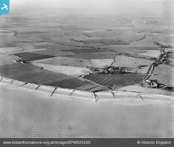
EPW020165 ENGLAND (1927). Bailiffscourt and surrounding countryside, Climping, 1927
© Copyright OpenStreetMap contributors and licensed by the OpenStreetMap Foundation. 2026. Cartography is licensed as CC BY-SA.
Nearby Images (36)
Details
| Title | [EPW020165] Bailiffscourt and surrounding countryside, Climping, 1927 |
| Reference | EPW020165 |
| Date | 26-November-1927 |
| Link | |
| Place name | CLIMPING |
| Parish | CLIMPING |
| District | |
| Country | ENGLAND |
| Easting / Northing | 500129, 100834 |
| Longitude / Latitude | -0.57904277421873, 50.797843018387 |
| National Grid Reference | TQ001008 |
Pins

MB |
Saturday 13th of October 2012 01:43:53 PM | |

MB |
Saturday 13th of October 2012 01:42:59 PM | |

MB |
Saturday 13th of October 2012 01:41:12 PM | |

MB |
Saturday 13th of October 2012 01:40:17 PM | |

MB |
Saturday 13th of October 2012 01:35:41 PM | |

MB |
Saturday 13th of October 2012 01:33:02 PM | |

MB |
Saturday 13th of October 2012 01:31:59 PM | |

MB |
Saturday 13th of October 2012 01:30:20 PM |


![[EPW020165] Bailiffscourt and surrounding countryside, Climping, 1927](http://britainfromabove.org.uk/sites/all/libraries/aerofilms-images/public/100x100/EPW/020/EPW020165.jpg)
![[EPW020155] Bailiffscourt and surrounding countryside, Climping, 1927](http://britainfromabove.org.uk/sites/all/libraries/aerofilms-images/public/100x100/EPW/020/EPW020155.jpg)
![[EPW062498] Bailiffscourt and the surrounding countryside, Climping, 1939](http://britainfromabove.org.uk/sites/all/libraries/aerofilms-images/public/100x100/EPW/062/EPW062498.jpg)
![[EPW020167] Bailiffscourt and surrounding countryside, Climping, 1927](http://britainfromabove.org.uk/sites/all/libraries/aerofilms-images/public/100x100/EPW/020/EPW020167.jpg)
![[EPW020160] Bailiffscourt and surrounding countryside, Climping, 1927](http://britainfromabove.org.uk/sites/all/libraries/aerofilms-images/public/100x100/EPW/020/EPW020160.jpg)
![[EPW020171] Bailiffscourt, Climping, 1927](http://britainfromabove.org.uk/sites/all/libraries/aerofilms-images/public/100x100/EPW/020/EPW020171.jpg)
![[EPW062495] Bailiffscourt, Climping, 1939](http://britainfromabove.org.uk/sites/all/libraries/aerofilms-images/public/100x100/EPW/062/EPW062495.jpg)
![[EPW020169] Bailiffscourt and surrounding countryside, Climping, 1927](http://britainfromabove.org.uk/sites/all/libraries/aerofilms-images/public/100x100/EPW/020/EPW020169.jpg)
![[EPW062494] Bailiffscourt, Climping, 1939](http://britainfromabove.org.uk/sites/all/libraries/aerofilms-images/public/100x100/EPW/062/EPW062494.jpg)
![[EPW020153] Bailiffscourt, Climping, 1927](http://britainfromabove.org.uk/sites/all/libraries/aerofilms-images/public/100x100/EPW/020/EPW020153.jpg)
![[EPW062497] Bailiffscourt and the surrounding countryside, Climping, 1939](http://britainfromabove.org.uk/sites/all/libraries/aerofilms-images/public/100x100/EPW/062/EPW062497.jpg)
![[EPW045538] Bailiffscourt and surrounding countryside, Atherington, 1934. This image has been produced from a damaged negative.](http://britainfromabove.org.uk/sites/all/libraries/aerofilms-images/public/100x100/EPW/045/EPW045538.jpg)
![[EPW020148] Bailiffscourt and surrounding countryside, Climping, 1927](http://britainfromabove.org.uk/sites/all/libraries/aerofilms-images/public/100x100/EPW/020/EPW020148.jpg)
![[EPW020156] Bailiffscourt, Climping, 1927](http://britainfromabove.org.uk/sites/all/libraries/aerofilms-images/public/100x100/EPW/020/EPW020156.jpg)
![[EPW020162] Bailiffscourt, Climping, 1927](http://britainfromabove.org.uk/sites/all/libraries/aerofilms-images/public/100x100/EPW/020/EPW020162.jpg)
![[EPW020164] Bailiffscourt and surrounding countryside, Climping, 1927](http://britainfromabove.org.uk/sites/all/libraries/aerofilms-images/public/100x100/EPW/020/EPW020164.jpg)
![[EPW045536] Bailiffscourt, Atherington, 1934. This image has been produced from a damaged negative.](http://britainfromabove.org.uk/sites/all/libraries/aerofilms-images/public/100x100/EPW/045/EPW045536.jpg)
![[EPW062492] Bailiffscourt, Climping, 1939](http://britainfromabove.org.uk/sites/all/libraries/aerofilms-images/public/100x100/EPW/062/EPW062492.jpg)
![[EPW020149] Bailiffscourt and surrounding countryside, Climping, 1927](http://britainfromabove.org.uk/sites/all/libraries/aerofilms-images/public/100x100/EPW/020/EPW020149.jpg)
![[EPW020150] Bailiffscourt, Climping, 1927](http://britainfromabove.org.uk/sites/all/libraries/aerofilms-images/public/100x100/EPW/020/EPW020150.jpg)
![[EPW020151] Bailiffscourt, Climping, 1927](http://britainfromabove.org.uk/sites/all/libraries/aerofilms-images/public/100x100/EPW/020/EPW020151.jpg)
![[EPW020157] Bailiffscourt, Climping, 1927](http://britainfromabove.org.uk/sites/all/libraries/aerofilms-images/public/100x100/EPW/020/EPW020157.jpg)
![[EPW062503] Bailiffscourt and the surrounding coastline, Climping, from the west, 1939](http://britainfromabove.org.uk/sites/all/libraries/aerofilms-images/public/100x100/EPW/062/EPW062503.jpg)
![[EPW020152] Bailiffscourt, Climping, 1927](http://britainfromabove.org.uk/sites/all/libraries/aerofilms-images/public/100x100/EPW/020/EPW020152.jpg)
![[EPW020158] Bailiffscourt, Climping, 1927](http://britainfromabove.org.uk/sites/all/libraries/aerofilms-images/public/100x100/EPW/020/EPW020158.jpg)
![[EPW020172] Bailiffscourt, Climping, 1927](http://britainfromabove.org.uk/sites/all/libraries/aerofilms-images/public/100x100/EPW/020/EPW020172.jpg)
![[EPW020170] Bailiffscourt, Climping, 1927](http://britainfromabove.org.uk/sites/all/libraries/aerofilms-images/public/100x100/EPW/020/EPW020170.jpg)
![[EPW045583] Bailiffscourt and environs, Atherington, 1934. This image has been produced from a damaged negative.](http://britainfromabove.org.uk/sites/all/libraries/aerofilms-images/public/100x100/EPW/045/EPW045583.jpg)
![[EPW020163] Bailiffscourt and the sea, Climping, 1927](http://britainfromabove.org.uk/sites/all/libraries/aerofilms-images/public/100x100/EPW/020/EPW020163.jpg)
![[EPW045537] Bailiffscourt and surrounding countryside, Atherington, 1934. This image has been produced from a damaged negative.](http://britainfromabove.org.uk/sites/all/libraries/aerofilms-images/public/100x100/EPW/045/EPW045537.jpg)
![[EPW045533] The beach, Bailiffscourt and surrounding countryside, Atherington, from the south, 1934. This image has been produced from a damaged negative.](http://britainfromabove.org.uk/sites/all/libraries/aerofilms-images/public/100x100/EPW/045/EPW045533.jpg)
![[EPW020161] Bailiffscourt, Climping, 1927](http://britainfromabove.org.uk/sites/all/libraries/aerofilms-images/public/100x100/EPW/020/EPW020161.jpg)
![[EPW062504] Bailiffscourt and the surrounding coastline, Climping, 1939](http://britainfromabove.org.uk/sites/all/libraries/aerofilms-images/public/100x100/EPW/062/EPW062504.jpg)
![[EPW062493] Bailiffscourt, Climping, from the north-west, 1939](http://britainfromabove.org.uk/sites/all/libraries/aerofilms-images/public/100x100/EPW/062/EPW062493.jpg)
![[EPW045531] The beach, Atherington, Bailiffscourt and surrounding countryside, Atherington, from the south-east, 1934. This image has been produced from a damaged negative.](http://britainfromabove.org.uk/sites/all/libraries/aerofilms-images/public/100x100/EPW/045/EPW045531.jpg)
![[EPW045535] The beach, Cudlow Barn, Bailiffscourt and surrounding countryside, Atherington, from the south-west, 1934. This image has been produced from a damaged negative.](http://britainfromabove.org.uk/sites/all/libraries/aerofilms-images/public/100x100/EPW/045/EPW045535.jpg)