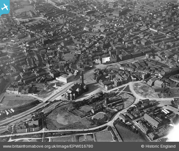
EPW016780 ENGLAND (1926). The town hall and environs, Rochdale, 1926
© Copyright OpenStreetMap contributors and licensed by the OpenStreetMap Foundation. 2025. Cartography is licensed as CC BY-SA.
Nearby Images (6)
Details
| Title | [EPW016780] The town hall and environs, Rochdale, 1926 |
| Reference | EPW016780 |
| Date | August-1926 |
| Link | |
| Place name | ROCHDALE |
| Parish | |
| District | |
| Country | ENGLAND |
| Easting / Northing | 389645, 413389 |
| Longitude / Latitude | -2.1565528327992, 53.616708352398 |
| National Grid Reference | SD896134 |
Pins

JParr76 |
Monday 14th of July 2025 04:14:33 PM | |

JParr76 |
Monday 14th of July 2025 04:14:00 PM | |

JParr76 |
Monday 14th of July 2025 04:13:13 PM | |

JParr76 |
Monday 14th of July 2025 04:12:45 PM | |

JParr76 |
Monday 14th of July 2025 04:11:31 PM | |

JParr76 |
Monday 14th of July 2025 04:10:56 PM | |

JParr76 |
Monday 14th of July 2025 04:10:39 PM | |

JParr76 |
Monday 14th of July 2025 04:09:56 PM | |

JParr76 |
Monday 14th of July 2025 04:09:29 PM | |

JParr76 |
Monday 14th of July 2025 04:09:04 PM | |

JParr76 |
Monday 14th of July 2025 04:08:42 PM | |

JParr76 |
Monday 14th of July 2025 04:08:03 PM | |

JParr76 |
Monday 14th of July 2025 04:07:31 PM | |

JParr76 |
Monday 14th of July 2025 04:06:51 PM | |

Ian WASHG |
Friday 1st of April 2022 06:28:42 AM | |

Ian WASHG |
Friday 1st of April 2022 06:22:18 AM | |

5485paul |
Friday 15th of December 2017 08:58:01 AM | |

Mikeya |
Sunday 6th of April 2014 11:24:41 AM | |

Mikeya |
Sunday 6th of April 2014 11:23:39 AM | |

Mikeya |
Sunday 6th of April 2014 11:20:59 AM | |

Mikeya |
Sunday 6th of April 2014 11:20:28 AM | |

Mikeya |
Sunday 6th of April 2014 11:18:45 AM | |

Mikeya |
Sunday 6th of April 2014 11:17:56 AM |


![[EPW016780] The town hall and environs, Rochdale, 1926](http://britainfromabove.org.uk/sites/all/libraries/aerofilms-images/public/100x100/EPW/016/EPW016780.jpg)
![[EPW016786] The town hall and St Chad's Church, Rochdale, 1926](http://britainfromabove.org.uk/sites/all/libraries/aerofilms-images/public/100x100/EPW/016/EPW016786.jpg)
![[EPW016783] Town Hall Square, Rochdale, 1926](http://britainfromabove.org.uk/sites/all/libraries/aerofilms-images/public/100x100/EPW/016/EPW016783.jpg)
![[EPW016797] St Chad's Church and Gardens and environs, Rochdale, 1926](http://britainfromabove.org.uk/sites/all/libraries/aerofilms-images/public/100x100/EPW/016/EPW016797.jpg)
![[EPW016791] Town Hall Square, Rochdale, 1926](http://britainfromabove.org.uk/sites/all/libraries/aerofilms-images/public/100x100/EPW/016/EPW016791.jpg)
![[EAW022017] The town centre, Rochdale, from the north-west, 1949](http://britainfromabove.org.uk/sites/all/libraries/aerofilms-images/public/100x100/EAW/022/EAW022017.jpg)