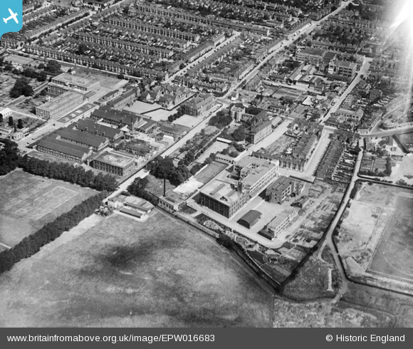
EPW016683 ENGLAND (1926). The Caribonum Factory and London Electric Wire Company Works, Leyton, 1926
© Copyright OpenStreetMap contributors and licensed by the OpenStreetMap Foundation. 2026. Cartography is licensed as CC BY-SA.
Nearby Images (29)
Details
| Title | [EPW016683] The Caribonum Factory and London Electric Wire Company Works, Leyton, 1926 |
| Reference | EPW016683 |
| Date | August-1926 |
| Link | |
| Place name | LEYTON |
| Parish | |
| District | |
| Country | ENGLAND |
| Easting / Northing | 537163, 186950 |
| Longitude / Latitude | -0.020888050528436, 51.564247080667 |
| National Grid Reference | TQ372870 |
Pins

Chingford |
Thursday 27th of October 2022 03:10:07 PM | |

Chingford |
Thursday 27th of October 2022 11:56:02 AM | |

Hermann the German |
Monday 28th of October 2013 02:29:00 PM | |

Hermann the German |
Monday 28th of October 2013 02:28:07 PM | |

Hermann the German |
Monday 28th of October 2013 02:27:19 PM | |

Hermann the German |
Monday 28th of October 2013 02:26:38 PM | |

Hermann the German |
Monday 28th of October 2013 02:24:52 PM |


![[EPW016683] The Caribonum Factory and London Electric Wire Company Works, Leyton, 1926](http://britainfromabove.org.uk/sites/all/libraries/aerofilms-images/public/100x100/EPW/016/EPW016683.jpg)
![[EPW008519] The Caribonum Works, Electric Wire Works and environs, Leyton, 1923](http://britainfromabove.org.uk/sites/all/libraries/aerofilms-images/public/100x100/EPW/008/EPW008519.jpg)
![[EPW008352] The Caribonum Factory and Electric Wire Works and environs, Leyton, 1923](http://britainfromabove.org.uk/sites/all/libraries/aerofilms-images/public/100x100/EPW/008/EPW008352.jpg)
![[EPW016684] The Caribonum Factory, Leyton, 1926](http://britainfromabove.org.uk/sites/all/libraries/aerofilms-images/public/100x100/EPW/016/EPW016684.jpg)
![[EPW016685] The Caribonum Factory and London Electric Wire Company Works, Leyton, 1926](http://britainfromabove.org.uk/sites/all/libraries/aerofilms-images/public/100x100/EPW/016/EPW016685.jpg)
![[EPW008518] The Caribonum Works, Electric Wire Works and environs, Leyton, 1923](http://britainfromabove.org.uk/sites/all/libraries/aerofilms-images/public/100x100/EPW/008/EPW008518.jpg)
![[EPW016679] The London Electric Wire Company Works and environs, Leyton, 1926](http://britainfromabove.org.uk/sites/all/libraries/aerofilms-images/public/100x100/EPW/016/EPW016679.jpg)
![[EPW016681] The London Electric Wire Company Works and environs, Leyton, 1926](http://britainfromabove.org.uk/sites/all/libraries/aerofilms-images/public/100x100/EPW/016/EPW016681.jpg)
![[EPW016675] The London Electric Wire Company Works and environs, Leyton, 1926](http://britainfromabove.org.uk/sites/all/libraries/aerofilms-images/public/100x100/EPW/016/EPW016675.jpg)
![[EAW030518] The London Electric Wire Co and Smiths Works, Leyton, 1950. This image was marked by Aerofilms Ltd for photo editing.](http://britainfromabove.org.uk/sites/all/libraries/aerofilms-images/public/100x100/EAW/030/EAW030518.jpg)
![[EPW016676] The London Electric Wire Company Works and environs, Leyton, 1926](http://britainfromabove.org.uk/sites/all/libraries/aerofilms-images/public/100x100/EPW/016/EPW016676.jpg)
![[EPW008517] The Caribonum Works and environs, Leyton, 1923](http://britainfromabove.org.uk/sites/all/libraries/aerofilms-images/public/100x100/EPW/008/EPW008517.jpg)
![[EAW030521] The Church Road Primary Schools and the London Electric Wire Co and Smiths Works, Leyton, 1950. This image was marked by Aerofilms Ltd for photo editing.](http://britainfromabove.org.uk/sites/all/libraries/aerofilms-images/public/100x100/EAW/030/EAW030521.jpg)
![[EPW008514] The Electric Wire Works and Caribonum Works, Leyton, 1923](http://britainfromabove.org.uk/sites/all/libraries/aerofilms-images/public/100x100/EPW/008/EPW008514.jpg)
![[EPW008516] The Electric Wire Works and environs, Leyton, 1923](http://britainfromabove.org.uk/sites/all/libraries/aerofilms-images/public/100x100/EPW/008/EPW008516.jpg)
![[EAW030516] The Church Road Primary Schools and the London Electric Wire Co and Smiths Works, Leyton, 1950. This image was marked by Aerofilms Ltd for photo editing.](http://britainfromabove.org.uk/sites/all/libraries/aerofilms-images/public/100x100/EAW/030/EAW030516.jpg)
![[EPW016682] The London Electric Wire Company Works and environs, Leyton, 1926](http://britainfromabove.org.uk/sites/all/libraries/aerofilms-images/public/100x100/EPW/016/EPW016682.jpg)
![[EPW008515] The Electric Wire Works, Caribonum Works and environs, Leyton, 1923](http://britainfromabove.org.uk/sites/all/libraries/aerofilms-images/public/100x100/EPW/008/EPW008515.jpg)
![[EPW016680] The London Electric Wire Company Works and environs, Leyton, 1926](http://britainfromabove.org.uk/sites/all/libraries/aerofilms-images/public/100x100/EPW/016/EPW016680.jpg)
![[EPW008513] The Electric Wire Works, Leyton, 1923](http://britainfromabove.org.uk/sites/all/libraries/aerofilms-images/public/100x100/EPW/008/EPW008513.jpg)
![[EAW030525] The Church Road Primary Schools and the London Electric Wire Co and Smiths Works, Leyton, 1950. This image was marked by Aerofilms Ltd for photo editing.](http://britainfromabove.org.uk/sites/all/libraries/aerofilms-images/public/100x100/EAW/030/EAW030525.jpg)
![[EPW016677] The London Electric Wire Company Works and environs, Leyton, 1926](http://britainfromabove.org.uk/sites/all/libraries/aerofilms-images/public/100x100/EPW/016/EPW016677.jpg)
![[EAW030520] The Church Road Primary Schools and the London Electric Wire Co and Smiths Works, Leyton, 1950. This image was marked by Aerofilms Ltd for photo editing.](http://britainfromabove.org.uk/sites/all/libraries/aerofilms-images/public/100x100/EAW/030/EAW030520.jpg)
![[EAW030524] The Church Road Primary Schools and the London Electric Wire Co and Smiths Works, Leyton, 1950. This image was marked by Aerofilms Ltd for photo editing.](http://britainfromabove.org.uk/sites/all/libraries/aerofilms-images/public/100x100/EAW/030/EAW030524.jpg)
![[EAW030522] The Church Road Primary Schools and the London Electric Wire Co and Smiths Works, Leyton, 1950. This image was marked by Aerofilms Ltd for photo editing.](http://britainfromabove.org.uk/sites/all/libraries/aerofilms-images/public/100x100/EAW/030/EAW030522.jpg)
![[EAW030523] The London Electric Wire Co and Smiths Works and the surrounding area, Leyton, 1950. This image was marked by Aerofilms Ltd for photo editing.](http://britainfromabove.org.uk/sites/all/libraries/aerofilms-images/public/100x100/EAW/030/EAW030523.jpg)
![[EAW030517] The London Electric Wire Co and Smiths Works, Leyton, 1950. This image was marked by Aerofilms Ltd for photo editing.](http://britainfromabove.org.uk/sites/all/libraries/aerofilms-images/public/100x100/EAW/030/EAW030517.jpg)
![[EPW008351] The Electric Wire Works and environs, Leyton, 1923](http://britainfromabove.org.uk/sites/all/libraries/aerofilms-images/public/100x100/EPW/008/EPW008351.jpg)
![[EAW030519] The London Electric Wire Co and Smiths Works, Leyton, 1950. This image was marked by Aerofilms Ltd for photo editing.](http://britainfromabove.org.uk/sites/all/libraries/aerofilms-images/public/100x100/EAW/030/EAW030519.jpg)