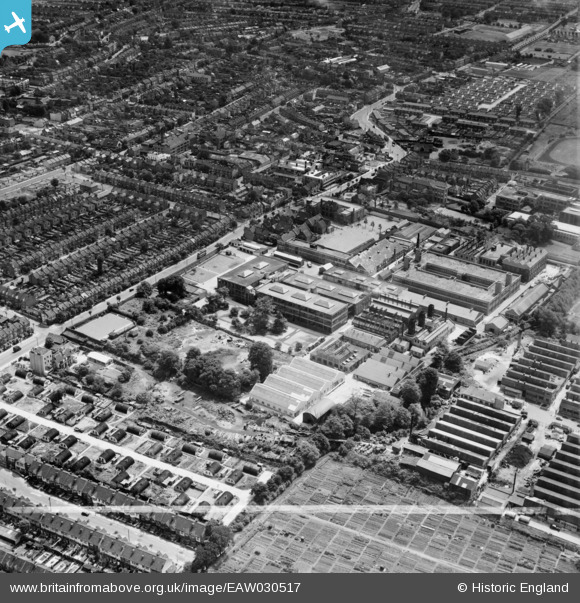
EAW030517 ENGLAND (1950). The London Electric Wire Co and Smiths Works, Leyton, 1950. This image was marked by Aerofilms Ltd for photo editing.
© Copyright OpenStreetMap contributors and licensed by the OpenStreetMap Foundation. 2026. Cartography is licensed as CC BY-SA.
Nearby Images (25)
Details
| Title | [EAW030517] The London Electric Wire Co and Smiths Works, Leyton, 1950. This image was marked by Aerofilms Ltd for photo editing. |
| Reference | EAW030517 |
| Date | 26-June-1950 |
| Link | |
| Place name | LEYTON |
| Parish | |
| District | |
| Country | ENGLAND |
| Easting / Northing | 537113, 187181 |
| Longitude / Latitude | -0.021518899205581, 51.566335247861 |
| National Grid Reference | TQ371872 |


![[EAW030517] The London Electric Wire Co and Smiths Works, Leyton, 1950. This image was marked by Aerofilms Ltd for photo editing.](http://britainfromabove.org.uk/sites/all/libraries/aerofilms-images/public/100x100/EAW/030/EAW030517.jpg)
![[EPW008351] The Electric Wire Works and environs, Leyton, 1923](http://britainfromabove.org.uk/sites/all/libraries/aerofilms-images/public/100x100/EPW/008/EPW008351.jpg)
![[EAW030519] The London Electric Wire Co and Smiths Works, Leyton, 1950. This image was marked by Aerofilms Ltd for photo editing.](http://britainfromabove.org.uk/sites/all/libraries/aerofilms-images/public/100x100/EAW/030/EAW030519.jpg)
![[EAW030523] The London Electric Wire Co and Smiths Works and the surrounding area, Leyton, 1950. This image was marked by Aerofilms Ltd for photo editing.](http://britainfromabove.org.uk/sites/all/libraries/aerofilms-images/public/100x100/EAW/030/EAW030523.jpg)
![[EAW030522] The Church Road Primary Schools and the London Electric Wire Co and Smiths Works, Leyton, 1950. This image was marked by Aerofilms Ltd for photo editing.](http://britainfromabove.org.uk/sites/all/libraries/aerofilms-images/public/100x100/EAW/030/EAW030522.jpg)
![[EAW030520] The Church Road Primary Schools and the London Electric Wire Co and Smiths Works, Leyton, 1950. This image was marked by Aerofilms Ltd for photo editing.](http://britainfromabove.org.uk/sites/all/libraries/aerofilms-images/public/100x100/EAW/030/EAW030520.jpg)
![[EPW016677] The London Electric Wire Company Works and environs, Leyton, 1926](http://britainfromabove.org.uk/sites/all/libraries/aerofilms-images/public/100x100/EPW/016/EPW016677.jpg)
![[EPW008513] The Electric Wire Works, Leyton, 1923](http://britainfromabove.org.uk/sites/all/libraries/aerofilms-images/public/100x100/EPW/008/EPW008513.jpg)
![[EAW030525] The Church Road Primary Schools and the London Electric Wire Co and Smiths Works, Leyton, 1950. This image was marked by Aerofilms Ltd for photo editing.](http://britainfromabove.org.uk/sites/all/libraries/aerofilms-images/public/100x100/EAW/030/EAW030525.jpg)
![[EPW016682] The London Electric Wire Company Works and environs, Leyton, 1926](http://britainfromabove.org.uk/sites/all/libraries/aerofilms-images/public/100x100/EPW/016/EPW016682.jpg)
![[EPW008515] The Electric Wire Works, Caribonum Works and environs, Leyton, 1923](http://britainfromabove.org.uk/sites/all/libraries/aerofilms-images/public/100x100/EPW/008/EPW008515.jpg)
![[EPW008514] The Electric Wire Works and Caribonum Works, Leyton, 1923](http://britainfromabove.org.uk/sites/all/libraries/aerofilms-images/public/100x100/EPW/008/EPW008514.jpg)
![[EAW030516] The Church Road Primary Schools and the London Electric Wire Co and Smiths Works, Leyton, 1950. This image was marked by Aerofilms Ltd for photo editing.](http://britainfromabove.org.uk/sites/all/libraries/aerofilms-images/public/100x100/EAW/030/EAW030516.jpg)
![[EAW030524] The Church Road Primary Schools and the London Electric Wire Co and Smiths Works, Leyton, 1950. This image was marked by Aerofilms Ltd for photo editing.](http://britainfromabove.org.uk/sites/all/libraries/aerofilms-images/public/100x100/EAW/030/EAW030524.jpg)
![[EPW008516] The Electric Wire Works and environs, Leyton, 1923](http://britainfromabove.org.uk/sites/all/libraries/aerofilms-images/public/100x100/EPW/008/EPW008516.jpg)
![[EAW030521] The Church Road Primary Schools and the London Electric Wire Co and Smiths Works, Leyton, 1950. This image was marked by Aerofilms Ltd for photo editing.](http://britainfromabove.org.uk/sites/all/libraries/aerofilms-images/public/100x100/EAW/030/EAW030521.jpg)
![[EPW016680] The London Electric Wire Company Works and environs, Leyton, 1926](http://britainfromabove.org.uk/sites/all/libraries/aerofilms-images/public/100x100/EPW/016/EPW016680.jpg)
![[EPW016676] The London Electric Wire Company Works and environs, Leyton, 1926](http://britainfromabove.org.uk/sites/all/libraries/aerofilms-images/public/100x100/EPW/016/EPW016676.jpg)
![[EPW016675] The London Electric Wire Company Works and environs, Leyton, 1926](http://britainfromabove.org.uk/sites/all/libraries/aerofilms-images/public/100x100/EPW/016/EPW016675.jpg)
![[EPW016681] The London Electric Wire Company Works and environs, Leyton, 1926](http://britainfromabove.org.uk/sites/all/libraries/aerofilms-images/public/100x100/EPW/016/EPW016681.jpg)
![[EPW008518] The Caribonum Works, Electric Wire Works and environs, Leyton, 1923](http://britainfromabove.org.uk/sites/all/libraries/aerofilms-images/public/100x100/EPW/008/EPW008518.jpg)
![[EAW030518] The London Electric Wire Co and Smiths Works, Leyton, 1950. This image was marked by Aerofilms Ltd for photo editing.](http://britainfromabove.org.uk/sites/all/libraries/aerofilms-images/public/100x100/EAW/030/EAW030518.jpg)
![[EPW016679] The London Electric Wire Company Works and environs, Leyton, 1926](http://britainfromabove.org.uk/sites/all/libraries/aerofilms-images/public/100x100/EPW/016/EPW016679.jpg)
![[EPW016685] The Caribonum Factory and London Electric Wire Company Works, Leyton, 1926](http://britainfromabove.org.uk/sites/all/libraries/aerofilms-images/public/100x100/EPW/016/EPW016685.jpg)
![[EPW016683] The Caribonum Factory and London Electric Wire Company Works, Leyton, 1926](http://britainfromabove.org.uk/sites/all/libraries/aerofilms-images/public/100x100/EPW/016/EPW016683.jpg)
 8-2007.JPG)