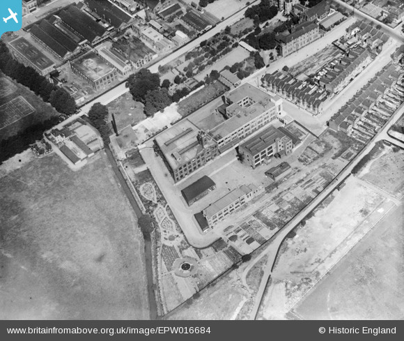
EPW016684 ENGLAND (1926). The Caribonum Factory, Leyton, 1926
© Copyright OpenStreetMap contributors and licensed by the OpenStreetMap Foundation. 2026. Cartography is licensed as CC BY-SA.
Nearby Images (20)
Details
| Title | [EPW016684] The Caribonum Factory, Leyton, 1926 |
| Reference | EPW016684 |
| Date | August-1926 |
| Link | |
| Place name | LEYTON |
| Parish | |
| District | |
| Country | ENGLAND |
| Easting / Northing | 537156, 186870 |
| Longitude / Latitude | -0.021020210369869, 51.563529820231 |
| National Grid Reference | TQ372869 |
Pins

Mikeya |
Tuesday 30th of June 2020 07:46:55 PM |


![[EPW016684] The Caribonum Factory, Leyton, 1926](http://britainfromabove.org.uk/sites/all/libraries/aerofilms-images/public/100x100/EPW/016/EPW016684.jpg)
![[EPW008352] The Caribonum Factory and Electric Wire Works and environs, Leyton, 1923](http://britainfromabove.org.uk/sites/all/libraries/aerofilms-images/public/100x100/EPW/008/EPW008352.jpg)
![[EPW008519] The Caribonum Works, Electric Wire Works and environs, Leyton, 1923](http://britainfromabove.org.uk/sites/all/libraries/aerofilms-images/public/100x100/EPW/008/EPW008519.jpg)
![[EPW008517] The Caribonum Works and environs, Leyton, 1923](http://britainfromabove.org.uk/sites/all/libraries/aerofilms-images/public/100x100/EPW/008/EPW008517.jpg)
![[EPW016683] The Caribonum Factory and London Electric Wire Company Works, Leyton, 1926](http://britainfromabove.org.uk/sites/all/libraries/aerofilms-images/public/100x100/EPW/016/EPW016683.jpg)
![[EPW016685] The Caribonum Factory and London Electric Wire Company Works, Leyton, 1926](http://britainfromabove.org.uk/sites/all/libraries/aerofilms-images/public/100x100/EPW/016/EPW016685.jpg)
![[EPW016679] The London Electric Wire Company Works and environs, Leyton, 1926](http://britainfromabove.org.uk/sites/all/libraries/aerofilms-images/public/100x100/EPW/016/EPW016679.jpg)
![[EAW030518] The London Electric Wire Co and Smiths Works, Leyton, 1950. This image was marked by Aerofilms Ltd for photo editing.](http://britainfromabove.org.uk/sites/all/libraries/aerofilms-images/public/100x100/EAW/030/EAW030518.jpg)
![[EPW008518] The Caribonum Works, Electric Wire Works and environs, Leyton, 1923](http://britainfromabove.org.uk/sites/all/libraries/aerofilms-images/public/100x100/EPW/008/EPW008518.jpg)
![[EPW016681] The London Electric Wire Company Works and environs, Leyton, 1926](http://britainfromabove.org.uk/sites/all/libraries/aerofilms-images/public/100x100/EPW/016/EPW016681.jpg)
![[EPW016675] The London Electric Wire Company Works and environs, Leyton, 1926](http://britainfromabove.org.uk/sites/all/libraries/aerofilms-images/public/100x100/EPW/016/EPW016675.jpg)
![[EPW016676] The London Electric Wire Company Works and environs, Leyton, 1926](http://britainfromabove.org.uk/sites/all/libraries/aerofilms-images/public/100x100/EPW/016/EPW016676.jpg)
![[EAW030521] The Church Road Primary Schools and the London Electric Wire Co and Smiths Works, Leyton, 1950. This image was marked by Aerofilms Ltd for photo editing.](http://britainfromabove.org.uk/sites/all/libraries/aerofilms-images/public/100x100/EAW/030/EAW030521.jpg)
![[EPW008514] The Electric Wire Works and Caribonum Works, Leyton, 1923](http://britainfromabove.org.uk/sites/all/libraries/aerofilms-images/public/100x100/EPW/008/EPW008514.jpg)
![[EPW008516] The Electric Wire Works and environs, Leyton, 1923](http://britainfromabove.org.uk/sites/all/libraries/aerofilms-images/public/100x100/EPW/008/EPW008516.jpg)
![[EAW030516] The Church Road Primary Schools and the London Electric Wire Co and Smiths Works, Leyton, 1950. This image was marked by Aerofilms Ltd for photo editing.](http://britainfromabove.org.uk/sites/all/libraries/aerofilms-images/public/100x100/EAW/030/EAW030516.jpg)
![[EPW008515] The Electric Wire Works, Caribonum Works and environs, Leyton, 1923](http://britainfromabove.org.uk/sites/all/libraries/aerofilms-images/public/100x100/EPW/008/EPW008515.jpg)
![[EPW016682] The London Electric Wire Company Works and environs, Leyton, 1926](http://britainfromabove.org.uk/sites/all/libraries/aerofilms-images/public/100x100/EPW/016/EPW016682.jpg)
![[EPW016680] The London Electric Wire Company Works and environs, Leyton, 1926](http://britainfromabove.org.uk/sites/all/libraries/aerofilms-images/public/100x100/EPW/016/EPW016680.jpg)
![[EPW016678] The London Electric Wire Company Works and environs, Leyton, from the south-east, 1926](http://britainfromabove.org.uk/sites/all/libraries/aerofilms-images/public/100x100/EPW/016/EPW016678.jpg)