
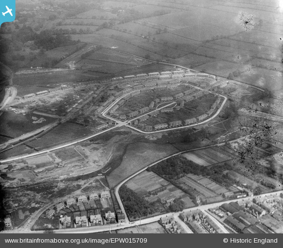
EPW015709 ENGLAND (1926). Housing estate around Alcuin Avenue, York, 1926
© Copyright OpenStreetMap contributors and licensed by the OpenStreetMap Foundation. 2026. Cartography is licensed as CC BY-SA.
Nearby Images (10)
EPW015709

EPW015710

EPW016079

EPW016078

EPW016077

EPW015712

EPW016115

EPW015711

EPW016111

EPW016076

Details
| Title | [EPW015709] Housing estate around Alcuin Avenue, York, 1926 |
| Reference | EPW015709 |
| Date | May-1926 |
| Link | |
| Place name | YORK |
| Parish | |
| District | |
| Country | ENGLAND |
| Easting / Northing | 462193, 451638 |
| Longitude / Latitude | -1.0520804275359, 53.956892665979 |
| National Grid Reference | SE622516 |
Pins

Ray Ban |
Thursday 29th of January 2015 10:50:16 PM | |
|
Ray Ban |
Thursday 29th of January 2015 10:40:02 PM | |

Class31 |
Sunday 20th of January 2013 08:26:18 PM | |
|
Class31 |
Sunday 20th of January 2013 08:25:28 PM | |
|
Class31 |
Sunday 20th of January 2013 08:24:46 PM | |
|
Class31 |
Sunday 20th of January 2013 08:23:34 PM | |
|
Class31 |
Sunday 20th of January 2013 08:21:03 PM | |
|
Class31 |
Sunday 20th of January 2013 08:20:25 PM | |
|
Class31 |
Sunday 20th of January 2013 08:17:44 PM | |
|
Class31 |
Sunday 20th of January 2013 08:17:06 PM | |
|
Class31 |
Sunday 20th of January 2013 08:16:12 PM | |

Dodweld |
Sunday 21st of October 2012 12:40:13 PM |
User Comment Contributions
This is Kingsway North, Clifton York, one of the new council estates built just before World War II |
martinyellow |
Tuesday 11th of December 2012 02:22:22 PM |