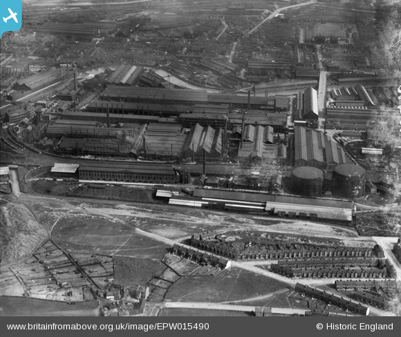
EPW015490 ENGLAND (1926). The Grimesthorpe Gas Works and River Don Armour Plate and Gun Works, Sheffield, 1926
© Copyright OpenStreetMap contributors and licensed by the OpenStreetMap Foundation. 2026. Cartography is licensed as CC BY-SA.
Nearby Images (18)
Details
| Title | [EPW015490] The Grimesthorpe Gas Works and River Don Armour Plate and Gun Works, Sheffield, 1926 |
| Reference | EPW015490 |
| Date | 4-May-1926 |
| Link | |
| Place name | SHEFFIELD |
| Parish | |
| District | |
| Country | ENGLAND |
| Easting / Northing | 438169, 390219 |
| Longitude / Latitude | -1.4257764406235, 53.407144828138 |
| National Grid Reference | SK382902 |
Pins

circloy |
Thursday 12th of September 2013 11:26:37 PM | |

Class31 |
Friday 26th of October 2012 03:34:15 PM | |

Class31 |
Friday 26th of October 2012 03:32:05 PM | |

Class31 |
Friday 26th of October 2012 03:31:51 PM | |

Class31 |
Friday 26th of October 2012 03:31:23 PM | |

Class31 |
Friday 26th of October 2012 03:30:48 PM | |

Class31 |
Friday 26th of October 2012 03:30:31 PM | |

Class31 |
Friday 26th of October 2012 03:30:02 PM | |

Class31 |
Friday 26th of October 2012 03:29:29 PM |


![[EPW015490] The Grimesthorpe Gas Works and River Don Armour Plate and Gun Works, Sheffield, 1926](http://britainfromabove.org.uk/sites/all/libraries/aerofilms-images/public/100x100/EPW/015/EPW015490.jpg)
![[EAW026017] The English Steel Corporation Ltd River Don Works and environs, Brightside, 1949. This image was marked by Aerofilms Ltd for photo editing.](http://britainfromabove.org.uk/sites/all/libraries/aerofilms-images/public/100x100/EAW/026/EAW026017.jpg)
![[EPW007796] The Vickers Works, Sheffield, 1922](http://britainfromabove.org.uk/sites/all/libraries/aerofilms-images/public/100x100/EPW/007/EPW007796.jpg)
![[EAW026018] The English Steel Corporation Ltd River Don Works and environs, Brightside, 1949. This image was marked by Aerofilms Ltd for photo editing.](http://britainfromabove.org.uk/sites/all/libraries/aerofilms-images/public/100x100/EAW/026/EAW026018.jpg)
![[EPW015601] The Grimesthorpe Gas Works, Sheffield, 1926](http://britainfromabove.org.uk/sites/all/libraries/aerofilms-images/public/100x100/EPW/015/EPW015601.jpg)
![[EPW015600] The Grimesthorpe Gas Works, Sheffield, 1926](http://britainfromabove.org.uk/sites/all/libraries/aerofilms-images/public/100x100/EPW/015/EPW015600.jpg)
![[EPW015599] The Grimesthorpe Gas Works, Sheffield, 1926](http://britainfromabove.org.uk/sites/all/libraries/aerofilms-images/public/100x100/EPW/015/EPW015599.jpg)
![[EPW007789] The Vickers Works and environs, Sheffield, 1922](http://britainfromabove.org.uk/sites/all/libraries/aerofilms-images/public/100x100/EPW/007/EPW007789.jpg)
![[EPW015485] The Grimesthorpe Gas Works, Sheffield, 1926](http://britainfromabove.org.uk/sites/all/libraries/aerofilms-images/public/100x100/EPW/015/EPW015485.jpg)
![[EAW026016] The English Steel Corporation Ltd River Don Works and environs, Brightside, 1949. This image was marked by Aerofilms Ltd for photo editing.](http://britainfromabove.org.uk/sites/all/libraries/aerofilms-images/public/100x100/EAW/026/EAW026016.jpg)
![[EPW015487] The Grimesthorpe Gas Works and River Don Armour Plate and Gun Works, Sheffield, 1926](http://britainfromabove.org.uk/sites/all/libraries/aerofilms-images/public/100x100/EPW/015/EPW015487.jpg)
![[EAW022024] The English Steel Corporation River Don Works, Sheffield, 1949. This image was marked by Aerofilms Ltd for photo editing.](http://britainfromabove.org.uk/sites/all/libraries/aerofilms-images/public/100x100/EAW/022/EAW022024.jpg)
![[EAW020055] The English Steel Corporation River Don Steel Works and environs, Brightside, 1948. This image has been produced from a print.](http://britainfromabove.org.uk/sites/all/libraries/aerofilms-images/public/100x100/EAW/020/EAW020055.jpg)
![[EAW022029] The English Steel Corporation River Don Works, Sheffield, from the north, 1949. This image was marked by Aerofilms Ltd for photo editing.](http://britainfromabove.org.uk/sites/all/libraries/aerofilms-images/public/100x100/EAW/022/EAW022029.jpg)
![[EAW018780] Brightside Sidings, the English Steel Corporation Ltd River Don Steel Works and environs, Brightside, 1948. This image was marked by Aerofilms Ltd for photo editing.](http://britainfromabove.org.uk/sites/all/libraries/aerofilms-images/public/100x100/EAW/018/EAW018780.jpg)
![[EAW022025] The English Steel Corporation River Don Works, Sheffield, 1949. This image was marked by Aerofilms Ltd for photo editing.](http://britainfromabove.org.uk/sites/all/libraries/aerofilms-images/public/100x100/EAW/022/EAW022025.jpg)
![[EAW018786] The English Steel Corporation Ltd River Don Steel Works and environs, Brightside, 1948. This image was marked by Aerofilms Ltd for photo editing.](http://britainfromabove.org.uk/sites/all/libraries/aerofilms-images/public/100x100/EAW/018/EAW018786.jpg)
![[EAW018781] The English Steel Corporation Ltd River Don Steel Works and environs, Brightside, 1948. This image was marked by Aerofilms Ltd for photo editing.](http://britainfromabove.org.uk/sites/all/libraries/aerofilms-images/public/100x100/EAW/018/EAW018781.jpg)