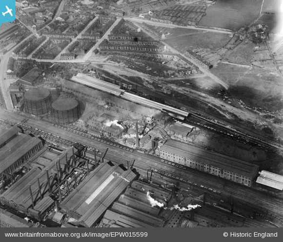
EPW015599 ENGLAND (1926). The Grimesthorpe Gas Works, Sheffield, 1926
© Copyright OpenStreetMap contributors and licensed by the OpenStreetMap Foundation. 2026. Cartography is licensed as CC BY-SA.
Nearby Images (10)
Details
| Title | [EPW015599] The Grimesthorpe Gas Works, Sheffield, 1926 |
| Reference | EPW015599 |
| Date | 4-May-1926 |
| Link | |
| Place name | SHEFFIELD |
| Parish | |
| District | |
| Country | ENGLAND |
| Easting / Northing | 438030, 390272 |
| Longitude / Latitude | -1.4278610827209, 53.407631289497 |
| National Grid Reference | SK380903 |
Pins

circloy |
Thursday 12th of September 2013 11:27:44 PM | |

cat631 |
Sunday 11th of November 2012 08:48:28 PM | |

Class31 |
Friday 26th of October 2012 04:18:11 PM | |

Class31 |
Friday 26th of October 2012 04:17:44 PM | |

Class31 |
Friday 26th of October 2012 04:17:19 PM | |

Class31 |
Friday 26th of October 2012 04:16:51 PM | |

Class31 |
Friday 26th of October 2012 04:16:33 PM | |

Class31 |
Friday 26th of October 2012 04:15:57 PM | |

Class31 |
Friday 26th of October 2012 04:15:41 PM | |

Class31 |
Friday 26th of October 2012 04:15:14 PM | |

Class31 |
Friday 26th of October 2012 04:14:50 PM |


![[EPW015599] The Grimesthorpe Gas Works, Sheffield, 1926](http://britainfromabove.org.uk/sites/all/libraries/aerofilms-images/public/100x100/EPW/015/EPW015599.jpg)
![[EPW015601] The Grimesthorpe Gas Works, Sheffield, 1926](http://britainfromabove.org.uk/sites/all/libraries/aerofilms-images/public/100x100/EPW/015/EPW015601.jpg)
![[EPW015485] The Grimesthorpe Gas Works, Sheffield, 1926](http://britainfromabove.org.uk/sites/all/libraries/aerofilms-images/public/100x100/EPW/015/EPW015485.jpg)
![[EPW015487] The Grimesthorpe Gas Works and River Don Armour Plate and Gun Works, Sheffield, 1926](http://britainfromabove.org.uk/sites/all/libraries/aerofilms-images/public/100x100/EPW/015/EPW015487.jpg)
![[EPW015600] The Grimesthorpe Gas Works, Sheffield, 1926](http://britainfromabove.org.uk/sites/all/libraries/aerofilms-images/public/100x100/EPW/015/EPW015600.jpg)
![[EAW026017] The English Steel Corporation Ltd River Don Works and environs, Brightside, 1949. This image was marked by Aerofilms Ltd for photo editing.](http://britainfromabove.org.uk/sites/all/libraries/aerofilms-images/public/100x100/EAW/026/EAW026017.jpg)
![[EPW007796] The Vickers Works, Sheffield, 1922](http://britainfromabove.org.uk/sites/all/libraries/aerofilms-images/public/100x100/EPW/007/EPW007796.jpg)
![[EPW015490] The Grimesthorpe Gas Works and River Don Armour Plate and Gun Works, Sheffield, 1926](http://britainfromabove.org.uk/sites/all/libraries/aerofilms-images/public/100x100/EPW/015/EPW015490.jpg)
![[EAW026018] The English Steel Corporation Ltd River Don Works and environs, Brightside, 1949. This image was marked by Aerofilms Ltd for photo editing.](http://britainfromabove.org.uk/sites/all/libraries/aerofilms-images/public/100x100/EAW/026/EAW026018.jpg)
![[EPW007789] The Vickers Works and environs, Sheffield, 1922](http://britainfromabove.org.uk/sites/all/libraries/aerofilms-images/public/100x100/EPW/007/EPW007789.jpg)