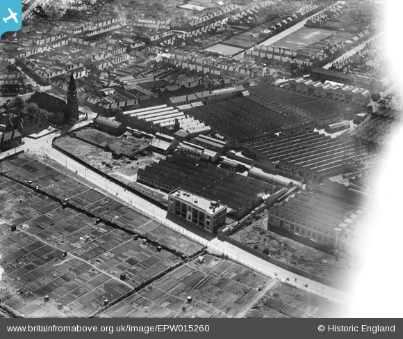
EPW015260 ENGLAND (1926). The Villiers Engineering Co Ltd Works, Wolverhampton, 1926
© Copyright OpenStreetMap contributors and licensed by the OpenStreetMap Foundation. 2025. Cartography is licensed as CC BY-SA.
Nearby Images (18)
Details
| Title | [EPW015260] The Villiers Engineering Co Ltd Works, Wolverhampton, 1926 |
| Reference | EPW015260 |
| Date | April-1926 |
| Link | |
| Place name | WOLVERHAMPTON |
| Parish | |
| District | |
| Country | ENGLAND |
| Easting / Northing | 391190, 297232 |
| Longitude / Latitude | -2.1300084095749, 52.572479255824 |
| National Grid Reference | SO912972 |
Pins

David |
Friday 9th of January 2015 07:15:02 PM |


![[EPW015260] The Villiers Engineering Co Ltd Works, Wolverhampton, 1926](http://britainfromabove.org.uk/sites/all/libraries/aerofilms-images/public/100x100/EPW/015/EPW015260.jpg)
![[EPW015262] The Villiers Engineering Co Ltd Works, Wolverhampton, 1926](http://britainfromabove.org.uk/sites/all/libraries/aerofilms-images/public/100x100/EPW/015/EPW015262.jpg)
![[EPW050140] The Villiers Engineering Works, Marston Road and environs, Blakenhall, 1936](http://britainfromabove.org.uk/sites/all/libraries/aerofilms-images/public/100x100/EPW/050/EPW050140.jpg)
![[EPW015263] The Villiers Engineering Co Ltd Works, Wolverhampton, 1926](http://britainfromabove.org.uk/sites/all/libraries/aerofilms-images/public/100x100/EPW/015/EPW015263.jpg)
![[EPW015261] The Villiers Engineering Co Ltd Works, Wolverhampton, 1926](http://britainfromabove.org.uk/sites/all/libraries/aerofilms-images/public/100x100/EPW/015/EPW015261.jpg)
![[EPW008127] The Sunbeam Motor Works, Blakenhall, 1922](http://britainfromabove.org.uk/sites/all/libraries/aerofilms-images/public/100x100/EPW/008/EPW008127.jpg)
![[EPW050147] The Villiers Engineering Works, Marston Road and environs, Blakenhall, 1936](http://britainfromabove.org.uk/sites/all/libraries/aerofilms-images/public/100x100/EPW/050/EPW050147.jpg)
![[EPW008123] The Sunbeam Motor Works, Blakenhall, 1922](http://britainfromabove.org.uk/sites/all/libraries/aerofilms-images/public/100x100/EPW/008/EPW008123.jpg)
![[EPW049917] The Villiers Engineering Co Ltd Works and environs, Blakenhall, 1936. This image has been produced from a print.](http://britainfromabove.org.uk/sites/all/libraries/aerofilms-images/public/100x100/EPW/049/EPW049917.jpg)
![[EPW008122] The Sunbeam Motor Works, Blakenhall, 1922](http://britainfromabove.org.uk/sites/all/libraries/aerofilms-images/public/100x100/EPW/008/EPW008122.jpg)
![[EPW008121] The Sunbeam Motor Works, Blakenhall, 1922](http://britainfromabove.org.uk/sites/all/libraries/aerofilms-images/public/100x100/EPW/008/EPW008121.jpg)
![[EPW050146] The Alustar Works, the Villiers Engineering Works and environs, Blakenhall, 1936](http://britainfromabove.org.uk/sites/all/libraries/aerofilms-images/public/100x100/EPW/050/EPW050146.jpg)
![[EPW050143] Clayton Close and Stanford Road, Blakenhall, 1936](http://britainfromabove.org.uk/sites/all/libraries/aerofilms-images/public/100x100/EPW/050/EPW050143.jpg)
![[EPW050142] The Villiers Engineering Works, Marston Road and environs, Blakenhall, 1936](http://britainfromabove.org.uk/sites/all/libraries/aerofilms-images/public/100x100/EPW/050/EPW050142.jpg)
![[EPW050148] The Villiers Engineering Works and environs, Blakenhall, 1936](http://britainfromabove.org.uk/sites/all/libraries/aerofilms-images/public/100x100/EPW/050/EPW050148.jpg)
![[EPW050141] The Villiers Engineering Works, Marston Road and environs, Blakenhall, 1936](http://britainfromabove.org.uk/sites/all/libraries/aerofilms-images/public/100x100/EPW/050/EPW050141.jpg)
![[EPW050145] The Villiers Engineering Works, Marston Road and environs, Blakenhall, 1936](http://britainfromabove.org.uk/sites/all/libraries/aerofilms-images/public/100x100/EPW/050/EPW050145.jpg)
![[EPW050144] The Alustar Works and the Villiers Engineering Works, Blakenhall, 1936](http://britainfromabove.org.uk/sites/all/libraries/aerofilms-images/public/100x100/EPW/050/EPW050144.jpg)