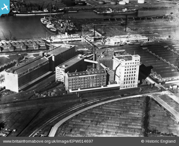
EPW014697 ENGLAND (1926). Co-operative Wholesale Society Flour Mill and other buildings at the Royal Edward Dock, Avonmouth, 1926. This image has been produced from a print.
© Copyright OpenStreetMap contributors and licensed by the OpenStreetMap Foundation. 2026. Cartography is licensed as CC BY-SA.
Nearby Images (19)
Details
| Title | [EPW014697] Co-operative Wholesale Society Flour Mill and other buildings at the Royal Edward Dock, Avonmouth, 1926. This image has been produced from a print. |
| Reference | EPW014697 |
| Date | 25-February-1926 |
| Link | |
| Place name | AVONMOUTH |
| Parish | |
| District | |
| Country | ENGLAND |
| Easting / Northing | 351344, 178591 |
| Longitude / Latitude | -2.701093994674, 51.503673418991 |
| National Grid Reference | ST513786 |
Pins
Be the first to add a comment to this image!


![[EPW014697] Co-operative Wholesale Society Flour Mill and other buildings at the Royal Edward Dock, Avonmouth, 1926. This image has been produced from a print.](http://britainfromabove.org.uk/sites/all/libraries/aerofilms-images/public/100x100/EPW/014/EPW014697.jpg)
![[EPW044776] Co-operative Wholesale Society Flour Mill and other buildings at the Royal Edward Dock, Avonmouth, 1934](http://britainfromabove.org.uk/sites/all/libraries/aerofilms-images/public/100x100/EPW/044/EPW044776.jpg)
![[EPW044775] Co-operative Wholesale Society Flour Mill and other buildings at the Royal Edward Dock, Avonmouth, 1934](http://britainfromabove.org.uk/sites/all/libraries/aerofilms-images/public/100x100/EPW/044/EPW044775.jpg)
![[EPW044780] Co-operative Wholesale Society Flour Mill and other buildings at the Royal Edward Dock, Avonmouth, 1934](http://britainfromabove.org.uk/sites/all/libraries/aerofilms-images/public/100x100/EPW/044/EPW044780.jpg)
![[EPW044778] Co-operative Wholesale Society Flour Mill and other buildings at the Royal Edward Dock, Avonmouth, 1934](http://britainfromabove.org.uk/sites/all/libraries/aerofilms-images/public/100x100/EPW/044/EPW044778.jpg)
![[EPW044779] The Royal Edward Dock, Avonmouth, from the south-east, 1934](http://britainfromabove.org.uk/sites/all/libraries/aerofilms-images/public/100x100/EPW/044/EPW044779.jpg)
![[EPW044781] The Royal Edward Dock, Avonmouth, from the south-east, 1934](http://britainfromabove.org.uk/sites/all/libraries/aerofilms-images/public/100x100/EPW/044/EPW044781.jpg)
![[EPW044777] Co-operative Wholesale Society Flour Mill and other buildings at the Royal Edward Dock, Avonmouth, 1934](http://britainfromabove.org.uk/sites/all/libraries/aerofilms-images/public/100x100/EPW/044/EPW044777.jpg)
![[EPW005537] The Royal Edward Dock, Avonmouth, 1921](http://britainfromabove.org.uk/sites/all/libraries/aerofilms-images/public/100x100/EPW/005/EPW005537.jpg)
![[EPW019269] The Royal Edward Dock, Avonmouth, 1927](http://britainfromabove.org.uk/sites/all/libraries/aerofilms-images/public/100x100/EPW/019/EPW019269.jpg)
![[EPW008648] Granary at Royal Edward Dock, Avonmouth, 1923](http://britainfromabove.org.uk/sites/all/libraries/aerofilms-images/public/100x100/EPW/008/EPW008648.jpg)
![[EPW019268] The docks and environs, Avonmouth, 1927](http://britainfromabove.org.uk/sites/all/libraries/aerofilms-images/public/100x100/EPW/019/EPW019268.jpg)
![[EPW005533] The Royal Edward Dock, Avonmouth, 1921. This image has been produced from a print.](http://britainfromabove.org.uk/sites/all/libraries/aerofilms-images/public/100x100/EPW/005/EPW005533.jpg)
![[EPW005518] No. 1 Granary and warehouses beside the Royal Edward Dock, Avonmouth, from the south-west, 1921](http://britainfromabove.org.uk/sites/all/libraries/aerofilms-images/public/100x100/EPW/005/EPW005518.jpg)
![[EAW002243] The Port of Bristol Authority Royal Edward Docks, Avonmouth, from the south, 1946. This image has been produced from a print.](http://britainfromabove.org.uk/sites/all/libraries/aerofilms-images/public/100x100/EAW/002/EAW002243.jpg)
![[EAW002256] The Port of Bristol Authority Royal Edward Docks, Avonmouth, 1946. This image has been produced from a print.](http://britainfromabove.org.uk/sites/all/libraries/aerofilms-images/public/100x100/EAW/002/EAW002256.jpg)
![[EPW005530] The Royal Edward Dock, Avonmouth, 1921](http://britainfromabove.org.uk/sites/all/libraries/aerofilms-images/public/100x100/EPW/005/EPW005530.jpg)
![[EPW005529] The Junction Cut and the village, Avonmouth, 1921](http://britainfromabove.org.uk/sites/all/libraries/aerofilms-images/public/100x100/EPW/005/EPW005529.jpg)
![[EPW037152] Avonmouth Docks, Avonmouth, from the south-west, 1931. This image has been produced from a copy-negative.](http://britainfromabove.org.uk/sites/all/libraries/aerofilms-images/public/100x100/EPW/037/EPW037152.jpg)