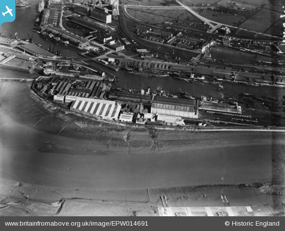
EPW014691 ENGLAND (1926). Avonmouth Dock, Avonmouth, 1926. This image has been produced from a print.
© Copyright OpenStreetMap contributors and licensed by the OpenStreetMap Foundation. 2026. Cartography is licensed as CC BY-SA.
Nearby Images (17)
Details
| Title | [EPW014691] Avonmouth Dock, Avonmouth, 1926. This image has been produced from a print. |
| Reference | EPW014691 |
| Date | 25-February-1926 |
| Link | |
| Place name | AVONMOUTH |
| Parish | |
| District | |
| Country | ENGLAND |
| Easting / Northing | 351088, 177896 |
| Longitude / Latitude | -2.7046860603182, 51.497401996389 |
| National Grid Reference | ST511779 |
Pins
Be the first to add a comment to this image!


![[EPW014691] Avonmouth Dock, Avonmouth, 1926. This image has been produced from a print.](http://britainfromabove.org.uk/sites/all/libraries/aerofilms-images/public/100x100/EPW/014/EPW014691.jpg)
![[EPW043043] The granaries on Nelson Point beside Avonmouth Dock, Avonmouth, 1933](http://britainfromabove.org.uk/sites/all/libraries/aerofilms-images/public/100x100/EPW/043/EPW043043.jpg)
![[EPW046970] Avonmouth Dock, the Royal Edward Dock and environs, Avonmouth, from the south, 1935](http://britainfromabove.org.uk/sites/all/libraries/aerofilms-images/public/100x100/EPW/046/EPW046970.jpg)
![[EPW005513] Avonmouth Dock, Avonmouth, from the south-west, 1921](http://britainfromabove.org.uk/sites/all/libraries/aerofilms-images/public/100x100/EPW/005/EPW005513.jpg)
![[EPW043044] The granaries on Nelson Point beside Avonmouth Dock, Avonmouth, 1933](http://britainfromabove.org.uk/sites/all/libraries/aerofilms-images/public/100x100/EPW/043/EPW043044.jpg)
![[EPW008649] The Avonmouth Oil Mills and Granaries, Avonmouth, 1923](http://britainfromabove.org.uk/sites/all/libraries/aerofilms-images/public/100x100/EPW/008/EPW008649.jpg)
![[EPW005488] Avonmouth Dock, Avonmouth, 1921](http://britainfromabove.org.uk/sites/all/libraries/aerofilms-images/public/100x100/EPW/005/EPW005488.jpg)
![[EPW005487] Avonmouth Dock, Avonmouth, 1921](http://britainfromabove.org.uk/sites/all/libraries/aerofilms-images/public/100x100/EPW/005/EPW005487.jpg)
![[EPW008651] The Avonmouth Dock, Avonmouth, 1923](http://britainfromabove.org.uk/sites/all/libraries/aerofilms-images/public/100x100/EPW/008/EPW008651.jpg)
![[EAW002071] Avonmouth Docks, Avonmouth, 1946. This image has been produced from a print.](http://britainfromabove.org.uk/sites/all/libraries/aerofilms-images/public/100x100/EAW/002/EAW002071.jpg)
![[EPW027951] Avonmouth Dock and environs, Avonmouth, 1929](http://britainfromabove.org.uk/sites/all/libraries/aerofilms-images/public/100x100/EPW/027/EPW027951.jpg)
![[EPW027954] Avonmouth Dock, Avonmouth, 1929. This image has been produced from a print.](http://britainfromabove.org.uk/sites/all/libraries/aerofilms-images/public/100x100/EPW/027/EPW027954.jpg)
![[EPR000058] Flour Mills alongside Avonmouth Dock, Avonmouth, 1934. This image has been affected by flare.](http://britainfromabove.org.uk/sites/all/libraries/aerofilms-images/public/100x100/EPR/000/EPR000058.jpg)
![[EPR000059] Flour Mills alongside Avonmouth Dock, Avonmouth, 1934](http://britainfromabove.org.uk/sites/all/libraries/aerofilms-images/public/100x100/EPR/000/EPR000059.jpg)
![[EPW043048] Avonmouth Dock, Avonmouth, from the north-west, 1933](http://britainfromabove.org.uk/sites/all/libraries/aerofilms-images/public/100x100/EPW/043/EPW043048.jpg)
![[EPW043049] The granaries on Nelson Point beside Avonmouth Dock, Avonmouth, from the north-west, 1933](http://britainfromabove.org.uk/sites/all/libraries/aerofilms-images/public/100x100/EPW/043/EPW043049.jpg)
![[EPW043046] The granaries on Nelson Point beside Avonmouth Dock, Avonmouth, from the north-west, 1933](http://britainfromabove.org.uk/sites/all/libraries/aerofilms-images/public/100x100/EPW/043/EPW043046.jpg)