
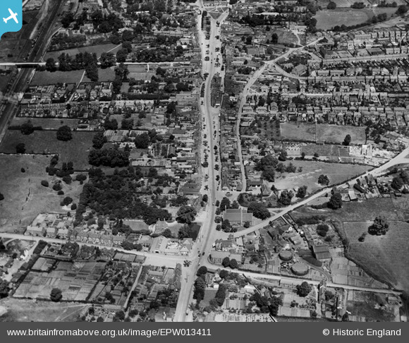
EPW013411 ENGLAND (1925). The High Street, Stevenage, 1925
© Copyright OpenStreetMap contributors and licensed by the OpenStreetMap Foundation. 2026. Cartography is licensed as CC BY-SA.
Nearby Images (9)
EPW013411

EPW025524

EAW034136

EAW034137

EAW023206

EAW034139

EPW013410

EPW025526

EAW023208

Details
| Title | [EPW013411] The High Street, Stevenage, 1925 |
| Reference | EPW013411 |
| Date | June-1925 |
| Link | |
| Place name | STEVENAGE |
| Parish | |
| District | |
| Country | ENGLAND |
| Easting / Northing | 523415, 224957 |
| Longitude / Latitude | -0.20566460300618, 51.909021865284 |
| National Grid Reference | TL234250 |
Pins

paulinuk |
Sunday 3rd of October 2021 03:43:57 PM | |
|
paulinuk |
Thursday 15th of July 2021 01:06:46 PM | |
|
paulinuk |
Thursday 15th of July 2021 01:03:03 PM | |
|
paulinuk |
Saturday 16th of November 2019 10:18:23 PM | |
|
andy |
Wednesday 24th of July 2019 09:30:11 AM | |
|
David960 |
Friday 23rd of January 2015 06:36:25 PM | |
|
David960 |
Friday 23rd of January 2015 06:35:30 PM | |
|
Hugh Madgin |
Wednesday 29th of January 2014 05:18:23 PM | |
|
Hugh Madgin |
Tuesday 5th of November 2013 06:16:59 AM | |
 |
Hugh Madgin |
Wednesday 22nd of May 2013 07:28:11 PM |
|
Hugh Madgin |
Wednesday 22nd of May 2013 06:23:30 PM | |
|
Hugh Madgin |
Wednesday 22nd of May 2013 06:21:09 PM | |
|
Howie |
Tuesday 22nd of January 2013 04:42:52 AM | |
|
Chells809 |
Monday 19th of November 2012 12:05:09 PM | |
|
Chells809 |
Sunday 14th of October 2012 09:52:50 PM | |
|
Chells809 |
Sunday 14th of October 2012 09:49:44 PM | |
|
Chells809 |
Monday 8th of October 2012 10:12:53 PM | |

Class31 |
Saturday 6th of October 2012 05:27:58 PM | |
|
Class31 |
Saturday 6th of October 2012 05:26:13 PM | |
|
Class31 |
Saturday 6th of October 2012 05:25:04 PM | |
|
Class31 |
Saturday 6th of October 2012 05:21:13 PM | |
For more information on this memorial, see www.roll-of-honour.com/Hertfordshire/Stevenage.html. |

melgibbs |
Thursday 19th of March 2015 08:32:59 PM |
|
Class31 |
Saturday 6th of October 2012 05:19:21 PM | |
|
Class31 |
Saturday 6th of October 2012 05:18:02 PM | |
|
Class31 |
Saturday 6th of October 2012 05:17:38 PM | |
|
Class31 |
Saturday 6th of October 2012 05:16:39 PM | |
|
Class31 |
Saturday 6th of October 2012 05:16:00 PM | |
|
Class31 |
Saturday 6th of October 2012 05:13:14 PM |
User Comment Contributions
A clear image of the former market town of Stevenage in north Hertfordshire, looking north along the line of the old A1 (Great North Road), when the settlement consisted of fewer than 5,000 people. Just over twenty years later, in the immediate postwar period, Stevenage was designated as one of the original New Towns and it grew rapidly throughout the following decades to more than 85,000. |

John Swain |
Thursday 6th of June 2013 09:24:57 PM |
Good choice of pic, but this is the old town of Stevenage. Construction on Stevenage new town commenced in the late 1940s, at first some way away from the original older town located along the Great North Road which is pictured here. In time the new town pretty much joined up with the old town though the old town still has a very distinctive country market town atmosphere. Any chance of a later pic of the new town under construction in the late 40s/early 50s? To illustrate changes in town planning in Britain this pic must be a candidate for the book, though it would be enhanced if a more recent pic could be added. |
Chells809 |
Thursday 6th of June 2013 09:24:57 PM |