
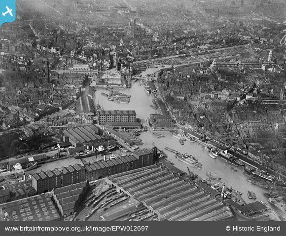
EPW012697 ENGLAND (1925). Prince's Dock and the city centre, Kingston upon Hull, 1925
© Copyright OpenStreetMap contributors and licensed by the OpenStreetMap Foundation. 2026. Cartography is licensed as CC BY-SA.
Nearby Images (11)
EPW012697

EPW012818

EAW046136

EAW028627

EAW028626

EPW036497

EPW036495

EAW046134

EPW036496

EPW010789

EPW012696

Details
| Title | [EPW012697] Prince's Dock and the city centre, Kingston upon Hull, 1925 |
| Reference | EPW012697 |
| Date | 6-May-1925 |
| Link | |
| Place name | KINGSTON UPON HULL |
| Parish | |
| District | |
| Country | ENGLAND |
| Easting / Northing | 509664, 428511 |
| Longitude / Latitude | -0.3370710016214, 53.74120854393 |
| National Grid Reference | TA097285 |
Pins

John Wass |
Thursday 11th of June 2020 03:31:59 PM | |
|
John Wass |
Thursday 11th of June 2020 03:27:29 PM | |
|
Chris Kolonko |
Wednesday 24th of July 2019 03:41:53 PM | |
|
John Wass |
Tuesday 16th of May 2017 11:50:44 AM | |
|
Edmund |
Monday 15th of May 2017 06:19:01 PM | |
|
Val |
Saturday 26th of November 2016 01:44:57 PM | |
|
Val |
Saturday 26th of November 2016 01:44:35 PM | |
|
Val |
Saturday 26th of November 2016 01:44:20 PM | |
|
Val |
Saturday 26th of November 2016 01:44:02 PM | |
|
Val |
Saturday 26th of November 2016 01:43:44 PM | |
|
Nick |
Thursday 24th of July 2014 05:33:43 PM | |
|
John Wass |
Wednesday 2nd of July 2014 03:00:02 PM | |
|
rachelst |
Friday 6th of June 2014 03:23:12 PM | |
Sorry, no it isn't. I believe it was a bank destroyed by bombing in 1941. The museum is in the old Docks offices on the other side of New Cross Street. |
John Wass |
Friday 24th of April 2015 03:55:16 PM |
It's the old Prudential Building that was bombed. The Town Docks Museum is the triangular, three-domed buiiding just to the right. |
Val |
Saturday 26th of November 2016 01:58:18 PM |