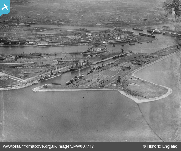
EPW007747 ENGLAND (1922). Ramsden Dock Basin and lock, Barrow-in-Furness, 1922
© Copyright OpenStreetMap contributors and licensed by the OpenStreetMap Foundation. 2026. Cartography is licensed as CC BY-SA.
Nearby Images (6)
Details
| Title | [EPW007747] Ramsden Dock Basin and lock, Barrow-in-Furness, 1922 |
| Reference | EPW007747 |
| Date | April-1922 |
| Link | |
| Place name | BARROW-IN-FURNESS |
| Parish | |
| District | |
| Country | ENGLAND |
| Easting / Northing | 320171, 467290 |
| Longitude / Latitude | -3.2207734545722, 54.095130432706 |
| National Grid Reference | SD202673 |
Pins
Be the first to add a comment to this image!


![[EPW007747] Ramsden Dock Basin and lock, Barrow-in-Furness, 1922](http://britainfromabove.org.uk/sites/all/libraries/aerofilms-images/public/100x100/EPW/007/EPW007747.jpg)
![[EPW004066] Dock Basin, Anchor Basin and Ramsden Dock, Barrow-in-Furness, 1920](http://britainfromabove.org.uk/sites/all/libraries/aerofilms-images/public/100x100/EPW/004/EPW004066.jpg)
![[EPW007746] Ramsden Dock Basin and lock, Barrow-in-Furness, 1922](http://britainfromabove.org.uk/sites/all/libraries/aerofilms-images/public/100x100/EPW/007/EPW007746.jpg)
![[EPW007742] Ramsden Dock Basin and lock, Barrow-in-Furness, 1922](http://britainfromabove.org.uk/sites/all/libraries/aerofilms-images/public/100x100/EPW/007/EPW007742.jpg)
![[EPW007744] Ramsden Dock lock and Anchor Basin, Barrow-in-Furness, 1922](http://britainfromabove.org.uk/sites/all/libraries/aerofilms-images/public/100x100/EPW/007/EPW007744.jpg)
![[EPW007745] The docks, Barrow-in-Furness, from the south-west, 1922](http://britainfromabove.org.uk/sites/all/libraries/aerofilms-images/public/100x100/EPW/007/EPW007745.jpg)