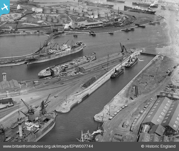
EPW007744 ENGLAND (1922). Ramsden Dock lock and Anchor Basin, Barrow-in-Furness, 1922
© Copyright OpenStreetMap contributors and licensed by the OpenStreetMap Foundation. 2026. Cartography is licensed as CC BY-SA.
Details
| Title | [EPW007744] Ramsden Dock lock and Anchor Basin, Barrow-in-Furness, 1922 |
| Reference | EPW007744 |
| Date | April-1922 |
| Link | |
| Place name | BARROW-IN-FURNESS |
| Parish | |
| District | |
| Country | ENGLAND |
| Easting / Northing | 320280, 467510 |
| Longitude / Latitude | -3.2191649851451, 54.097124365055 |
| National Grid Reference | SD203675 |
Pins

Ebdon |
Tuesday 20th of April 2021 11:25:56 PM | |

MB |
Monday 24th of September 2012 11:21:40 AM | |

MB |
Monday 24th of September 2012 11:20:09 AM | |

MB |
Monday 24th of September 2012 11:19:27 AM | |

MB |
Monday 24th of September 2012 11:19:02 AM | |

MB |
Monday 24th of September 2012 11:17:52 AM | |

MB |
Monday 24th of September 2012 11:15:53 AM | |

MB |
Monday 24th of September 2012 11:15:27 AM |


![[EPW007744] Ramsden Dock lock and Anchor Basin, Barrow-in-Furness, 1922](http://britainfromabove.org.uk/sites/all/libraries/aerofilms-images/public/100x100/EPW/007/EPW007744.jpg)
![[EPW007743] Ramsden Dock Basin and lock, Barrow-in-Furness, 1922](http://britainfromabove.org.uk/sites/all/libraries/aerofilms-images/public/100x100/EPW/007/EPW007743.jpg)
![[EPW007747] Ramsden Dock Basin and lock, Barrow-in-Furness, 1922](http://britainfromabove.org.uk/sites/all/libraries/aerofilms-images/public/100x100/EPW/007/EPW007747.jpg)
![[EPW004066] Dock Basin, Anchor Basin and Ramsden Dock, Barrow-in-Furness, 1920](http://britainfromabove.org.uk/sites/all/libraries/aerofilms-images/public/100x100/EPW/004/EPW004066.jpg)