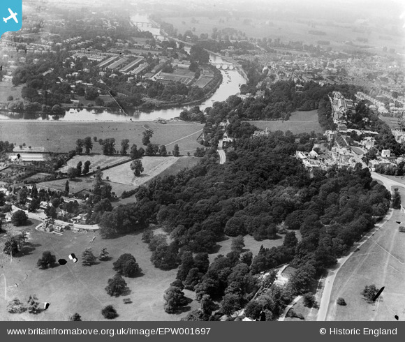
EPW001697 ENGLAND (1920). Petersham Common and Richmond Bridge, Richmond, 1920
© Copyright OpenStreetMap contributors and licensed by the OpenStreetMap Foundation. 2026. Cartography is licensed as CC BY-SA.
Nearby Images (20)
Details
| Title | [EPW001697] Petersham Common and Richmond Bridge, Richmond, 1920 |
| Reference | EPW001697 |
| Date | June-1920 |
| Link | |
| Place name | RICHMOND |
| Parish | |
| District | |
| Country | ENGLAND |
| Easting / Northing | 518225, 173695 |
| Longitude / Latitude | -0.29844705548752, 51.449393550604 |
| National Grid Reference | TQ182737 |
Pins

Martin Devlin |
Tuesday 19th of April 2022 11:48:41 AM | |

Martin Devlin |
Tuesday 19th of April 2022 11:48:19 AM | |

Martin Devlin |
Tuesday 19th of April 2022 11:45:30 AM | |

Martin Devlin |
Tuesday 19th of April 2022 11:44:58 AM |


![[EPW001697] Petersham Common and Richmond Bridge, Richmond, 1920](http://britainfromabove.org.uk/sites/all/libraries/aerofilms-images/public/100x100/EPW/001/EPW001697.jpg)
![[EAW006952] The house of Sir John Archer alongside Terrace Field, Richmond Hill, 1947](http://britainfromabove.org.uk/sites/all/libraries/aerofilms-images/public/100x100/EAW/006/EAW006952.jpg)
![[EAW008243] The River Thames and Glover's Island at Petersham, Richmond, 1947](http://britainfromabove.org.uk/sites/all/libraries/aerofilms-images/public/100x100/EAW/008/EAW008243.jpg)
![[EAW006954] The house of Sir John Archer alongside Terrace Field, Richmond Hill, 1947](http://britainfromabove.org.uk/sites/all/libraries/aerofilms-images/public/100x100/EAW/006/EAW006954.jpg)
![[EAW006951] The house of Sir John Archer alongside Terrace Field, Richmond Hill, 1947](http://britainfromabove.org.uk/sites/all/libraries/aerofilms-images/public/100x100/EAW/006/EAW006951.jpg)
![[EAW006955] The house of Sir John Archer and Petersham Well No. 1, Richmond Hill, 1947. This image was marked by Aerofilms Ltd for photo editing.](http://britainfromabove.org.uk/sites/all/libraries/aerofilms-images/public/100x100/EAW/006/EAW006955.jpg)
![[EPR000652] The Royal Star and Garter Home, Richmond Hill, 1935](http://britainfromabove.org.uk/sites/all/libraries/aerofilms-images/public/100x100/EPR/000/EPR000652.jpg)
![[EAW006963] The Star and Garter Home, Richmond Hill, 1947](http://britainfromabove.org.uk/sites/all/libraries/aerofilms-images/public/100x100/EAW/006/EAW006963.jpg)
![[EAW006964] The Star and Garter Home, Richmond Hill, 1947](http://britainfromabove.org.uk/sites/all/libraries/aerofilms-images/public/100x100/EAW/006/EAW006964.jpg)
![[EAW006956] The house of Sir John Archer and the surrounding area, Richmond Hill, 1947. This image was marked by Aerofilms Ltd for photo editing.](http://britainfromabove.org.uk/sites/all/libraries/aerofilms-images/public/100x100/EAW/006/EAW006956.jpg)
![[EAW006957] The house of Sir John Archer, Richmond Hill, 1947](http://britainfromabove.org.uk/sites/all/libraries/aerofilms-images/public/100x100/EAW/006/EAW006957.jpg)
![[EAW006958] The house of Sir John Archer, Richmond Hill, 1947](http://britainfromabove.org.uk/sites/all/libraries/aerofilms-images/public/100x100/EAW/006/EAW006958.jpg)
![[EAW006959] The house of Sir John Archer alongside Terrace Field, Richmond Hill, 1947](http://britainfromabove.org.uk/sites/all/libraries/aerofilms-images/public/100x100/EAW/006/EAW006959.jpg)
![[EAW006961] The house of Sir John Archer alongside Terrace Field, Richmond Hill, 1947](http://britainfromabove.org.uk/sites/all/libraries/aerofilms-images/public/100x100/EAW/006/EAW006961.jpg)
![[EAW006960] The house of Sir John Archer alongside Terrace Field, Richmond Hill, 1947](http://britainfromabove.org.uk/sites/all/libraries/aerofilms-images/public/100x100/EAW/006/EAW006960.jpg)
![[EAW006953] The house of Sir John Archer alongside Terrace Field, Richmond Hill, 1947](http://britainfromabove.org.uk/sites/all/libraries/aerofilms-images/public/100x100/EAW/006/EAW006953.jpg)
![[EPW022833] The Star and Garter Home, Richmond, 1928](http://britainfromabove.org.uk/sites/all/libraries/aerofilms-images/public/100x100/EPW/022/EPW022833.jpg)
![[EPW022834] The Star and Garter Home, Richmond, 1928](http://britainfromabove.org.uk/sites/all/libraries/aerofilms-images/public/100x100/EPW/022/EPW022834.jpg)
![[EPW010984] The Star and Garter Home and Ancaster House, Richmond, 1924. This image has been produced from a print.](http://britainfromabove.org.uk/sites/all/libraries/aerofilms-images/public/100x100/EPW/010/EPW010984.jpg)
![[EAW006962] The Star and Garter Home, Richmond Hill, 1947](http://britainfromabove.org.uk/sites/all/libraries/aerofilms-images/public/100x100/EAW/006/EAW006962.jpg)