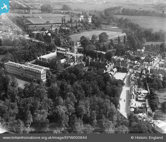
EPW000844 ENGLAND (1920). Magdalen College and Grove, Oxford, 1920
© Copyright OpenStreetMap contributors and licensed by the OpenStreetMap Foundation. 2026. Cartography is licensed as CC BY-SA.
Nearby Images (18)
Details
| Title | [EPW000844] Magdalen College and Grove, Oxford, 1920 |
| Reference | EPW000844 |
| Date | May-1920 |
| Link | |
| Place name | OXFORD |
| Parish | |
| District | |
| Country | ENGLAND |
| Easting / Northing | 452066, 206219 |
| Longitude / Latitude | -1.2456661342919, 51.751787609261 |
| National Grid Reference | SP521062 |


![[EPW000844] Magdalen College and Grove, Oxford, 1920](http://britainfromabove.org.uk/sites/all/libraries/aerofilms-images/public/100x100/EPW/000/EPW000844.jpg)
![[EAW045720] The Botanic Garden and Magdalen College, Oxford, 1952](http://britainfromabove.org.uk/sites/all/libraries/aerofilms-images/public/100x100/EAW/045/EAW045720.jpg)
![[EPW000828] Magdalen College area, Oxford, 1920](http://britainfromabove.org.uk/sites/all/libraries/aerofilms-images/public/100x100/EPW/000/EPW000828.jpg)
![[EAW003129] The High Street and the city, Oxford, from the south-east, 1946](http://britainfromabove.org.uk/sites/all/libraries/aerofilms-images/public/100x100/EAW/003/EAW003129.jpg)
![[EAW049093] Magdalen College, Oxford, 1953](http://britainfromabove.org.uk/sites/all/libraries/aerofilms-images/public/100x100/EAW/049/EAW049093.jpg)
![[EPW000822] Magdalen College, Magdalen Bridge and Botanic Gardens, Oxford, 1920](http://britainfromabove.org.uk/sites/all/libraries/aerofilms-images/public/100x100/EPW/000/EPW000822.jpg)
![[EAW045707] Magdelene College, Oxford, 1952. This image has been produced from a print.](http://britainfromabove.org.uk/sites/all/libraries/aerofilms-images/public/100x100/EAW/045/EAW045707.jpg)
![[EAW031683] Magdalen College and the Botanic Gardens, Oxford, 1950](http://britainfromabove.org.uk/sites/all/libraries/aerofilms-images/public/100x100/EAW/031/EAW031683.jpg)
![[EPW052772] Merton Field and surrounding Colleges, Oxford, 1937](http://britainfromabove.org.uk/sites/all/libraries/aerofilms-images/public/100x100/EPW/052/EPW052772.jpg)
![[EAW049089] Magdalen College and the Botanic Gardens, Oxford, 1953](http://britainfromabove.org.uk/sites/all/libraries/aerofilms-images/public/100x100/EAW/049/EAW049089.jpg)
![[EAW049088] Magdalen College and environs, Oxford, 1953](http://britainfromabove.org.uk/sites/all/libraries/aerofilms-images/public/100x100/EAW/049/EAW049088.jpg)
![[EAW047928] The city in the snow, Oxford, from the south-east, 1952](http://britainfromabove.org.uk/sites/all/libraries/aerofilms-images/public/100x100/EAW/047/EAW047928.jpg)
![[EPW000825] High Street, Oxford, 1920](http://britainfromabove.org.uk/sites/all/libraries/aerofilms-images/public/100x100/EPW/000/EPW000825.jpg)
![[EPW052770] The University Colleges and the city, Oxford, from the south-east, 1937](http://britainfromabove.org.uk/sites/all/libraries/aerofilms-images/public/100x100/EPW/052/EPW052770.jpg)
![[EPW052776] Magdalen Bridge and the city, Oxford, from the south-east, 1937](http://britainfromabove.org.uk/sites/all/libraries/aerofilms-images/public/100x100/EPW/052/EPW052776.jpg)
![[EAW014892] The city, Oxford, from the south-east, 1948. This image has been produced from a print.](http://britainfromabove.org.uk/sites/all/libraries/aerofilms-images/public/100x100/EAW/014/EAW014892.jpg)
![[EAW003604] The city centre, Oxford, from the east, 1947](http://britainfromabove.org.uk/sites/all/libraries/aerofilms-images/public/100x100/EAW/003/EAW003604.jpg)
![[EAW018726] The city, Oxford, from the east, 1948. This image has been produced from a print.](http://britainfromabove.org.uk/sites/all/libraries/aerofilms-images/public/100x100/EAW/018/EAW018726.jpg)


