
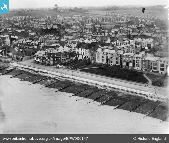
EPW000147 ENGLAND (1920). Central Parade, Herne Bay, 1920
© Copyright OpenStreetMap contributors and licensed by the OpenStreetMap Foundation. 2026. Cartography is licensed as CC BY-SA.
Nearby Images (5)
EPW000147

EPW035497

EPW035496

EPW035491

EPW054045

Details
| Title | [EPW000147] Central Parade, Herne Bay, 1920 |
| Reference | EPW000147 |
| Date | February-1920 |
| Link | |
| Place name | HERNE BAY |
| Parish | |
| District | |
| Country | ENGLAND |
| Easting / Northing | 618072, 168405 |
| Longitude / Latitude | 1.1335650521113, 51.372258063449 |
| National Grid Reference | TR181684 |
Pins
Be the first to add a comment to this image!
User Comment Contributions
Definitely Central Parade, Herne Bay, towards the eastern end. |

Dick |
Thursday 12th of July 2012 09:29:38 AM |
Dear all, That’s great; we’ve reviewed your comments and thanks to your help we can update the catalogue. The revised record will appear here in due course. Hope you have the same success solving some of our other mysteries! Katy Whitaker Britain from Above Cataloguer |
Katy Whitaker |
Monday 2nd of July 2012 12:17:31 PM |
I AGREE - I ASSUME THATS THE ORIG WATER TOWER IN THE BACKGROUND THATS NOW A CONCRETE ONE...? |
EWOK |
Tuesday 26th of June 2012 12:43:36 PM |
This is Herne Bay, Central Parade. Prospect Hill is the narrow street in the middle of the picture, by the big dark coloured house with East Street left centre. The diagonal path and gateway right centre show up clearly on Google street view. The area has hardly changed in terms of the structures. |
Thomas Allen |
Tuesday 26th of June 2012 08:26:28 AM |
Herne bay. Central Parade at the junction with Prospect Hill. |
Smitty |
Monday 25th of June 2012 10:37:59 PM |
This shows houses along Central Parade in Herne Bay, England. The building @ middle left has always been a Public Inn and is called The Ship. It is one of the oldest buildings in Herne Bay and is steeped in history. |
Shortcut Ben |
Monday 25th of June 2012 05:33:06 PM |