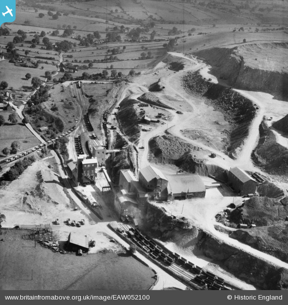
EAW052100 ENGLAND (1953). The Caldonlow Quarries, Cauldon, 1953
© Copyright OpenStreetMap contributors and licensed by the OpenStreetMap Foundation. 2026. Cartography is licensed as CC BY-SA.
Nearby Images (12)
Details
| Title | [EAW052100] The Caldonlow Quarries, Cauldon, 1953 |
| Reference | EAW052100 |
| Date | 7-September-1953 |
| Link | |
| Place name | CAULDON |
| Parish | WATERHOUSES |
| District | |
| Country | ENGLAND |
| Easting / Northing | 407494, 349055 |
| Longitude / Latitude | -1.888223200589, 53.038413449109 |
| National Grid Reference | SK075491 |
Pins
Be the first to add a comment to this image!


![[EAW052100] The Caldonlow Quarries, Cauldon, 1953](http://britainfromabove.org.uk/sites/all/libraries/aerofilms-images/public/100x100/EAW/052/EAW052100.jpg)
![[EAW052094] The Caldonlow Quarries, Cauldon, 1953](http://britainfromabove.org.uk/sites/all/libraries/aerofilms-images/public/100x100/EAW/052/EAW052094.jpg)
![[EAW052101] The Caldonlow Quarries, Cauldon, from the north, 1953](http://britainfromabove.org.uk/sites/all/libraries/aerofilms-images/public/100x100/EAW/052/EAW052101.jpg)
![[EAW052090] The Caldonlow Quarries, Cauldon, 1953](http://britainfromabove.org.uk/sites/all/libraries/aerofilms-images/public/100x100/EAW/052/EAW052090.jpg)
![[EAW052092] The Caldonlow Quarries, Cauldon, 1953](http://britainfromabove.org.uk/sites/all/libraries/aerofilms-images/public/100x100/EAW/052/EAW052092.jpg)
![[EAW052091] The Caldonlow Quarries, Cauldon, 1953](http://britainfromabove.org.uk/sites/all/libraries/aerofilms-images/public/100x100/EAW/052/EAW052091.jpg)
![[EAW052097] The Caldonlow Quarries, Cauldon, 1953](http://britainfromabove.org.uk/sites/all/libraries/aerofilms-images/public/100x100/EAW/052/EAW052097.jpg)
![[EAW052095] The Caldonlow Quarries and the village, Cauldon, from the south-west, 1953](http://britainfromabove.org.uk/sites/all/libraries/aerofilms-images/public/100x100/EAW/052/EAW052095.jpg)
![[EAW052086] The Caldonlow Quarries, Cauldon, 1953](http://britainfromabove.org.uk/sites/all/libraries/aerofilms-images/public/100x100/EAW/052/EAW052086.jpg)
![[EAW052096] The Caldonlow Quarries, Cauldon, from the north, 1953](http://britainfromabove.org.uk/sites/all/libraries/aerofilms-images/public/100x100/EAW/052/EAW052096.jpg)
![[EAW052087] The Caldonlow Quarries, Cauldon, 1953](http://britainfromabove.org.uk/sites/all/libraries/aerofilms-images/public/100x100/EAW/052/EAW052087.jpg)
![[EAW052089] The Caldonlow Quarries, Cauldon, 1953](http://britainfromabove.org.uk/sites/all/libraries/aerofilms-images/public/100x100/EAW/052/EAW052089.jpg)