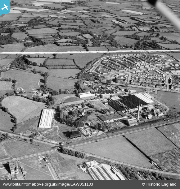
EAW051133 ENGLAND (1953). The British Cellophane Ltd Factory and surrounding area, Bridgwater, 1953. This image was marked by Aerofilms Ltd for photo editing.
© Copyright OpenStreetMap contributors and licensed by the OpenStreetMap Foundation. 2026. Cartography is licensed as CC BY-SA.
Nearby Images (19)
Details
| Title | [EAW051133] The British Cellophane Ltd Factory and surrounding area, Bridgwater, 1953. This image was marked by Aerofilms Ltd for photo editing. |
| Reference | EAW051133 |
| Date | 6-August-1953 |
| Link | |
| Place name | BRIDGWATER |
| Parish | BRIDGWATER |
| District | |
| Country | ENGLAND |
| Easting / Northing | 331282, 138269 |
| Longitude / Latitude | -2.982355958876, 51.13903641063 |
| National Grid Reference | ST313383 |
Pins
Be the first to add a comment to this image!


![[EAW051133] The British Cellophane Ltd Factory and surrounding area, Bridgwater, 1953. This image was marked by Aerofilms Ltd for photo editing.](http://britainfromabove.org.uk/sites/all/libraries/aerofilms-images/public/100x100/EAW/051/EAW051133.jpg)
![[EAW005152] The British Cellophane Ltd Factory and the surrounding countryside, Bridgwater, 1947](http://britainfromabove.org.uk/sites/all/libraries/aerofilms-images/public/100x100/EAW/005/EAW005152.jpg)
![[EAW005147] The British Cellophane Ltd Factory and the surrounding area, Bridgwater, 1947](http://britainfromabove.org.uk/sites/all/libraries/aerofilms-images/public/100x100/EAW/005/EAW005147.jpg)
![[EAW005146] The British Cellophane Ltd Factory and the surrounding area, Bridgwater, 1947](http://britainfromabove.org.uk/sites/all/libraries/aerofilms-images/public/100x100/EAW/005/EAW005146.jpg)
![[EAW051131] The British Cellophane Ltd Factory and surrounding area, Bridgwater, 1953. This image was marked by Aerofilms Ltd for photo editing.](http://britainfromabove.org.uk/sites/all/libraries/aerofilms-images/public/100x100/EAW/051/EAW051131.jpg)
![[EAW005143] The British Cellophane Ltd Factory and the surrounding area, Bridgwater, 1947](http://britainfromabove.org.uk/sites/all/libraries/aerofilms-images/public/100x100/EAW/005/EAW005143.jpg)
![[EAW005154] The British Cellophane Ltd Factory, Bridgwater, 1947](http://britainfromabove.org.uk/sites/all/libraries/aerofilms-images/public/100x100/EAW/005/EAW005154.jpg)
![[EAW005151] The British Cellophane Ltd Factory and the surrounding area, Bridgwater, from the east, 1947](http://britainfromabove.org.uk/sites/all/libraries/aerofilms-images/public/100x100/EAW/005/EAW005151.jpg)
![[EAW005156] Sydenham Manor, Bridgwater, 1947](http://britainfromabove.org.uk/sites/all/libraries/aerofilms-images/public/100x100/EAW/005/EAW005156.jpg)
![[EAW005142] The British Cellophane Ltd Factory and the surrounding area, Bridgwater, 1947](http://britainfromabove.org.uk/sites/all/libraries/aerofilms-images/public/100x100/EAW/005/EAW005142.jpg)
![[EAW051129] The British Cellophane Ltd Factory and surrounding area, Bridgwater, 1953. This image was marked by Aerofilms Ltd for photo editing.](http://britainfromabove.org.uk/sites/all/libraries/aerofilms-images/public/100x100/EAW/051/EAW051129.jpg)
![[EAW005155] The British Cellophane Ltd Factory, Bridgwater, 1947](http://britainfromabove.org.uk/sites/all/libraries/aerofilms-images/public/100x100/EAW/005/EAW005155.jpg)
![[EAW005149] The British Cellophane Ltd Factory, Bridgwater, 1947](http://britainfromabove.org.uk/sites/all/libraries/aerofilms-images/public/100x100/EAW/005/EAW005149.jpg)
![[EAW051130] The British Cellophane Ltd Factory and surrounding area, Bridgwater, 1953. This image was marked by Aerofilms Ltd for photo editing.](http://britainfromabove.org.uk/sites/all/libraries/aerofilms-images/public/100x100/EAW/051/EAW051130.jpg)
![[EAW005158] Sydenham Manor, Bridgwater, 1947](http://britainfromabove.org.uk/sites/all/libraries/aerofilms-images/public/100x100/EAW/005/EAW005158.jpg)
![[EAW005145] The British Cellophane Ltd Factory and the surrounding area, Bridgwater, 1947](http://britainfromabove.org.uk/sites/all/libraries/aerofilms-images/public/100x100/EAW/005/EAW005145.jpg)
![[EAW051128] The British Cellophane Ltd Factory and surrounding area, Bridgwater, 1953. This image was marked by Aerofilms Ltd for photo editing.](http://britainfromabove.org.uk/sites/all/libraries/aerofilms-images/public/100x100/EAW/051/EAW051128.jpg)
![[EAW005157] Sydenham Manor and the surrounding countryside, Bridgwater, from the west, 1947](http://britainfromabove.org.uk/sites/all/libraries/aerofilms-images/public/100x100/EAW/005/EAW005157.jpg)
![[EAW051132] The British Cellophane Ltd Factory and surrounding area, Bridgwater, 1953. This image was marked by Aerofilms Ltd for photo editing.](http://britainfromabove.org.uk/sites/all/libraries/aerofilms-images/public/100x100/EAW/051/EAW051132.jpg)