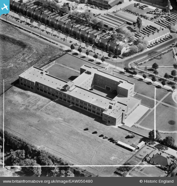
EAW050480 ENGLAND (1953). Office building on London Road, Purfleet, 1953. This image was marked by Aerofilms Ltd for photo editing.
© Copyright OpenStreetMap contributors and licensed by the OpenStreetMap Foundation. 2026. Cartography is licensed as CC BY-SA.
Nearby Images (23)
Details
| Title | [EAW050480] Office building on London Road, Purfleet, 1953. This image was marked by Aerofilms Ltd for photo editing. |
| Reference | EAW050480 |
| Date | 8-July-1953 |
| Link | |
| Place name | PURFLEET |
| Parish | |
| District | |
| Country | ENGLAND |
| Easting / Northing | 555944, 178041 |
| Longitude / Latitude | 0.24594692265809, 51.47931391857 |
| National Grid Reference | TQ559780 |
Pins
Be the first to add a comment to this image!


![[EAW050480] Office building on London Road, Purfleet, 1953. This image was marked by Aerofilms Ltd for photo editing.](http://britainfromabove.org.uk/sites/all/libraries/aerofilms-images/public/100x100/EAW/050/EAW050480.jpg)
![[EAW050476] Office building on London Road, Purfleet, 1953. This image was marked by Aerofilms Ltd for photo editing.](http://britainfromabove.org.uk/sites/all/libraries/aerofilms-images/public/100x100/EAW/050/EAW050476.jpg)
![[EAW050473] Office building on London Road, Purfleet, 1953. This image was marked by Aerofilms Ltd for photo editing.](http://britainfromabove.org.uk/sites/all/libraries/aerofilms-images/public/100x100/EAW/050/EAW050473.jpg)
![[EAW050477] Office building on London Road, Purfleet, 1953. This image was marked by Aerofilms Ltd for photo editing.](http://britainfromabove.org.uk/sites/all/libraries/aerofilms-images/public/100x100/EAW/050/EAW050477.jpg)
![[EAW050479] Office building on London Road, Purfleet, 1953](http://britainfromabove.org.uk/sites/all/libraries/aerofilms-images/public/100x100/EAW/050/EAW050479.jpg)
![[EAW050481] Office building on London Road, Purfleet, 1953](http://britainfromabove.org.uk/sites/all/libraries/aerofilms-images/public/100x100/EAW/050/EAW050481.jpg)
![[EAW050474] Office building on London Road, Purfleet, 1953. This image was marked by Aerofilms Ltd for photo editing.](http://britainfromabove.org.uk/sites/all/libraries/aerofilms-images/public/100x100/EAW/050/EAW050474.jpg)
![[EAW050478] Office building on London Road, Purfleet, 1953. This image was marked by Aerofilms Ltd for photo editing.](http://britainfromabove.org.uk/sites/all/libraries/aerofilms-images/public/100x100/EAW/050/EAW050478.jpg)
![[EAW050475] Office building on London Road at the junction with Mill Lane, Purfleet, 1953. This image was marked by Aerofilms Ltd for photo editing.](http://britainfromabove.org.uk/sites/all/libraries/aerofilms-images/public/100x100/EAW/050/EAW050475.jpg)
![[EAW010056] Thames Board Mills and environs, Purfleet, 1947. This image was marked by Aerofilms Ltd for photo editing.](http://britainfromabove.org.uk/sites/all/libraries/aerofilms-images/public/100x100/EAW/010/EAW010056.jpg)
![[EAW010066] Thames Board Mills, Purfleet, 1947](http://britainfromabove.org.uk/sites/all/libraries/aerofilms-images/public/100x100/EAW/010/EAW010066.jpg)
![[EAW010055] Thames Board Mills, Purfleet, 1947. This image was marked by Aerofilms Ltd for photo editing.](http://britainfromabove.org.uk/sites/all/libraries/aerofilms-images/public/100x100/EAW/010/EAW010055.jpg)
![[EAW010057] Thames Board Mills and environs, Purfleet, 1947. This image was marked by Aerofilms Ltd for photo editing.](http://britainfromabove.org.uk/sites/all/libraries/aerofilms-images/public/100x100/EAW/010/EAW010057.jpg)
![[EAW010067] Thames Board Mills, Purfleet, 1947. This image was marked by Aerofilms for photo editing.](http://britainfromabove.org.uk/sites/all/libraries/aerofilms-images/public/100x100/EAW/010/EAW010067.jpg)
![[EAW011782] Thames Board Mills and environs, Purfleet, 1947](http://britainfromabove.org.uk/sites/all/libraries/aerofilms-images/public/100x100/EAW/011/EAW011782.jpg)
![[EAW011776] Thames Board Mills and environs, Purfleet, 1947](http://britainfromabove.org.uk/sites/all/libraries/aerofilms-images/public/100x100/EAW/011/EAW011776.jpg)
![[EAW030557] Beacon Hill, Beacon Hill, 1950](http://britainfromabove.org.uk/sites/all/libraries/aerofilms-images/public/100x100/EAW/030/EAW030557.jpg)
![[EAW030558] Prefabricated Buildings Works, Beacon Hill, 1950](http://britainfromabove.org.uk/sites/all/libraries/aerofilms-images/public/100x100/EAW/030/EAW030558.jpg)
![[EAW030548] Purfleet Camp, Beacon Hill and environs, Beacon Hill, 1950](http://britainfromabove.org.uk/sites/all/libraries/aerofilms-images/public/100x100/EAW/030/EAW030548.jpg)
![[EAW010065] Thames Board Mills, Purfleet, 1947](http://britainfromabove.org.uk/sites/all/libraries/aerofilms-images/public/100x100/EAW/010/EAW010065.jpg)
![[EAW011778] Thames Board Mills, Purfleet, 1947](http://britainfromabove.org.uk/sites/all/libraries/aerofilms-images/public/100x100/EAW/011/EAW011778.jpg)
![[EPW026351] Purfleet Chalk Quarry, Beacon Hill and surrounding countryside, Purfleet, 1929. This image has been affected by flare.](http://britainfromabove.org.uk/sites/all/libraries/aerofilms-images/public/100x100/EPW/026/EPW026351.jpg)
![[EAW011777] Thames Board Mills and environs, Purfleet, 1947](http://britainfromabove.org.uk/sites/all/libraries/aerofilms-images/public/100x100/EAW/011/EAW011777.jpg)