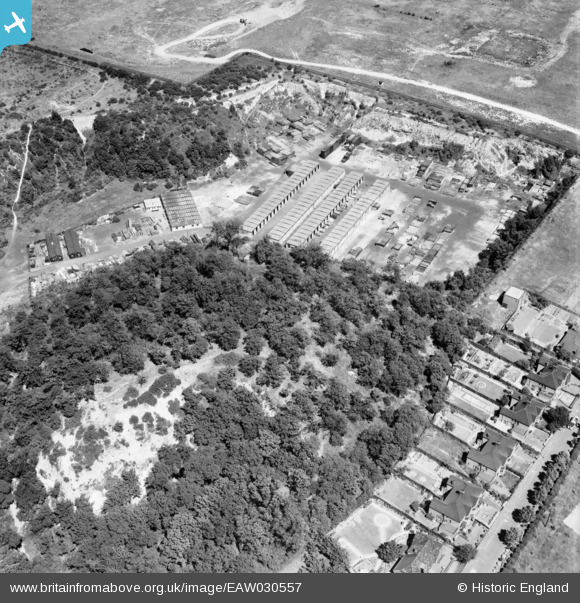
EAW030557 ENGLAND (1950). Beacon Hill, Beacon Hill, 1950
© Copyright OpenStreetMap contributors and licensed by the OpenStreetMap Foundation. 2026. Cartography is licensed as CC BY-SA.
Nearby Images (17)
Details
| Title | [EAW030557] Beacon Hill, Beacon Hill, 1950 |
| Reference | EAW030557 |
| Date | 28-June-1950 |
| Link | |
| Place name | BEACON HILL |
| Parish | |
| District | |
| Country | ENGLAND |
| Easting / Northing | 555827, 178226 |
| Longitude / Latitude | 0.24434487986661, 51.481008507752 |
| National Grid Reference | TQ558782 |
Pins
Be the first to add a comment to this image!


![[EAW030557] Beacon Hill, Beacon Hill, 1950](http://britainfromabove.org.uk/sites/all/libraries/aerofilms-images/public/100x100/EAW/030/EAW030557.jpg)
![[EAW030548] Purfleet Camp, Beacon Hill and environs, Beacon Hill, 1950](http://britainfromabove.org.uk/sites/all/libraries/aerofilms-images/public/100x100/EAW/030/EAW030548.jpg)
![[EAW030558] Prefabricated Buildings Works, Beacon Hill, 1950](http://britainfromabove.org.uk/sites/all/libraries/aerofilms-images/public/100x100/EAW/030/EAW030558.jpg)
![[EPW026351] Purfleet Chalk Quarry, Beacon Hill and surrounding countryside, Purfleet, 1929. This image has been affected by flare.](http://britainfromabove.org.uk/sites/all/libraries/aerofilms-images/public/100x100/EPW/026/EPW026351.jpg)
![[EAW030551] Beacon Hill and environs, Beacon Hill, from the south-east, 1950](http://britainfromabove.org.uk/sites/all/libraries/aerofilms-images/public/100x100/EAW/030/EAW030551.jpg)
![[EAW050478] Office building on London Road, Purfleet, 1953. This image was marked by Aerofilms Ltd for photo editing.](http://britainfromabove.org.uk/sites/all/libraries/aerofilms-images/public/100x100/EAW/050/EAW050478.jpg)
![[EAW030553] Beacon Hill and environs, Beacon Hill, 1950](http://britainfromabove.org.uk/sites/all/libraries/aerofilms-images/public/100x100/EAW/030/EAW030553.jpg)
![[EAW050479] Office building on London Road, Purfleet, 1953](http://britainfromabove.org.uk/sites/all/libraries/aerofilms-images/public/100x100/EAW/050/EAW050479.jpg)
![[EAW010056] Thames Board Mills and environs, Purfleet, 1947. This image was marked by Aerofilms Ltd for photo editing.](http://britainfromabove.org.uk/sites/all/libraries/aerofilms-images/public/100x100/EAW/010/EAW010056.jpg)
![[EAW050473] Office building on London Road, Purfleet, 1953. This image was marked by Aerofilms Ltd for photo editing.](http://britainfromabove.org.uk/sites/all/libraries/aerofilms-images/public/100x100/EAW/050/EAW050473.jpg)
![[EAW050480] Office building on London Road, Purfleet, 1953. This image was marked by Aerofilms Ltd for photo editing.](http://britainfromabove.org.uk/sites/all/libraries/aerofilms-images/public/100x100/EAW/050/EAW050480.jpg)
![[EAW050474] Office building on London Road, Purfleet, 1953. This image was marked by Aerofilms Ltd for photo editing.](http://britainfromabove.org.uk/sites/all/libraries/aerofilms-images/public/100x100/EAW/050/EAW050474.jpg)
![[EAW050476] Office building on London Road, Purfleet, 1953. This image was marked by Aerofilms Ltd for photo editing.](http://britainfromabove.org.uk/sites/all/libraries/aerofilms-images/public/100x100/EAW/050/EAW050476.jpg)
![[EAW050481] Office building on London Road, Purfleet, 1953](http://britainfromabove.org.uk/sites/all/libraries/aerofilms-images/public/100x100/EAW/050/EAW050481.jpg)
![[EAW050477] Office building on London Road, Purfleet, 1953. This image was marked by Aerofilms Ltd for photo editing.](http://britainfromabove.org.uk/sites/all/libraries/aerofilms-images/public/100x100/EAW/050/EAW050477.jpg)
![[EPW062019] Old chalk quarries above the railway station, Purfleet, 1939. This image has been produced from a print.](http://britainfromabove.org.uk/sites/all/libraries/aerofilms-images/public/100x100/EPW/062/EPW062019.jpg)
![[EAW050475] Office building on London Road at the junction with Mill Lane, Purfleet, 1953. This image was marked by Aerofilms Ltd for photo editing.](http://britainfromabove.org.uk/sites/all/libraries/aerofilms-images/public/100x100/EAW/050/EAW050475.jpg)