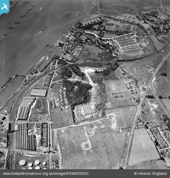
EAW030553 ENGLAND (1950). Beacon Hill and environs, Beacon Hill, 1950
© Copyright OpenStreetMap contributors and licensed by the OpenStreetMap Foundation. 2026. Cartography is licensed as CC BY-SA.
Nearby Images (15)
Details
| Title | [EAW030553] Beacon Hill and environs, Beacon Hill, 1950 |
| Reference | EAW030553 |
| Date | 28-June-1950 |
| Link | |
| Place name | BEACON HILL |
| Parish | |
| District | |
| Country | ENGLAND |
| Easting / Northing | 555655, 178298 |
| Longitude / Latitude | 0.24190137621575, 51.481702839229 |
| National Grid Reference | TQ557783 |
Pins
Be the first to add a comment to this image!


![[EAW030553] Beacon Hill and environs, Beacon Hill, 1950](http://britainfromabove.org.uk/sites/all/libraries/aerofilms-images/public/100x100/EAW/030/EAW030553.jpg)
![[EAW030551] Beacon Hill and environs, Beacon Hill, from the south-east, 1950](http://britainfromabove.org.uk/sites/all/libraries/aerofilms-images/public/100x100/EAW/030/EAW030551.jpg)
![[EAW030552] Purfleet and the River Thames, Beacon Hill, 1950](http://britainfromabove.org.uk/sites/all/libraries/aerofilms-images/public/100x100/EAW/030/EAW030552.jpg)
![[EPW062019] Old chalk quarries above the railway station, Purfleet, 1939. This image has been produced from a print.](http://britainfromabove.org.uk/sites/all/libraries/aerofilms-images/public/100x100/EPW/062/EPW062019.jpg)
![[EAW030554] Beacon Hill and environs, Beacon Hill, 1950](http://britainfromabove.org.uk/sites/all/libraries/aerofilms-images/public/100x100/EAW/030/EAW030554.jpg)
![[EAW030545] Beacon Hill and environs, Beacon Hill, 1950](http://britainfromabove.org.uk/sites/all/libraries/aerofilms-images/public/100x100/EAW/030/EAW030545.jpg)
![[EPW026351] Purfleet Chalk Quarry, Beacon Hill and surrounding countryside, Purfleet, 1929. This image has been affected by flare.](http://britainfromabove.org.uk/sites/all/libraries/aerofilms-images/public/100x100/EPW/026/EPW026351.jpg)
![[EAW030556] The Dipping, Beacon Hill and environs, Beacon Hill, 1950](http://britainfromabove.org.uk/sites/all/libraries/aerofilms-images/public/100x100/EAW/030/EAW030556.jpg)
![[EAW030546] Beacon Hill and environs, Beacon Hill, 1950](http://britainfromabove.org.uk/sites/all/libraries/aerofilms-images/public/100x100/EAW/030/EAW030546.jpg)
![[EAW030548] Purfleet Camp, Beacon Hill and environs, Beacon Hill, 1950](http://britainfromabove.org.uk/sites/all/libraries/aerofilms-images/public/100x100/EAW/030/EAW030548.jpg)
![[EAW030557] Beacon Hill, Beacon Hill, 1950](http://britainfromabove.org.uk/sites/all/libraries/aerofilms-images/public/100x100/EAW/030/EAW030557.jpg)
![[EAW030543] Tank Lane, London Road and the site of old chalk quarries at Botany, Beacon Hill, 1950](http://britainfromabove.org.uk/sites/all/libraries/aerofilms-images/public/100x100/EAW/030/EAW030543.jpg)
![[EAW030550] Purfleet Camp, Beacon Hill and environs, Beacon Hill, from the south-east, 1950](http://britainfromabove.org.uk/sites/all/libraries/aerofilms-images/public/100x100/EAW/030/EAW030550.jpg)
![[EAW030544] Tank Lane, London Road and the site of old chalk quarries at Botany, Beacon Hill, 1950](http://britainfromabove.org.uk/sites/all/libraries/aerofilms-images/public/100x100/EAW/030/EAW030544.jpg)
![[EAW030558] Prefabricated Buildings Works, Beacon Hill, 1950](http://britainfromabove.org.uk/sites/all/libraries/aerofilms-images/public/100x100/EAW/030/EAW030558.jpg)