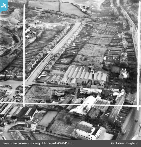
EAW041435 ENGLAND (1951). Croft Mill and Sandhurst Avenue, Mansfield, 1951. This image has been produced from a print marked by Aerofilms Ltd for photo editing.
© Copyright OpenStreetMap contributors and licensed by the OpenStreetMap Foundation. 2024. Cartography is licensed as CC BY-SA.
Nearby Images (9)
Details
| Title | [EAW041435] Croft Mill and Sandhurst Avenue, Mansfield, 1951. This image has been produced from a print marked by Aerofilms Ltd for photo editing. |
| Reference | EAW041435 |
| Date | 27-December-1951 |
| Link | |
| Place name | MANSFIELD |
| Parish | |
| District | |
| Country | ENGLAND |
| Easting / Northing | 453943, 359770 |
| Longitude / Latitude | -1.1936572906928, 53.132064649697 |
| National Grid Reference | SK539598 |
Pins
 LindaP |
Saturday 16th of January 2021 10:48:58 PM |


![[EAW041435] Croft Mill and Sandhurst Avenue, Mansfield, 1951. This image has been produced from a print marked by Aerofilms Ltd for photo editing.](http://britainfromabove.org.uk/sites/all/libraries/aerofilms-images/public/100x100/EAW/041/EAW041435.jpg)
![[EAW041432] Croft Mill, Mansfield, 1951. This image has been produced from a print marked by Aerofilms Ltd for photo editing.](http://britainfromabove.org.uk/sites/all/libraries/aerofilms-images/public/100x100/EAW/041/EAW041432.jpg)
![[EAW041434] Croft Mill off Forest Road, Mansfield, 1951. This image has been produced from a print marked by Aerofilms Ltd for photo editing.](http://britainfromabove.org.uk/sites/all/libraries/aerofilms-images/public/100x100/EAW/041/EAW041434.jpg)
![[EAW041427] Croft Mill and Sandhurst Avenue, Mansfield, 1951. This image has been produced from a print marked by Aerofilms Ltd for photo editing.](http://britainfromabove.org.uk/sites/all/libraries/aerofilms-images/public/100x100/EAW/041/EAW041427.jpg)
![[EAW041431] Croft Mill, Mansfield, 1951. This image has been produced from a print marked by Aerofilms Ltd for photo editing.](http://britainfromabove.org.uk/sites/all/libraries/aerofilms-images/public/100x100/EAW/041/EAW041431.jpg)
![[EAW041429] Croft Mill, Mansfield, 1951. This image has been produced from a print marked by Aerofilms Ltd for photo editing.](http://britainfromabove.org.uk/sites/all/libraries/aerofilms-images/public/100x100/EAW/041/EAW041429.jpg)
![[EAW041430] Croft Mill, Mansfield, 1951. This image has been produced from a print marked by Aerofilms Ltd for photo editing.](http://britainfromabove.org.uk/sites/all/libraries/aerofilms-images/public/100x100/EAW/041/EAW041430.jpg)
![[EAW041428] Croft Mill, Mansfield, 1951. This image has been produced from a print marked by Aerofilms Ltd for photo editing.](http://britainfromabove.org.uk/sites/all/libraries/aerofilms-images/public/100x100/EAW/041/EAW041428.jpg)
![[EAW041433] Croft Mill, Nottingham Road and environs, Mansfield, 1951. This image has been produced from a print marked by Aerofilms Ltd for photo editing.](http://britainfromabove.org.uk/sites/all/libraries/aerofilms-images/public/100x100/EAW/041/EAW041433.jpg)