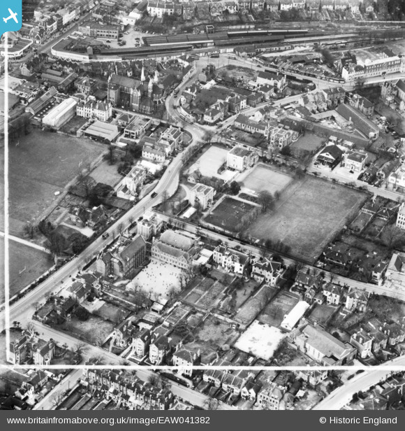
EAW041382 ENGLAND (1951). Croydon High School for Girls, Croydon, 1951. This image has been produced from a print marked by Aerofilms Ltd for photo editing.
© Copyright OpenStreetMap contributors and licensed by the OpenStreetMap Foundation. 2026. Cartography is licensed as CC BY-SA.
Nearby Images (20)
Details
| Title | [EAW041382] Croydon High School for Girls, Croydon, 1951. This image has been produced from a print marked by Aerofilms Ltd for photo editing. |
| Reference | EAW041382 |
| Date | 22-November-1951 |
| Link | |
| Place name | CROYDON |
| Parish | |
| District | |
| Country | ENGLAND |
| Easting / Northing | 532420, 166026 |
| Longitude / Latitude | -0.097125053058602, 51.377325092731 |
| National Grid Reference | TQ324660 |
Pins

Nowy Paul |
Saturday 17th of February 2018 11:25:18 AM | |
All very interesting but what is its relevance to this photo. |

brianbeckett |
Thursday 25th of June 2020 03:58:01 PM |


![[EAW041382] Croydon High School for Girls, Croydon, 1951. This image has been produced from a print marked by Aerofilms Ltd for photo editing.](http://britainfromabove.org.uk/sites/all/libraries/aerofilms-images/public/100x100/EAW/041/EAW041382.jpg)
![[EAW042971] Croydon High School for Girls at the junction of Wellesley Road and Sydenham Road, Croydon, 1952. This image was marked by Aerofilms Ltd for photo editing.](http://britainfromabove.org.uk/sites/all/libraries/aerofilms-images/public/100x100/EAW/042/EAW042971.jpg)
![[EAW041376] Croydon High School for Girls, Croydon, 1951. This image has been produced from a print marked by Aerofilms Ltd for photo editing.](http://britainfromabove.org.uk/sites/all/libraries/aerofilms-images/public/100x100/EAW/041/EAW041376.jpg)
![[EAW041378] Croydon High School for Girls, Croydon, 1951. This image has been produced from a print marked by Aerofilms Ltd for photo editing.](http://britainfromabove.org.uk/sites/all/libraries/aerofilms-images/public/100x100/EAW/041/EAW041378.jpg)
![[EAW042964] Croydon High School for Girls at the junction of Wellesley Road and Sydenham Road, Croydon, 1952. This image was marked by Aerofilms Ltd for photo editing.](http://britainfromabove.org.uk/sites/all/libraries/aerofilms-images/public/100x100/EAW/042/EAW042964.jpg)
![[EAW042967] Croydon High School for Girls at the junction of Wellesley Road and Sydenham Road, Croydon, 1952. This image was marked by Aerofilms Ltd for photo editing.](http://britainfromabove.org.uk/sites/all/libraries/aerofilms-images/public/100x100/EAW/042/EAW042967.jpg)
![[EAW041377] Croydon High School for Girls, Croydon, 1951. This image has been produced from a print marked by Aerofilms Ltd for photo editing.](http://britainfromabove.org.uk/sites/all/libraries/aerofilms-images/public/100x100/EAW/041/EAW041377.jpg)
![[EAW041379] Croydon High School for Girls, Croydon, 1951. This image has been produced from a print marked by Aerofilms Ltd for photo editing.](http://britainfromabove.org.uk/sites/all/libraries/aerofilms-images/public/100x100/EAW/041/EAW041379.jpg)
![[EAW041383] Croydon High School for Girls, Croydon, 1951. This image has been produced from a print marked by Aerofilms Ltd for photo editing.](http://britainfromabove.org.uk/sites/all/libraries/aerofilms-images/public/100x100/EAW/041/EAW041383.jpg)
![[EAW042970] Croydon High School for Girls, Sydenham Road and environs, Croydon, 1952. This image was marked by Aerofilms Ltd for photo editing.](http://britainfromabove.org.uk/sites/all/libraries/aerofilms-images/public/100x100/EAW/042/EAW042970.jpg)
![[EAW042972] Croydon High School for Girls and Wellesley Road, Croydon, 1952. This image was marked by Aerofilms Ltd for photo editing.](http://britainfromabove.org.uk/sites/all/libraries/aerofilms-images/public/100x100/EAW/042/EAW042972.jpg)
![[EAW041381] Croydon High School for Girls, Croydon, 1951. This image has been produced from a print marked by Aerofilms Ltd for photo editing.](http://britainfromabove.org.uk/sites/all/libraries/aerofilms-images/public/100x100/EAW/041/EAW041381.jpg)
![[EAW042969] Croydon High School for Girls at the junction of Wellesley Road and Sydenham Road, Croydon, 1952. This image was marked by Aerofilms Ltd for photo editing.](http://britainfromabove.org.uk/sites/all/libraries/aerofilms-images/public/100x100/EAW/042/EAW042969.jpg)
![[EAW042968] Croydon High School for Girls at the junction of Wellesley Road and Sydenham Road, Croydon, 1952. This image was marked by Aerofilms Ltd for photo editing.](http://britainfromabove.org.uk/sites/all/libraries/aerofilms-images/public/100x100/EAW/042/EAW042968.jpg)
![[EAW042965] Croydon High School for Girls at the junction of Wellesley Road and Sydenham Road and environs, Croydon, 1952. This image was marked by Aerofilms Ltd for photo editing.](http://britainfromabove.org.uk/sites/all/libraries/aerofilms-images/public/100x100/EAW/042/EAW042965.jpg)
![[EAW041380] Croydon High School for Girls, Croydon, 1951. This image was marked by Aerofilms Ltd for photo editing.](http://britainfromabove.org.uk/sites/all/libraries/aerofilms-images/public/100x100/EAW/041/EAW041380.jpg)
![[EAW042966] Croydon High School for Girls at the junction of Wellesley Road and Sydenham Road and environs, Croydon, 1952. This image was marked by Aerofilms Ltd for photo editing.](http://britainfromabove.org.uk/sites/all/libraries/aerofilms-images/public/100x100/EAW/042/EAW042966.jpg)
![[EAW042973] Croydon High School for Girls at the junction of Wellesley Road and Sydenham Road and environs, Croydon, 1952. This image was marked by Aerofilms Ltd for photo editing.](http://britainfromabove.org.uk/sites/all/libraries/aerofilms-images/public/100x100/EAW/042/EAW042973.jpg)
![[EAW047594] East Croydon Railway Station and environs, Croydon, 1952](http://britainfromabove.org.uk/sites/all/libraries/aerofilms-images/public/100x100/EAW/047/EAW047594.jpg)
![[EPW056621] St Michael and All Angels' Church and the town centre, Croydon, 1938](http://britainfromabove.org.uk/sites/all/libraries/aerofilms-images/public/100x100/EPW/056/EPW056621.jpg)