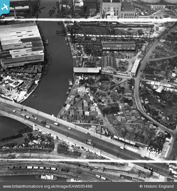
EAW035488 ENGLAND (1951). Crown Wharf, Canning Town, 1951. This image has been produced from a print marked by Aerofilms Ltd for photo editing.
© Copyright OpenStreetMap contributors and licensed by the OpenStreetMap Foundation. 2026. Cartography is licensed as CC BY-SA.
Nearby Images (24)
Details
| Title | [EAW035488] Crown Wharf, Canning Town, 1951. This image has been produced from a print marked by Aerofilms Ltd for photo editing. |
| Reference | EAW035488 |
| Date | 17-April-1951 |
| Link | |
| Place name | CANNING TOWN |
| Parish | |
| District | |
| Country | ENGLAND |
| Easting / Northing | 539166, 181522 |
| Longitude / Latitude | 0.005847648278996, 51.51497525104 |
| National Grid Reference | TQ392815 |
Pins
Be the first to add a comment to this image!
User Comment Contributions
Crown Wharf, Bow Creek, 17/02/2015. Looking north west. |

Class31 |
Saturday 28th of February 2015 08:06:15 AM |


![[EAW035488] Crown Wharf, Canning Town, 1951. This image has been produced from a print marked by Aerofilms Ltd for photo editing.](http://britainfromabove.org.uk/sites/all/libraries/aerofilms-images/public/100x100/EAW/035/EAW035488.jpg)
![[EAW035489] Crown Wharf and Commercial Wharf on the River Lea, Canning Town, 1951. This image has been produced from a print marked by Aerofilms Ltd for photo editing.](http://britainfromabove.org.uk/sites/all/libraries/aerofilms-images/public/100x100/EAW/035/EAW035489.jpg)
![[EAW035487] Crown Wharf, Canning Town, 1951. This image has been produced from a print marked by Aerofilms Ltd for photo editing.](http://britainfromabove.org.uk/sites/all/libraries/aerofilms-images/public/100x100/EAW/035/EAW035487.jpg)
![[EAW035485] Crown Wharf, Canning Town, 1951. This image has been produced from a print marked by Aerofilms Ltd for photo editing.](http://britainfromabove.org.uk/sites/all/libraries/aerofilms-images/public/100x100/EAW/035/EAW035485.jpg)
![[EAW035486] Crown Wharf, Canning Town, 1951. This image has been produced from a print.](http://britainfromabove.org.uk/sites/all/libraries/aerofilms-images/public/100x100/EAW/035/EAW035486.jpg)
![[EAW035490] Crown Wharf, Canning Town, 1951. This image has been produced from a print marked by Aerofilms Ltd for photo editing.](http://britainfromabove.org.uk/sites/all/libraries/aerofilms-images/public/100x100/EAW/035/EAW035490.jpg)
![[EAW035493] Crown Wharf, Canning Town, 1951. This image has been produced from a print marked by Aerofilms Ltd for photo editing.](http://britainfromabove.org.uk/sites/all/libraries/aerofilms-images/public/100x100/EAW/035/EAW035493.jpg)
![[EAW035492] Crown Wharf, Canning Town, 1951. This image has been produced from a print marked by Aerofilms Ltd for photo editing.](http://britainfromabove.org.uk/sites/all/libraries/aerofilms-images/public/100x100/EAW/035/EAW035492.jpg)
![[EAW035491] Crown Wharf, Stephenson Street and environs, Canning Town, 1951. This image has been produced from a print marked by Aerofilms Ltd for photo editing.](http://britainfromabove.org.uk/sites/all/libraries/aerofilms-images/public/100x100/EAW/035/EAW035491.jpg)
![[EAW037178] George Cohen Sons and Co Ltd Coborn Metal Works and the W.W. Howard Brothers and Co Ltd Timber Yard at Commercial Wharf, Canning Town, 1951. This image has been produced from a print marked by Aerofilms Ltd for photo editing.](http://britainfromabove.org.uk/sites/all/libraries/aerofilms-images/public/100x100/EAW/037/EAW037178.jpg)
![[EAW037186] W.W. Howard Brothers and Co Ltd Timber Yard at Commercial Wharf, South Bromley, 1951. This image has been produced from a print marked by Aerofilms Ltd for photo editing.](http://britainfromabove.org.uk/sites/all/libraries/aerofilms-images/public/100x100/EAW/037/EAW037186.jpg)
![[EAW035479] East India Dock Road and Commercial Wharf on the River Lea, South Bromley, 1951. This image has been produced from a print marked by Aerofilms Ltd for photo editing.](http://britainfromabove.org.uk/sites/all/libraries/aerofilms-images/public/100x100/EAW/035/EAW035479.jpg)
![[EAW035478] Commercial Wharf on the River Lea, South Bromley, 1951. This image has been produced from a print marked by Aerofilms Ltd for photo editing.](http://britainfromabove.org.uk/sites/all/libraries/aerofilms-images/public/100x100/EAW/035/EAW035478.jpg)
![[EAW037184] W.W. Howard Brothers and Co Ltd Timber Yard at Commercial Wharf, South Bromley, 1951. This image has been produced from a print marked by Aerofilms Ltd for photo editing.](http://britainfromabove.org.uk/sites/all/libraries/aerofilms-images/public/100x100/EAW/037/EAW037184.jpg)
![[EAW037177] W.W. Howard Brothers and Co Ltd Timber Yard at Commercial Wharf and environs, South Bromley, 1951. This image has been produced from a print marked by Aerofilms Ltd for photo editing.](http://britainfromabove.org.uk/sites/all/libraries/aerofilms-images/public/100x100/EAW/037/EAW037177.jpg)
![[EAW037180] W.W. Howard Brothers and Co Ltd Timber Yard at Commercial Wharf, South Bromley, 1951. This image has been produced from a print marked by Aerofilms Ltd for photo editing.](http://britainfromabove.org.uk/sites/all/libraries/aerofilms-images/public/100x100/EAW/037/EAW037180.jpg)
![[EAW037181] W.W. Howard Brothers and Co Ltd Timber Yard at Commercial Wharf, South Bromley, 1951. This image has been produced from a print marked by Aerofilms Ltd for photo editing.](http://britainfromabove.org.uk/sites/all/libraries/aerofilms-images/public/100x100/EAW/037/EAW037181.jpg)
![[EAW037183] W.W. Howard Brothers and Co Ltd Timber Yard at Commercial Wharf, South Bromley, 1951. This image has been produced from a print marked by Aerofilms Ltd for photo editing.](http://britainfromabove.org.uk/sites/all/libraries/aerofilms-images/public/100x100/EAW/037/EAW037183.jpg)
![[EAW037185] W.W. Howard Brothers and Co Ltd Timber Yard at Commercial Wharf, South Bromley, 1951. This image has been produced from a print marked by Aerofilms Ltd for photo editing.](http://britainfromabove.org.uk/sites/all/libraries/aerofilms-images/public/100x100/EAW/037/EAW037185.jpg)
![[EAW035481] East India Dock Road, Oban Street, Moness Street, Portree Street and Commercial Wharf on the River Lea, South Bromley, 1951. This image has been produced from a print marked by Aerofilms Ltd for photo editing.](http://britainfromabove.org.uk/sites/all/libraries/aerofilms-images/public/100x100/EAW/035/EAW035481.jpg)
![[EAW035482] East India Dock Road, Oban Street, Moness Street, Portree Street and Commercial Wharf on the River Lea, South Bromley, 1951. This image has been produced from a print marked by Aerofilms Ltd for photo editing.](http://britainfromabove.org.uk/sites/all/libraries/aerofilms-images/public/100x100/EAW/035/EAW035482.jpg)
![[EAW035484] East India Dock Road, Oban Street, Moness Street, Portree Street and Commercial Wharf on the River Lea, South Bromley, 1951. This image has been produced from a print marked by Aerofilms Ltd for photo editing.](http://britainfromabove.org.uk/sites/all/libraries/aerofilms-images/public/100x100/EAW/035/EAW035484.jpg)
![[EAW035483] Oban Street, Moness Street, Portree Street and Commercial Wharf on the River Lea, South Bromley, 1951. This image has been produced from a print marked by Aerofilms Ltd for photo editing.](http://britainfromabove.org.uk/sites/all/libraries/aerofilms-images/public/100x100/EAW/035/EAW035483.jpg)
![[EAW035477] Oban Street, Moness Street, Portree Street and Commercial Wharf on the River Lea, South Bromley, 1951. This image has been produced from a print marked by Aerofilms Ltd for photo editing.](http://britainfromabove.org.uk/sites/all/libraries/aerofilms-images/public/100x100/EAW/035/EAW035477.jpg)