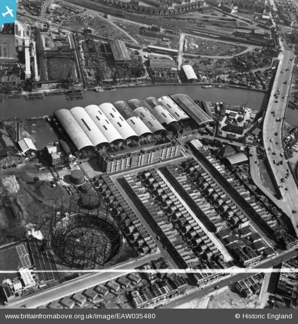
EAW035480 ENGLAND (1951). Oban Street, Moness Street, Portree Street and Commercial Wharf on the River Lea, South Bromley, 1951. This image has been produced from a print marked by Aerofilms Ltd for photo editing.
© Copyright OpenStreetMap contributors and licensed by the OpenStreetMap Foundation. 2026. Cartography is licensed as CC BY-SA.
Nearby Images (24)
Details
| Title | [EAW035480] Oban Street, Moness Street, Portree Street and Commercial Wharf on the River Lea, South Bromley, 1951. This image has been produced from a print marked by Aerofilms Ltd for photo editing. |
| Reference | EAW035480 |
| Date | 17-April-1951 |
| Link | |
| Place name | SOUTH BROMLEY |
| Parish | |
| District | |
| Country | ENGLAND |
| Easting / Northing | 538910, 181479 |
| Longitude / Latitude | 0.0021433089689371, 51.514651825251 |
| National Grid Reference | TQ389815 |
Pins

Post-war prefabs |
Thursday 25th of February 2021 09:00:09 AM |


![[EAW035480] Oban Street, Moness Street, Portree Street and Commercial Wharf on the River Lea, South Bromley, 1951. This image has been produced from a print marked by Aerofilms Ltd for photo editing.](http://britainfromabove.org.uk/sites/all/libraries/aerofilms-images/public/100x100/EAW/035/EAW035480.jpg)
![[EAW037185] W.W. Howard Brothers and Co Ltd Timber Yard at Commercial Wharf, South Bromley, 1951. This image has been produced from a print marked by Aerofilms Ltd for photo editing.](http://britainfromabove.org.uk/sites/all/libraries/aerofilms-images/public/100x100/EAW/037/EAW037185.jpg)
![[EAW035483] Oban Street, Moness Street, Portree Street and Commercial Wharf on the River Lea, South Bromley, 1951. This image has been produced from a print marked by Aerofilms Ltd for photo editing.](http://britainfromabove.org.uk/sites/all/libraries/aerofilms-images/public/100x100/EAW/035/EAW035483.jpg)
![[EAW037183] W.W. Howard Brothers and Co Ltd Timber Yard at Commercial Wharf, South Bromley, 1951. This image has been produced from a print marked by Aerofilms Ltd for photo editing.](http://britainfromabove.org.uk/sites/all/libraries/aerofilms-images/public/100x100/EAW/037/EAW037183.jpg)
![[EAW035484] East India Dock Road, Oban Street, Moness Street, Portree Street and Commercial Wharf on the River Lea, South Bromley, 1951. This image has been produced from a print marked by Aerofilms Ltd for photo editing.](http://britainfromabove.org.uk/sites/all/libraries/aerofilms-images/public/100x100/EAW/035/EAW035484.jpg)
![[EAW035482] East India Dock Road, Oban Street, Moness Street, Portree Street and Commercial Wharf on the River Lea, South Bromley, 1951. This image has been produced from a print marked by Aerofilms Ltd for photo editing.](http://britainfromabove.org.uk/sites/all/libraries/aerofilms-images/public/100x100/EAW/035/EAW035482.jpg)
![[EAW035477] Oban Street, Moness Street, Portree Street and Commercial Wharf on the River Lea, South Bromley, 1951. This image has been produced from a print marked by Aerofilms Ltd for photo editing.](http://britainfromabove.org.uk/sites/all/libraries/aerofilms-images/public/100x100/EAW/035/EAW035477.jpg)
![[EAW037181] W.W. Howard Brothers and Co Ltd Timber Yard at Commercial Wharf, South Bromley, 1951. This image has been produced from a print marked by Aerofilms Ltd for photo editing.](http://britainfromabove.org.uk/sites/all/libraries/aerofilms-images/public/100x100/EAW/037/EAW037181.jpg)
![[EAW035481] East India Dock Road, Oban Street, Moness Street, Portree Street and Commercial Wharf on the River Lea, South Bromley, 1951. This image has been produced from a print marked by Aerofilms Ltd for photo editing.](http://britainfromabove.org.uk/sites/all/libraries/aerofilms-images/public/100x100/EAW/035/EAW035481.jpg)
![[EAW035478] Commercial Wharf on the River Lea, South Bromley, 1951. This image has been produced from a print marked by Aerofilms Ltd for photo editing.](http://britainfromabove.org.uk/sites/all/libraries/aerofilms-images/public/100x100/EAW/035/EAW035478.jpg)
![[EAW035479] East India Dock Road and Commercial Wharf on the River Lea, South Bromley, 1951. This image has been produced from a print marked by Aerofilms Ltd for photo editing.](http://britainfromabove.org.uk/sites/all/libraries/aerofilms-images/public/100x100/EAW/035/EAW035479.jpg)
![[EAW037180] W.W. Howard Brothers and Co Ltd Timber Yard at Commercial Wharf, South Bromley, 1951. This image has been produced from a print marked by Aerofilms Ltd for photo editing.](http://britainfromabove.org.uk/sites/all/libraries/aerofilms-images/public/100x100/EAW/037/EAW037180.jpg)
![[EAW037177] W.W. Howard Brothers and Co Ltd Timber Yard at Commercial Wharf and environs, South Bromley, 1951. This image has been produced from a print marked by Aerofilms Ltd for photo editing.](http://britainfromabove.org.uk/sites/all/libraries/aerofilms-images/public/100x100/EAW/037/EAW037177.jpg)
![[EAW037184] W.W. Howard Brothers and Co Ltd Timber Yard at Commercial Wharf, South Bromley, 1951. This image has been produced from a print marked by Aerofilms Ltd for photo editing.](http://britainfromabove.org.uk/sites/all/libraries/aerofilms-images/public/100x100/EAW/037/EAW037184.jpg)
![[EAW037179] W.W. Howard Brothers and Co Ltd Timber Yard at Commercial Wharf, South Bromley, 1951. This image has been produced from a print marked by Aerofilms Ltd for photo editing.](http://britainfromabove.org.uk/sites/all/libraries/aerofilms-images/public/100x100/EAW/037/EAW037179.jpg)
![[EAW037186] W.W. Howard Brothers and Co Ltd Timber Yard at Commercial Wharf, South Bromley, 1951. This image has been produced from a print marked by Aerofilms Ltd for photo editing.](http://britainfromabove.org.uk/sites/all/libraries/aerofilms-images/public/100x100/EAW/037/EAW037186.jpg)
![[EAW035489] Crown Wharf and Commercial Wharf on the River Lea, Canning Town, 1951. This image has been produced from a print marked by Aerofilms Ltd for photo editing.](http://britainfromabove.org.uk/sites/all/libraries/aerofilms-images/public/100x100/EAW/035/EAW035489.jpg)
![[EAW037178] George Cohen Sons and Co Ltd Coborn Metal Works and the W.W. Howard Brothers and Co Ltd Timber Yard at Commercial Wharf, Canning Town, 1951. This image has been produced from a print marked by Aerofilms Ltd for photo editing.](http://britainfromabove.org.uk/sites/all/libraries/aerofilms-images/public/100x100/EAW/037/EAW037178.jpg)
![[EAW035487] Crown Wharf, Canning Town, 1951. This image has been produced from a print marked by Aerofilms Ltd for photo editing.](http://britainfromabove.org.uk/sites/all/libraries/aerofilms-images/public/100x100/EAW/035/EAW035487.jpg)
![[EAW035485] Crown Wharf, Canning Town, 1951. This image has been produced from a print marked by Aerofilms Ltd for photo editing.](http://britainfromabove.org.uk/sites/all/libraries/aerofilms-images/public/100x100/EAW/035/EAW035485.jpg)
![[EAW035490] Crown Wharf, Canning Town, 1951. This image has been produced from a print marked by Aerofilms Ltd for photo editing.](http://britainfromabove.org.uk/sites/all/libraries/aerofilms-images/public/100x100/EAW/035/EAW035490.jpg)
![[EAW035492] Crown Wharf, Canning Town, 1951. This image has been produced from a print marked by Aerofilms Ltd for photo editing.](http://britainfromabove.org.uk/sites/all/libraries/aerofilms-images/public/100x100/EAW/035/EAW035492.jpg)
![[EAW035504] The Limmo Peninsula, Goodluck Hope/Leamouth Peninsula and environs, Canning Town, 1951. This image has been produced from a print.](http://britainfromabove.org.uk/sites/all/libraries/aerofilms-images/public/100x100/EAW/035/EAW035504.jpg)
![[EAW035502] The Limmo Peninsula, Goodluck Hope/Leamouth Peninsula and environs, Canning Town, 1951. This image has been produced from a print.](http://britainfromabove.org.uk/sites/all/libraries/aerofilms-images/public/100x100/EAW/035/EAW035502.jpg)