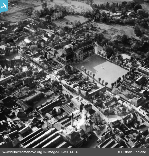
EAW034104 ENGLAND (1950). Church Street and the Abbey Church of St Mary and St Ethelfraeda, Romsey, 1950
© Copyright OpenStreetMap contributors and licensed by the OpenStreetMap Foundation. 2026. Cartography is licensed as CC BY-SA.
Nearby Images (22)
Details
| Title | [EAW034104] Church Street and the Abbey Church of St Mary and St Ethelfraeda, Romsey, 1950 |
| Reference | EAW034104 |
| Date | 25-October-1950 |
| Link | |
| Place name | ROMSEY |
| Parish | ROMSEY |
| District | |
| Country | ENGLAND |
| Easting / Northing | 435135, 121302 |
| Longitude / Latitude | -1.4993482182028, 50.989501927042 |
| National Grid Reference | SU351213 |
Pins

Class31 |
Monday 20th of October 2014 09:46:27 AM |
User Comment Contributions
The Abbey Church of St Mary and St Ethelfraeda, Romsey, 19/10/2014 |

Class31 |
Monday 20th of October 2014 09:47:04 AM |


![[EAW034104] Church Street and the Abbey Church of St Mary and St Ethelfraeda, Romsey, 1950](http://britainfromabove.org.uk/sites/all/libraries/aerofilms-images/public/100x100/EAW/034/EAW034104.jpg)
![[EAW034098] The Abbey Church of St Mary and St Ethelflaeda, Romsey, 1950. This image has been produced from a print.](http://britainfromabove.org.uk/sites/all/libraries/aerofilms-images/public/100x100/EAW/034/EAW034098.jpg)
![[EAW034099] The Abbey Church of St Mary and St Ethelflaeda, Romsey, 1950. This image has been produced from a print.](http://britainfromabove.org.uk/sites/all/libraries/aerofilms-images/public/100x100/EAW/034/EAW034099.jpg)
![[EAW034100] The Abbey Church of St Mary and St Ethelflaeda, Romsey, 1950](http://britainfromabove.org.uk/sites/all/libraries/aerofilms-images/public/100x100/EAW/034/EAW034100.jpg)
![[EAW034106] The Abbey Church of St Mary and St Ethelfraeda and the town centre, Romsey, 1950. This image has been produced from a damaged negative.](http://britainfromabove.org.uk/sites/all/libraries/aerofilms-images/public/100x100/EAW/034/EAW034106.jpg)
![[EPW013639] The Abbey Church of St Mary, Romsey, 1925. This image has been produced from a copy-negative.](http://britainfromabove.org.uk/sites/all/libraries/aerofilms-images/public/100x100/EPW/013/EPW013639.jpg)
![[EAW034101] The Abbey Church of St Mary and St Ethelflaeda, Romsey, 1950](http://britainfromabove.org.uk/sites/all/libraries/aerofilms-images/public/100x100/EAW/034/EAW034101.jpg)
![[EPW032326] The Abbey Church of St Mary and Strong's Brewery, Romsey, 1930](http://britainfromabove.org.uk/sites/all/libraries/aerofilms-images/public/100x100/EPW/032/EPW032326.jpg)
![[EAW034105] The Market Place and the Abbey Church of St Mary and St Ethelfraeda, Romsey, 1950](http://britainfromabove.org.uk/sites/all/libraries/aerofilms-images/public/100x100/EAW/034/EAW034105.jpg)
![[EPW013636] The Abbey Church of St Mary and the town centre, Romsey, 1925. This image has been produced from a copy-negative.](http://britainfromabove.org.uk/sites/all/libraries/aerofilms-images/public/100x100/EPW/013/EPW013636.jpg)
![[EAW034097] The Abbey Church of St Mary and St Ethelflaeda, Romsey, 1950. This image has been produced from a print.](http://britainfromabove.org.uk/sites/all/libraries/aerofilms-images/public/100x100/EAW/034/EAW034097.jpg)
![[EAW034103] The town, Romsey, 1950](http://britainfromabove.org.uk/sites/all/libraries/aerofilms-images/public/100x100/EAW/034/EAW034103.jpg)
![[EPW032325] The Abbey Church of St Mary and the town centre, Romsey, 1930](http://britainfromabove.org.uk/sites/all/libraries/aerofilms-images/public/100x100/EPW/032/EPW032325.jpg)
![[EPW013640] The Abbey Church of St Mary and the town, Romsey, 1925. This image has been produced from a print.](http://britainfromabove.org.uk/sites/all/libraries/aerofilms-images/public/100x100/EPW/013/EPW013640.jpg)
![[EPW032327] The Abbey Church of St Mary, Strong's Brewery and the town centre, Romsey, 1930](http://britainfromabove.org.uk/sites/all/libraries/aerofilms-images/public/100x100/EPW/032/EPW032327.jpg)
![[EPW013638] The town centre, Romsey, 1925. This image has been produced from a copy-negative.](http://britainfromabove.org.uk/sites/all/libraries/aerofilms-images/public/100x100/EPW/013/EPW013638.jpg)
![[EPW032328] The Abbey Church of St Mary, Strong's Brewery and the town, Romsey, 1930](http://britainfromabove.org.uk/sites/all/libraries/aerofilms-images/public/100x100/EPW/032/EPW032328.jpg)
![[EPW013635] The town centre, Romsey, 1925. This image has been produced from a copy-negative.](http://britainfromabove.org.uk/sites/all/libraries/aerofilms-images/public/100x100/EPW/013/EPW013635.jpg)
![[EAW034102] The town, Romsey, 1950](http://britainfromabove.org.uk/sites/all/libraries/aerofilms-images/public/100x100/EAW/034/EAW034102.jpg)
![[EPW033733] Cherville Street and the town, Romsey, 1930](http://britainfromabove.org.uk/sites/all/libraries/aerofilms-images/public/100x100/EPW/033/EPW033733.jpg)
![[EPW056976] The town centre, Romsey, 1938](http://britainfromabove.org.uk/sites/all/libraries/aerofilms-images/public/100x100/EPW/056/EPW056976.jpg)
![[EPW013641] The town, Romsey, 1925. This image has been produced from a print.](http://britainfromabove.org.uk/sites/all/libraries/aerofilms-images/public/100x100/EPW/013/EPW013641.jpg)