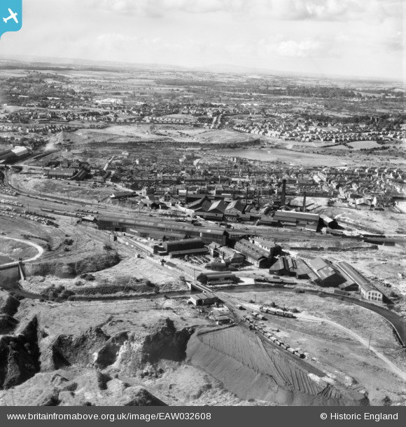
EAW032608 ENGLAND (1950). Hill and Smith Ltd Brierleyhill Iron Works and environs, Hart's Hill, from the south-east, 1950
© Copyright OpenStreetMap contributors and licensed by the OpenStreetMap Foundation. 2026. Cartography is licensed as CC BY-SA.
Nearby Images (15)
Details
| Title | [EAW032608] Hill and Smith Ltd Brierleyhill Iron Works and environs, Hart's Hill, from the south-east, 1950 |
| Reference | EAW032608 |
| Date | 18-September-1950 |
| Link | |
| Place name | HART'S HILL |
| Parish | |
| District | |
| Country | ENGLAND |
| Easting / Northing | 392608, 288019 |
| Longitude / Latitude | -2.1088781002797, 52.489667093122 |
| National Grid Reference | SO926880 |
Pins

black country history hunter |
Monday 18th of June 2018 06:02:53 PM | |

black country history hunter |
Monday 18th of June 2018 05:52:19 PM | |

black country history hunter |
Monday 18th of June 2018 05:45:25 PM | |

black country history hunter |
Saturday 16th of June 2018 08:35:04 PM |


![[EAW032608] Hill and Smith Ltd Brierleyhill Iron Works and environs, Hart's Hill, from the south-east, 1950](http://britainfromabove.org.uk/sites/all/libraries/aerofilms-images/public/100x100/EAW/032/EAW032608.jpg)
![[EAW032603] Hill and Smith Ltd Brierleyhill Iron Works and environs, Hart's Hill, from the east, 1950. This image was marked by Aerofilms Ltd for photo editing.](http://britainfromabove.org.uk/sites/all/libraries/aerofilms-images/public/100x100/EAW/032/EAW032603.jpg)
![[EAW032604] Hill and Smith Ltd Brierleyhill Iron Works, Hart's Hill, 1950. This image was marked by Aerofilms Ltd for photo editing.](http://britainfromabove.org.uk/sites/all/libraries/aerofilms-images/public/100x100/EAW/032/EAW032604.jpg)
![[EAW032605] Hill and Smith Ltd Brierleyhill Iron Works, Hart's Hill, 1950. This image was marked by Aerofilms Ltd for photo editing.](http://britainfromabove.org.uk/sites/all/libraries/aerofilms-images/public/100x100/EAW/032/EAW032605.jpg)
![[EAW032600] Hill and Smith Ltd Brierleyhill Iron Works, the Dudley Canal and environs, Hart's Hill, from the south, 1950](http://britainfromabove.org.uk/sites/all/libraries/aerofilms-images/public/100x100/EAW/032/EAW032600.jpg)
![[EAW032602] Hill and Smith Ltd Brierleyhill Iron Works and environs, Hart's Hill, 1950. This image was marked by Aerofilms Ltd for photo editing.](http://britainfromabove.org.uk/sites/all/libraries/aerofilms-images/public/100x100/EAW/032/EAW032602.jpg)
![[EAW032606] Hill and Smith Ltd Brierleyhill Iron Works and environs, Hart's Hill, 1950](http://britainfromabove.org.uk/sites/all/libraries/aerofilms-images/public/100x100/EAW/032/EAW032606.jpg)
![[EAW032607] Hill and Smith Ltd Brierleyhill Iron Works, Hart's Hill, 1950](http://britainfromabove.org.uk/sites/all/libraries/aerofilms-images/public/100x100/EAW/032/EAW032607.jpg)
![[EAW032599] Hill and Smith Ltd Brierleyhill Iron Works, Hart's Hill, 1950](http://britainfromabove.org.uk/sites/all/libraries/aerofilms-images/public/100x100/EAW/032/EAW032599.jpg)
![[EAW032601] Hill and Smith Ltd Brierleyhill Iron Works, Hart's Hill, 1950. This image was marked by Aerofilms Ltd for photo editing.](http://britainfromabove.org.uk/sites/all/libraries/aerofilms-images/public/100x100/EAW/032/EAW032601.jpg)
![[EAW032609] Hill and Smith Ltd Brierleyhill Iron Works, Hart's Hill, 1950](http://britainfromabove.org.uk/sites/all/libraries/aerofilms-images/public/100x100/EAW/032/EAW032609.jpg)
![[EAW032598] Hill and Smith Ltd Brierleyhill Iron Works, Hart's Hill, 1950. This image was marked by Aerofilms Ltd for photo editing.](http://britainfromabove.org.uk/sites/all/libraries/aerofilms-images/public/100x100/EAW/032/EAW032598.jpg)
![[EAW032610] Hill and Smith Ltd Brierleyhill Iron Works and environs, Hart's Hill, 1950](http://britainfromabove.org.uk/sites/all/libraries/aerofilms-images/public/100x100/EAW/032/EAW032610.jpg)
![[EAW032611] Hill and Smith Ltd Brierleyhill Iron Works and environs, Hart's Hill, 1950](http://britainfromabove.org.uk/sites/all/libraries/aerofilms-images/public/100x100/EAW/032/EAW032611.jpg)
![[EPW011859] Hart's Hill Iron Works, Dudley, 1924. This image has been produced from a copy-negative.](http://britainfromabove.org.uk/sites/all/libraries/aerofilms-images/public/100x100/EPW/011/EPW011859.jpg)
