
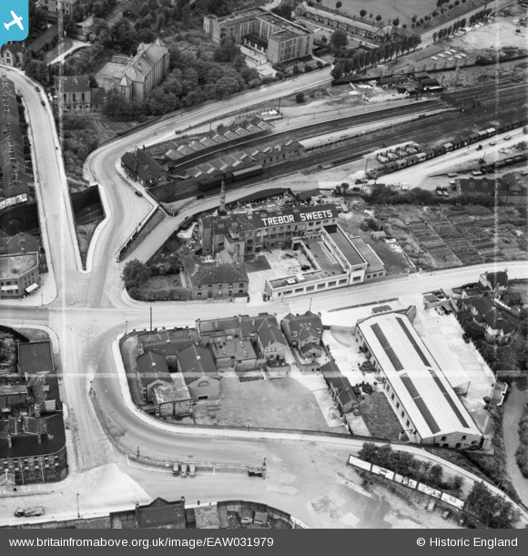
EAW031979 ENGLAND (1950). The Trebor Sweets Factory and Chesterfield Central Railway Station, Chesterfield, 1950. This image was marked by Aerofilms Ltd for photo editing.
© Copyright OpenStreetMap contributors and licensed by the OpenStreetMap Foundation. 2026. Cartography is licensed as CC BY-SA.
Nearby Images (9)
EAW031979

EAW031983

EAW031985

EAW031980

EAW031981

EAW031982

EAW031984

EAW031978

EPW021081

Details
| Title | [EAW031979] The Trebor Sweets Factory and Chesterfield Central Railway Station, Chesterfield, 1950. This image was marked by Aerofilms Ltd for photo editing. |
| Reference | EAW031979 |
| Date | 16-August-1950 |
| Link | |
| Place name | CHESTERFIELD |
| Parish | |
| District | |
| Country | ENGLAND |
| Easting / Northing | 438658, 371453 |
| Longitude / Latitude | -1.4207094389772, 53.238416636821 |
| National Grid Reference | SK387715 |
Pins

RichardL |
Friday 8th of August 2014 08:20:27 AM | |
|
RichardL |
Friday 8th of August 2014 08:19:15 AM | |
|
RichardL |
Friday 8th of August 2014 08:18:32 AM | |
|
RichardL |
Friday 8th of August 2014 08:17:35 AM | |
|
RichardL |
Friday 8th of August 2014 08:15:31 AM | |
|
boltie |
Sunday 6th of July 2014 01:52:02 AM |
User Comment Contributions
Chesterfield Central station was opened in 1892 by the Manchester, Sheffield and Lincolnshire Railway, soon afterwards to become the 'Great Central Railway'. Closed to passengers 1963 and completely in 1967. See http://www.disused-stations.org.uk/c/chesterfield_central/index.shtml for information on its history and photos of the station before and after closure. |
John W |
Tuesday 20th of December 2016 03:09:55 PM |