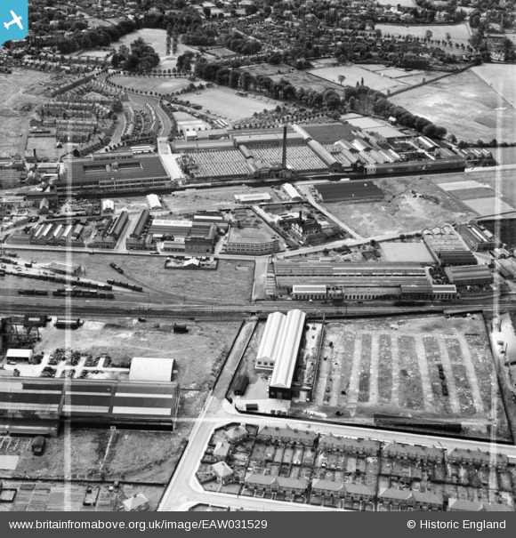
EAW031529 ENGLAND (1950). The H. W. Kearns and Co Ltd Engineering Works and the Linotype Works, Broadheath, 1950. This image was marked by Aerofilms Ltd for photo editing.
© Copyright OpenStreetMap contributors and licensed by the OpenStreetMap Foundation. 2026. Cartography is licensed as CC BY-SA.
Nearby Images (13)
Details
| Title | [EAW031529] The H. W. Kearns and Co Ltd Engineering Works and the Linotype Works, Broadheath, 1950. This image was marked by Aerofilms Ltd for photo editing. |
| Reference | EAW031529 |
| Date | 26-July-1950 |
| Link | |
| Place name | BROADHEATH |
| Parish | |
| District | |
| Country | ENGLAND |
| Easting / Northing | 376183, 389115 |
| Longitude / Latitude | -2.3582312965015, 53.398063484509 |
| National Grid Reference | SJ762891 |
Pins

Matt Aldred edob.mattaldred.com |
Wednesday 17th of August 2022 03:25:33 PM | |

Matt Aldred edob.mattaldred.com |
Wednesday 17th of August 2022 03:14:58 PM | |

AltyCivicSoc |
Monday 13th of July 2020 05:11:12 PM |


![[EAW031529] The H. W. Kearns and Co Ltd Engineering Works and the Linotype Works, Broadheath, 1950. This image was marked by Aerofilms Ltd for photo editing.](http://britainfromabove.org.uk/sites/all/libraries/aerofilms-images/public/100x100/EAW/031/EAW031529.jpg)
![[EAW031527] The H. W. Kearns and Co Ltd Engineering Works and environs, Broadheath, 1950. This image was marked by Aerofilms Ltd for photo editing.](http://britainfromabove.org.uk/sites/all/libraries/aerofilms-images/public/100x100/EAW/031/EAW031527.jpg)
![[EAW031525] The H. W. Kearns and Co Ltd Engineering Works, Broadheath, 1950. This image was marked by Aerofilms Ltd for photo editing.](http://britainfromabove.org.uk/sites/all/libraries/aerofilms-images/public/100x100/EAW/031/EAW031525.jpg)
![[EAW031524] The H. W. Kearns and Co Ltd Engineering Works, Broadheath, 1950](http://britainfromabove.org.uk/sites/all/libraries/aerofilms-images/public/100x100/EAW/031/EAW031524.jpg)
![[EAW031521] The H. W. Kearns and Co Ltd Engineering Works, Broadheath, 1950. This image was marked by Aerofilms Ltd for photo editing.](http://britainfromabove.org.uk/sites/all/libraries/aerofilms-images/public/100x100/EAW/031/EAW031521.jpg)
![[EAW031522] The H. W. Kearns and Co Ltd Engineering Works, Broadheath, 1950. This image was marked by Aerofilms Ltd for photo editing.](http://britainfromabove.org.uk/sites/all/libraries/aerofilms-images/public/100x100/EAW/031/EAW031522.jpg)
![[EAW031526] The H. W. Kearns and Co Ltd Engineering Works and environs, Broadheath, 1950. This image was marked by Aerofilms Ltd for photo editing.](http://britainfromabove.org.uk/sites/all/libraries/aerofilms-images/public/100x100/EAW/031/EAW031526.jpg)
![[EAW031528] The H. W. Kearns and Co Ltd Engineering Works and environs, Broadheath, 1950. This image was marked by Aerofilms Ltd for photo editing.](http://britainfromabove.org.uk/sites/all/libraries/aerofilms-images/public/100x100/EAW/031/EAW031528.jpg)
![[EAW031523] The H. W. Kearns and Co Ltd Engineering Works and environs, Broadheath, 1950](http://britainfromabove.org.uk/sites/all/libraries/aerofilms-images/public/100x100/EAW/031/EAW031523.jpg)
![[EPW050673] The Churchill Machine Tool Works, Broadheath, 1936](http://britainfromabove.org.uk/sites/all/libraries/aerofilms-images/public/100x100/EPW/050/EPW050673.jpg)
![[EPW038468] The Churchill Machine Tool Works, Broadheath, 1932. This image has been produced from a print.](http://britainfromabove.org.uk/sites/all/libraries/aerofilms-images/public/100x100/EPW/038/EPW038468.jpg)
![[EPW038470] The Churchill Machine Tool Works, Broadheath, 1932. This image has been produced from a damaged negative.](http://britainfromabove.org.uk/sites/all/libraries/aerofilms-images/public/100x100/EPW/038/EPW038470.jpg)
![[EPW016489] The Atlantic Engineering Works, Altrincham, 1926](http://britainfromabove.org.uk/sites/all/libraries/aerofilms-images/public/100x100/EPW/016/EPW016489.jpg)
