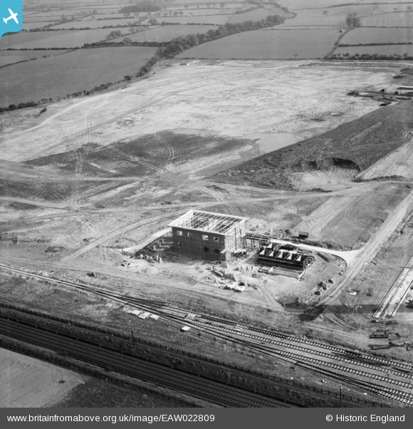
EAW022809 ENGLAND (1949). Part of the Patons and Baldwin's Wool Factory under construction at Lingfield Point, Lingfield, 1949
© Copyright OpenStreetMap contributors and licensed by the OpenStreetMap Foundation. 2026. Cartography is licensed as CC BY-SA.
Nearby Images (26)
Details
| Title | [EAW022809] Part of the Patons and Baldwin's Wool Factory under construction at Lingfield Point, Lingfield, 1949 |
| Reference | EAW022809 |
| Date | 30-April-1949 |
| Link | |
| Place name | LINGFIELD |
| Parish | |
| District | |
| Country | ENGLAND |
| Easting / Northing | 431892, 515200 |
| Longitude / Latitude | -1.507125180218, 54.530944862844 |
| National Grid Reference | NZ319152 |
Pins
Be the first to add a comment to this image!


![[EAW022809] Part of the Patons and Baldwin's Wool Factory under construction at Lingfield Point, Lingfield, 1949](http://britainfromabove.org.uk/sites/all/libraries/aerofilms-images/public/100x100/EAW/022/EAW022809.jpg)
![[EAW022800] Patons and Baldwin's Wool Factory under construction at Lingfield Point, Lingfield, 1949. This image was marked by Aerofilms Ltd for photo editing.](http://britainfromabove.org.uk/sites/all/libraries/aerofilms-images/public/100x100/EAW/022/EAW022800.jpg)
![[EAW022801] Patons and Baldwin's Wool Factory under construction at Lingfield Point, Lingfield, 1949](http://britainfromabove.org.uk/sites/all/libraries/aerofilms-images/public/100x100/EAW/022/EAW022801.jpg)
![[EAW017439] The Patons and Baldwins Worsted Spinning Mill under construction, Darlington, 1948. This image has been produced from a print.](http://britainfromabove.org.uk/sites/all/libraries/aerofilms-images/public/100x100/EAW/017/EAW017439.jpg)
![[EAW013815] Construction of Paton and Baldwins Worsted Spinning Mill at Lingfield Point, Lingfield, 1948. This image was marked by Aerofilms Ltd for photo editing.](http://britainfromabove.org.uk/sites/all/libraries/aerofilms-images/public/100x100/EAW/013/EAW013815.jpg)
![[EAW027449] Part of the Patons and Baldwins Worsted Spinning Mill under construction, Darlington, 1949](http://britainfromabove.org.uk/sites/all/libraries/aerofilms-images/public/100x100/EAW/027/EAW027449.jpg)
![[EAW027456] Part of the Patons and Baldwins Worsted Spinning Mill under construction, Darlington, from the south-east, 1949. This image was marked by Aerofilms Ltd for photo editing.](http://britainfromabove.org.uk/sites/all/libraries/aerofilms-images/public/100x100/EAW/027/EAW027456.jpg)
![[EAW017434] The Patons and Baldwins Worsted Spinning Mill under construction, Darlington, from the north-east, 1948. This image has been produced from a print.](http://britainfromabove.org.uk/sites/all/libraries/aerofilms-images/public/100x100/EAW/017/EAW017434.jpg)
![[EAW034283] The Patons and Baldwins Worsted Spinning Mill, Darlington, 1950. This image has been produced from a print marked by Aerofilms Ltd for photo editing.](http://britainfromabove.org.uk/sites/all/libraries/aerofilms-images/public/100x100/EAW/034/EAW034283.jpg)
![[EAW034275] The Patons and Baldwins Worsted Spinning Mill, Darlington, 1950. This image has been produced from a print marked by Aerofilms Ltd for photo editing.](http://britainfromabove.org.uk/sites/all/libraries/aerofilms-images/public/100x100/EAW/034/EAW034275.jpg)
![[EAW027455] Part of the Patons and Baldwins Worsted Spinning Mill under construction, Darlington, 1949](http://britainfromabove.org.uk/sites/all/libraries/aerofilms-images/public/100x100/EAW/027/EAW027455.jpg)
![[EAW007623] Patons and Baldwins Wool Factory at Lingfield Point under construction, Darlington, from the north-east, 1947](http://britainfromabove.org.uk/sites/all/libraries/aerofilms-images/public/100x100/EAW/007/EAW007623.jpg)
![[EAW027445] The Patons and Baldwins Worsted Spinning Mill, Darlington, 1949](http://britainfromabove.org.uk/sites/all/libraries/aerofilms-images/public/100x100/EAW/027/EAW027445.jpg)
![[EAW027434] The Patons and Baldwins Worsted Spinning Mill, Darlington, 1949. This image was marked by Aerofilms Ltd for photo editing.](http://britainfromabove.org.uk/sites/all/libraries/aerofilms-images/public/100x100/EAW/027/EAW027434.jpg)
![[EAW027435] The Patons and Baldwins Worsted Spinning Mill, Darlington, 1949. This image was marked by Aerofilms Ltd for photo editing.](http://britainfromabove.org.uk/sites/all/libraries/aerofilms-images/public/100x100/EAW/027/EAW027435.jpg)
![[EAW007628] Patons and Baldwins Wool Factory at Lingfield Point under construction, Darlington, 1947](http://britainfromabove.org.uk/sites/all/libraries/aerofilms-images/public/100x100/EAW/007/EAW007628.jpg)
![[EAW007638] Patons and Baldwins Wool Factory at Lingfield Point under construction, Darlington, 1947](http://britainfromabove.org.uk/sites/all/libraries/aerofilms-images/public/100x100/EAW/007/EAW007638.jpg)
![[EAW007639] Patons and Baldwins Wool Factory at Lingfield Point under construction, Darlington, 1947](http://britainfromabove.org.uk/sites/all/libraries/aerofilms-images/public/100x100/EAW/007/EAW007639.jpg)
![[EAW013817] Construction of Paton and Baldwins Worsted Spinning Mill at Lingfield Point, Lingfield, 1948. This image was marked by Aerofilms Ltd for photo editing.](http://britainfromabove.org.uk/sites/all/libraries/aerofilms-images/public/100x100/EAW/013/EAW013817.jpg)
![[EAW022813] Patons and Baldwin's Wool Factory under construction at Lingfield Point, Lingfield, 1949](http://britainfromabove.org.uk/sites/all/libraries/aerofilms-images/public/100x100/EAW/022/EAW022813.jpg)
![[EAW007627] Patons and Baldwins Wool Factory at Lingfield Point under construction, Darlington, 1947](http://britainfromabove.org.uk/sites/all/libraries/aerofilms-images/public/100x100/EAW/007/EAW007627.jpg)
![[EAW022803] Patons and Baldwin's Wool Factory under construction at Lingfield Point, Lingfield, 1949](http://britainfromabove.org.uk/sites/all/libraries/aerofilms-images/public/100x100/EAW/022/EAW022803.jpg)
![[EAW007624] Patons and Baldwins Wool Factory at Lingfield Point under construction, Darlington, 1947](http://britainfromabove.org.uk/sites/all/libraries/aerofilms-images/public/100x100/EAW/007/EAW007624.jpg)
![[EAW007632] Patons and Baldwins Wool Factory at Lingfield Point under construction, Darlington, 1947](http://britainfromabove.org.uk/sites/all/libraries/aerofilms-images/public/100x100/EAW/007/EAW007632.jpg)
![[EAW027454] Part of the Patons and Baldwins Worsted Spinning Mill under construction, Darlington, 1949. This image was marked by Aerofilms Ltd for photo editing.](http://britainfromabove.org.uk/sites/all/libraries/aerofilms-images/public/100x100/EAW/027/EAW027454.jpg)
![[EAW007636] Patons and Baldwins Wool Factory at Lingfield Point under construction, Darlington, 1947](http://britainfromabove.org.uk/sites/all/libraries/aerofilms-images/public/100x100/EAW/007/EAW007636.jpg)