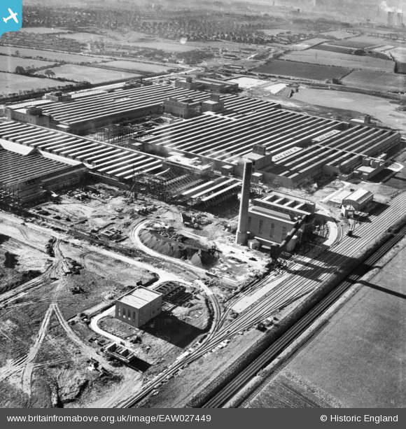
EAW027449 ENGLAND (1949). Part of the Patons and Baldwins Worsted Spinning Mill under construction, Darlington, 1949
© Copyright OpenStreetMap contributors and licensed by the OpenStreetMap Foundation. 2026. Cartography is licensed as CC BY-SA.
Nearby Images (48)
Details
| Title | [EAW027449] Part of the Patons and Baldwins Worsted Spinning Mill under construction, Darlington, 1949 |
| Reference | EAW027449 |
| Date | 27-October-1949 |
| Link | |
| Place name | DARLINGTON |
| Parish | |
| District | |
| Country | ENGLAND |
| Easting / Northing | 431724, 515163 |
| Longitude / Latitude | -1.5097254149048, 54.530622872911 |
| National Grid Reference | NZ317152 |
Pins
Be the first to add a comment to this image!


![[EAW027455] Part of the Patons and Baldwins Worsted Spinning Mill under construction, Darlington, 1949](http://britainfromabove.org.uk/sites/all/libraries/aerofilms-images/public/100x100/EAW/027/EAW027455.jpg)
![[EAW007623] Patons and Baldwins Wool Factory at Lingfield Point under construction, Darlington, from the north-east, 1947](http://britainfromabove.org.uk/sites/all/libraries/aerofilms-images/public/100x100/EAW/007/EAW007623.jpg)
![[EAW007628] Patons and Baldwins Wool Factory at Lingfield Point under construction, Darlington, 1947](http://britainfromabove.org.uk/sites/all/libraries/aerofilms-images/public/100x100/EAW/007/EAW007628.jpg)
![[EAW007638] Patons and Baldwins Wool Factory at Lingfield Point under construction, Darlington, 1947](http://britainfromabove.org.uk/sites/all/libraries/aerofilms-images/public/100x100/EAW/007/EAW007638.jpg)
![[EAW007639] Patons and Baldwins Wool Factory at Lingfield Point under construction, Darlington, 1947](http://britainfromabove.org.uk/sites/all/libraries/aerofilms-images/public/100x100/EAW/007/EAW007639.jpg)
![[EAW013817] Construction of Paton and Baldwins Worsted Spinning Mill at Lingfield Point, Lingfield, 1948. This image was marked by Aerofilms Ltd for photo editing.](http://britainfromabove.org.uk/sites/all/libraries/aerofilms-images/public/100x100/EAW/013/EAW013817.jpg)
![[EAW007633] Patons and Baldwins Wool Factory at Lingfield Point under construction, Darlington, 1947](http://britainfromabove.org.uk/sites/all/libraries/aerofilms-images/public/100x100/EAW/007/EAW007633.jpg)
![[EAW022807] Part of the Patons and Baldwin's Wool Factory under construction at Lingfield Point, Lingfield, from the west, 1949](http://britainfromabove.org.uk/sites/all/libraries/aerofilms-images/public/100x100/EAW/022/EAW022807.jpg)
![[EAW027446] The Patons and Baldwins Worsted Spinning Mill, Darlington, 1949. This image was marked by Aerofilms Ltd for photo editing.](http://britainfromabove.org.uk/sites/all/libraries/aerofilms-images/public/100x100/EAW/027/EAW027446.jpg)
![[EAW022813] Patons and Baldwin's Wool Factory under construction at Lingfield Point, Lingfield, 1949](http://britainfromabove.org.uk/sites/all/libraries/aerofilms-images/public/100x100/EAW/022/EAW022813.jpg)
![[EAW007640] Patons and Baldwins Wool Factory at Lingfield Point under construction, Darlington, 1947](http://britainfromabove.org.uk/sites/all/libraries/aerofilms-images/public/100x100/EAW/007/EAW007640.jpg)
![[EAW017428] The Patons and Baldwins Worsted Spinning Mill under construction, Darlington, 1948. This image has been produced from a print.](http://britainfromabove.org.uk/sites/all/libraries/aerofilms-images/public/100x100/EAW/017/EAW017428.jpg)
![[EAW013820] Construction of Paton and Baldwins Worsted Spinning Mill at Lingfield Point, Lingfield, 1948](http://britainfromabove.org.uk/sites/all/libraries/aerofilms-images/public/100x100/EAW/013/EAW013820.jpg)
![[EAW013824] Construction of Paton and Baldwins Worsted Spinning Mill at Lingfield Point, Lingfield, 1948](http://britainfromabove.org.uk/sites/all/libraries/aerofilms-images/public/100x100/EAW/013/EAW013824.jpg)
![[EAW013823] Construction of Paton and Baldwins Worsted Spinning Mill at Lingfield Point, Lingfield, 1948](http://britainfromabove.org.uk/sites/all/libraries/aerofilms-images/public/100x100/EAW/013/EAW013823.jpg)
![[EAW013816] Construction of Paton and Baldwins Worsted Spinning Mill at Lingfield Point, Lingfield, 1948. This image was marked by Aerofilms Ltd for photo editing.](http://britainfromabove.org.uk/sites/all/libraries/aerofilms-images/public/100x100/EAW/013/EAW013816.jpg)
![[EAW013821] Construction of Paton and Baldwins Worsted Spinning Mill at Lingfield Point, Lingfield, 1948](http://britainfromabove.org.uk/sites/all/libraries/aerofilms-images/public/100x100/EAW/013/EAW013821.jpg)
![[EAW027454] Part of the Patons and Baldwins Worsted Spinning Mill under construction, Darlington, 1949. This image was marked by Aerofilms Ltd for photo editing.](http://britainfromabove.org.uk/sites/all/libraries/aerofilms-images/public/100x100/EAW/027/EAW027454.jpg)
![[EAW013819] Construction of Paton and Baldwins Worsted Spinning Mill at Lingfield Point, Lingfield, 1948](http://britainfromabove.org.uk/sites/all/libraries/aerofilms-images/public/100x100/EAW/013/EAW013819.jpg)
![[EAW007636] Patons and Baldwins Wool Factory at Lingfield Point under construction, Darlington, 1947](http://britainfromabove.org.uk/sites/all/libraries/aerofilms-images/public/100x100/EAW/007/EAW007636.jpg)
![[EAW007632] Patons and Baldwins Wool Factory at Lingfield Point under construction, Darlington, 1947](http://britainfromabove.org.uk/sites/all/libraries/aerofilms-images/public/100x100/EAW/007/EAW007632.jpg)
![[EAW007624] Patons and Baldwins Wool Factory at Lingfield Point under construction, Darlington, 1947](http://britainfromabove.org.uk/sites/all/libraries/aerofilms-images/public/100x100/EAW/007/EAW007624.jpg)
![[EAW027453] The Patons and Baldwins Worsted Spinning Mill, Darlington, 1949. This image was marked by Aerofilms Ltd for photo editing.](http://britainfromabove.org.uk/sites/all/libraries/aerofilms-images/public/100x100/EAW/027/EAW027453.jpg)
![[EAW007635] Patons and Baldwins Wool Factory at Lingfield Point under construction, Darlington, 1947](http://britainfromabove.org.uk/sites/all/libraries/aerofilms-images/public/100x100/EAW/007/EAW007635.jpg)
![[EAW007630] Patons and Baldwins Wool Factory at Lingfield Point under construction, Darlington, 1947](http://britainfromabove.org.uk/sites/all/libraries/aerofilms-images/public/100x100/EAW/007/EAW007630.jpg)
![[EAW013818] Construction of Paton and Baldwins Worsted Spinning Mill at Lingfield Point, Lingfield, 1948](http://britainfromabove.org.uk/sites/all/libraries/aerofilms-images/public/100x100/EAW/013/EAW013818.jpg)
![[EAW027436] The Patons and Baldwins Worsted Spinning Mill, Darlington, 1949. This image was marked by Aerofilms Ltd for photo editing.](http://britainfromabove.org.uk/sites/all/libraries/aerofilms-images/public/100x100/EAW/027/EAW027436.jpg)
![[EAW007637] Patons and Baldwins Wool Factory at Lingfield Point under construction, Darlington, 1947](http://britainfromabove.org.uk/sites/all/libraries/aerofilms-images/public/100x100/EAW/007/EAW007637.jpg)
![[EAW007631] Patons and Baldwins Wool Factory at Lingfield Point under construction, Darlington, 1947](http://britainfromabove.org.uk/sites/all/libraries/aerofilms-images/public/100x100/EAW/007/EAW007631.jpg)
![[EAW007625] Patons and Baldwins Wool Factory at Lingfield Point under construction, Darlington, 1947](http://britainfromabove.org.uk/sites/all/libraries/aerofilms-images/public/100x100/EAW/007/EAW007625.jpg)
![[EAW023498] Patons & Baldwins Worsted Spinning Mill, Darlington, 1949](http://britainfromabove.org.uk/sites/all/libraries/aerofilms-images/public/100x100/EAW/023/EAW023498.jpg)
![[EAW027443] The Patons and Baldwins Worsted Spinning Mill, Darlington, 1949](http://britainfromabove.org.uk/sites/all/libraries/aerofilms-images/public/100x100/EAW/027/EAW027443.jpg)
![[EAW034279] The Patons and Baldwins Worsted Spinning Mill, Darlington, 1950. This image has been produced from a print marked by Aerofilms Ltd for photo editing.](http://britainfromabove.org.uk/sites/all/libraries/aerofilms-images/public/100x100/EAW/034/EAW034279.jpg)
![[EAW023499] Patons & Baldwins Worsted Spinning Mill, Darlington, 1949](http://britainfromabove.org.uk/sites/all/libraries/aerofilms-images/public/100x100/EAW/023/EAW023499.jpg)
![[EAW007626] Patons and Baldwins Wool Factory at Lingfield Point under construction, Darlington, 1947](http://britainfromabove.org.uk/sites/all/libraries/aerofilms-images/public/100x100/EAW/007/EAW007626.jpg)
![[EAW022810] Patons and Baldwin's Wool Factory under construction at Lingfield Point, Lingfield, 1949](http://britainfromabove.org.uk/sites/all/libraries/aerofilms-images/public/100x100/EAW/022/EAW022810.jpg)
![[EAW017429] The Patons and Baldwins Worsted Spinning Mill under construction, Darlington, 1948. This image has been produced from a print.](http://britainfromabove.org.uk/sites/all/libraries/aerofilms-images/public/100x100/EAW/017/EAW017429.jpg)
![[EAW027452] The Patons and Baldwins Worsted Spinning Mill, Darlington, 1949. This image was marked by Aerofilms Ltd for photo editing.](http://britainfromabove.org.uk/sites/all/libraries/aerofilms-images/public/100x100/EAW/027/EAW027452.jpg)
![[EAW023500] Patons & Baldwins Worsted Spinning Mill, Darlington, 1949. This image was marked by Aerofilms Ltd for photo editing.](http://britainfromabove.org.uk/sites/all/libraries/aerofilms-images/public/100x100/EAW/023/EAW023500.jpg)
![[EAW013814] Construction of Paton and Baldwins Worsted Spinning Mill at Lingfield Point, Lingfield, 1948. This image was marked by Aerofilms Ltd for photo editing.](http://britainfromabove.org.uk/sites/all/libraries/aerofilms-images/public/100x100/EAW/013/EAW013814.jpg)
![[EAW034280] The Patons and Baldwins Worsted Spinning Mill, Darlington, 1950. This image has been produced from a print marked by Aerofilms Ltd for photo editing.](http://britainfromabove.org.uk/sites/all/libraries/aerofilms-images/public/100x100/EAW/034/EAW034280.jpg)
![[EAW007629] Patons and Baldwins Wool Factory at Lingfield Point under construction, Darlington, 1947](http://britainfromabove.org.uk/sites/all/libraries/aerofilms-images/public/100x100/EAW/007/EAW007629.jpg)
![[EAW023501] Patons & Baldwins Worsted Spinning Mill, Darlington, 1949](http://britainfromabove.org.uk/sites/all/libraries/aerofilms-images/public/100x100/EAW/023/EAW023501.jpg)
![[EAW023502] Patons & Baldwins Worsted Spinning Mill, Darlington, 1949](http://britainfromabove.org.uk/sites/all/libraries/aerofilms-images/public/100x100/EAW/023/EAW023502.jpg)
![[EAW034272] The Patons and Baldwins Worsted Spinning Mill, Darlington, 1950. This image has been produced from a print marked by Aerofilms Ltd for photo editing.](http://britainfromabove.org.uk/sites/all/libraries/aerofilms-images/public/100x100/EAW/034/EAW034272.jpg)
![[EAW027444] The Patons and Baldwins Worsted Spinning Mill, Darlington, 1949](http://britainfromabove.org.uk/sites/all/libraries/aerofilms-images/public/100x100/EAW/027/EAW027444.jpg)
![[EAW027442] The Patons and Baldwins Worsted Spinning Mill, Darlington, 1949](http://britainfromabove.org.uk/sites/all/libraries/aerofilms-images/public/100x100/EAW/027/EAW027442.jpg)
![[EAW022815] Patons and Baldwin's Wool Factory under construction at Lingfield Point, Lingfield, 1949](http://britainfromabove.org.uk/sites/all/libraries/aerofilms-images/public/100x100/EAW/022/EAW022815.jpg)