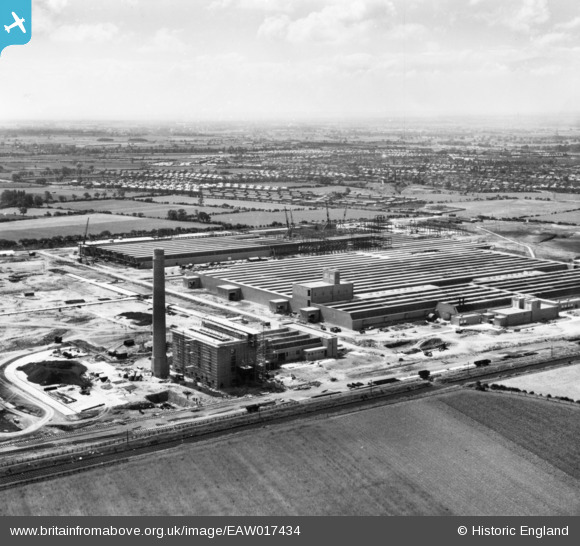
EAW017434 ENGLAND (1948). The Patons and Baldwins Worsted Spinning Mill under construction, Darlington, from the north-east, 1948. This image has been produced from a print.
© Copyright OpenStreetMap contributors and licensed by the OpenStreetMap Foundation. 2026. Cartography is licensed as CC BY-SA.
Nearby Images (36)
Details
| Title | [EAW017434] The Patons and Baldwins Worsted Spinning Mill under construction, Darlington, from the north-east, 1948. This image has been produced from a print. |
| Reference | EAW017434 |
| Date | 24-July-1948 |
| Link | |
| Place name | DARLINGTON |
| Parish | |
| District | |
| Country | ENGLAND |
| Easting / Northing | 431717, 515262 |
| Longitude / Latitude | -1.5098229309717, 54.531513082404 |
| National Grid Reference | NZ317153 |


![[EAW017434] The Patons and Baldwins Worsted Spinning Mill under construction, Darlington, from the north-east, 1948. This image has been produced from a print.](http://britainfromabove.org.uk/sites/all/libraries/aerofilms-images/public/100x100/EAW/017/EAW017434.jpg)
![[EAW017439] The Patons and Baldwins Worsted Spinning Mill under construction, Darlington, 1948. This image has been produced from a print.](http://britainfromabove.org.uk/sites/all/libraries/aerofilms-images/public/100x100/EAW/017/EAW017439.jpg)
![[EAW022807] Part of the Patons and Baldwin's Wool Factory under construction at Lingfield Point, Lingfield, from the west, 1949](http://britainfromabove.org.uk/sites/all/libraries/aerofilms-images/public/100x100/EAW/022/EAW022807.jpg)
![[EAW007623] Patons and Baldwins Wool Factory at Lingfield Point under construction, Darlington, from the north-east, 1947](http://britainfromabove.org.uk/sites/all/libraries/aerofilms-images/public/100x100/EAW/007/EAW007623.jpg)
![[EAW034283] The Patons and Baldwins Worsted Spinning Mill, Darlington, 1950. This image has been produced from a print marked by Aerofilms Ltd for photo editing.](http://britainfromabove.org.uk/sites/all/libraries/aerofilms-images/public/100x100/EAW/034/EAW034283.jpg)
![[EAW027449] Part of the Patons and Baldwins Worsted Spinning Mill under construction, Darlington, 1949](http://britainfromabove.org.uk/sites/all/libraries/aerofilms-images/public/100x100/EAW/027/EAW027449.jpg)
![[EAW007638] Patons and Baldwins Wool Factory at Lingfield Point under construction, Darlington, 1947](http://britainfromabove.org.uk/sites/all/libraries/aerofilms-images/public/100x100/EAW/007/EAW007638.jpg)
![[EAW022801] Patons and Baldwin's Wool Factory under construction at Lingfield Point, Lingfield, 1949](http://britainfromabove.org.uk/sites/all/libraries/aerofilms-images/public/100x100/EAW/022/EAW022801.jpg)
![[EAW027455] Part of the Patons and Baldwins Worsted Spinning Mill under construction, Darlington, 1949](http://britainfromabove.org.uk/sites/all/libraries/aerofilms-images/public/100x100/EAW/027/EAW027455.jpg)
![[EAW013821] Construction of Paton and Baldwins Worsted Spinning Mill at Lingfield Point, Lingfield, 1948](http://britainfromabove.org.uk/sites/all/libraries/aerofilms-images/public/100x100/EAW/013/EAW013821.jpg)
![[EAW007633] Patons and Baldwins Wool Factory at Lingfield Point under construction, Darlington, 1947](http://britainfromabove.org.uk/sites/all/libraries/aerofilms-images/public/100x100/EAW/007/EAW007633.jpg)
![[EAW027446] The Patons and Baldwins Worsted Spinning Mill, Darlington, 1949. This image was marked by Aerofilms Ltd for photo editing.](http://britainfromabove.org.uk/sites/all/libraries/aerofilms-images/public/100x100/EAW/027/EAW027446.jpg)
![[EAW007628] Patons and Baldwins Wool Factory at Lingfield Point under construction, Darlington, 1947](http://britainfromabove.org.uk/sites/all/libraries/aerofilms-images/public/100x100/EAW/007/EAW007628.jpg)
![[EAW013820] Construction of Paton and Baldwins Worsted Spinning Mill at Lingfield Point, Lingfield, 1948](http://britainfromabove.org.uk/sites/all/libraries/aerofilms-images/public/100x100/EAW/013/EAW013820.jpg)
![[EAW007639] Patons and Baldwins Wool Factory at Lingfield Point under construction, Darlington, 1947](http://britainfromabove.org.uk/sites/all/libraries/aerofilms-images/public/100x100/EAW/007/EAW007639.jpg)
![[EAW027445] The Patons and Baldwins Worsted Spinning Mill, Darlington, 1949](http://britainfromabove.org.uk/sites/all/libraries/aerofilms-images/public/100x100/EAW/027/EAW027445.jpg)
![[EAW013816] Construction of Paton and Baldwins Worsted Spinning Mill at Lingfield Point, Lingfield, 1948. This image was marked by Aerofilms Ltd for photo editing.](http://britainfromabove.org.uk/sites/all/libraries/aerofilms-images/public/100x100/EAW/013/EAW013816.jpg)
![[EAW013824] Construction of Paton and Baldwins Worsted Spinning Mill at Lingfield Point, Lingfield, 1948](http://britainfromabove.org.uk/sites/all/libraries/aerofilms-images/public/100x100/EAW/013/EAW013824.jpg)
![[EAW013817] Construction of Paton and Baldwins Worsted Spinning Mill at Lingfield Point, Lingfield, 1948. This image was marked by Aerofilms Ltd for photo editing.](http://britainfromabove.org.uk/sites/all/libraries/aerofilms-images/public/100x100/EAW/013/EAW013817.jpg)
![[EAW022809] Part of the Patons and Baldwin's Wool Factory under construction at Lingfield Point, Lingfield, 1949](http://britainfromabove.org.uk/sites/all/libraries/aerofilms-images/public/100x100/EAW/022/EAW022809.jpg)
![[EAW007640] Patons and Baldwins Wool Factory at Lingfield Point under construction, Darlington, 1947](http://britainfromabove.org.uk/sites/all/libraries/aerofilms-images/public/100x100/EAW/007/EAW007640.jpg)
![[EAW022800] Patons and Baldwin's Wool Factory under construction at Lingfield Point, Lingfield, 1949. This image was marked by Aerofilms Ltd for photo editing.](http://britainfromabove.org.uk/sites/all/libraries/aerofilms-images/public/100x100/EAW/022/EAW022800.jpg)
![[EAW017428] The Patons and Baldwins Worsted Spinning Mill under construction, Darlington, 1948. This image has been produced from a print.](http://britainfromabove.org.uk/sites/all/libraries/aerofilms-images/public/100x100/EAW/017/EAW017428.jpg)
![[EAW027453] The Patons and Baldwins Worsted Spinning Mill, Darlington, 1949. This image was marked by Aerofilms Ltd for photo editing.](http://britainfromabove.org.uk/sites/all/libraries/aerofilms-images/public/100x100/EAW/027/EAW027453.jpg)
![[EAW022813] Patons and Baldwin's Wool Factory under construction at Lingfield Point, Lingfield, 1949](http://britainfromabove.org.uk/sites/all/libraries/aerofilms-images/public/100x100/EAW/022/EAW022813.jpg)
![[EAW013823] Construction of Paton and Baldwins Worsted Spinning Mill at Lingfield Point, Lingfield, 1948](http://britainfromabove.org.uk/sites/all/libraries/aerofilms-images/public/100x100/EAW/013/EAW013823.jpg)
![[EAW007627] Patons and Baldwins Wool Factory at Lingfield Point under construction, Darlington, 1947](http://britainfromabove.org.uk/sites/all/libraries/aerofilms-images/public/100x100/EAW/007/EAW007627.jpg)
![[EAW027443] The Patons and Baldwins Worsted Spinning Mill, Darlington, 1949](http://britainfromabove.org.uk/sites/all/libraries/aerofilms-images/public/100x100/EAW/027/EAW027443.jpg)
![[EAW013819] Construction of Paton and Baldwins Worsted Spinning Mill at Lingfield Point, Lingfield, 1948](http://britainfromabove.org.uk/sites/all/libraries/aerofilms-images/public/100x100/EAW/013/EAW013819.jpg)
![[EAW023499] Patons & Baldwins Worsted Spinning Mill, Darlington, 1949](http://britainfromabove.org.uk/sites/all/libraries/aerofilms-images/public/100x100/EAW/023/EAW023499.jpg)
![[EAW027456] Part of the Patons and Baldwins Worsted Spinning Mill under construction, Darlington, from the south-east, 1949. This image was marked by Aerofilms Ltd for photo editing.](http://britainfromabove.org.uk/sites/all/libraries/aerofilms-images/public/100x100/EAW/027/EAW027456.jpg)
![[EAW023498] Patons & Baldwins Worsted Spinning Mill, Darlington, 1949](http://britainfromabove.org.uk/sites/all/libraries/aerofilms-images/public/100x100/EAW/023/EAW023498.jpg)
![[EAW013814] Construction of Paton and Baldwins Worsted Spinning Mill at Lingfield Point, Lingfield, 1948. This image was marked by Aerofilms Ltd for photo editing.](http://britainfromabove.org.uk/sites/all/libraries/aerofilms-images/public/100x100/EAW/013/EAW013814.jpg)
![[EAW023500] Patons & Baldwins Worsted Spinning Mill, Darlington, 1949. This image was marked by Aerofilms Ltd for photo editing.](http://britainfromabove.org.uk/sites/all/libraries/aerofilms-images/public/100x100/EAW/023/EAW023500.jpg)
![[EAW007629] Patons and Baldwins Wool Factory at Lingfield Point under construction, Darlington, 1947](http://britainfromabove.org.uk/sites/all/libraries/aerofilms-images/public/100x100/EAW/007/EAW007629.jpg)
![[EAW023501] Patons & Baldwins Worsted Spinning Mill, Darlington, 1949](http://britainfromabove.org.uk/sites/all/libraries/aerofilms-images/public/100x100/EAW/023/EAW023501.jpg)
