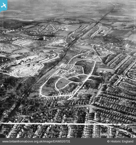
EAW020731 ENGLAND (1948). New housing development around Tillingbourne Green, Poverest, 1948. This image was marked by Aerofilms Ltd for photo editing.
© Copyright OpenStreetMap contributors and licensed by the OpenStreetMap Foundation. 2026. Cartography is licensed as CC BY-SA.
Nearby Images (8)
Details
| Title | [EAW020731] New housing development around Tillingbourne Green, Poverest, 1948. This image was marked by Aerofilms Ltd for photo editing. |
| Reference | EAW020731 |
| Date | 24-December-1948 |
| Link | |
| Place name | POVEREST |
| Parish | |
| District | |
| Country | ENGLAND |
| Easting / Northing | 546134, 168147 |
| Longitude / Latitude | 0.10068241468502, 51.393020962015 |
| National Grid Reference | TQ461681 |
Pins

John |
Thursday 2nd of February 2017 11:02:29 PM | |

John |
Thursday 2nd of February 2017 11:01:01 PM | |

Mike Floate |
Wednesday 31st of December 2014 02:36:02 PM | |

garyb |
Thursday 5th of June 2014 12:35:21 PM | |

garyb |
Thursday 5th of June 2014 12:28:24 PM | |

garyb |
Wednesday 4th of June 2014 10:57:44 PM | |

Tom Burnham |
Friday 23rd of May 2014 11:44:54 PM | |

Tom Burnham |
Friday 23rd of May 2014 11:42:30 PM | |
Closed in the mid to late 1960s when upon Molins moved into the site. Now a retail area. Prior to the mid 1930s the the site was Joynson's Paper Mill having previously been a corn mill. |

garyb |
Thursday 5th of June 2014 11:51:41 AM |

ODAS |
Wednesday 26th of February 2014 08:34:00 PM | |

Gone2Kent |
Thursday 26th of December 2013 09:18:37 PM | |

Mike Floate |
Monday 23rd of December 2013 04:30:55 PM |


![[EAW020731] New housing development around Tillingbourne Green, Poverest, 1948. This image was marked by Aerofilms Ltd for photo editing.](http://britainfromabove.org.uk/sites/all/libraries/aerofilms-images/public/100x100/EAW/020/EAW020731.jpg)
![[EAW020718] Robin Hood Green and new housing development around Tillingbourne Green and Ravensbury Road, Poverest, 1948](http://britainfromabove.org.uk/sites/all/libraries/aerofilms-images/public/100x100/EAW/020/EAW020718.jpg)
![[EAW026808] Housing estate under construction at Poverest, Bromley, 1949. This image was marked by Aerofilms Ltd for photo editing.](http://britainfromabove.org.uk/sites/all/libraries/aerofilms-images/public/100x100/EAW/026/EAW026808.jpg)
![[EAW020732] New housing development around Tillingbourne Green, Poverest, 1948](http://britainfromabove.org.uk/sites/all/libraries/aerofilms-images/public/100x100/EAW/020/EAW020732.jpg)
![[EAW020719] New housing development around Tillingbourne Green and Ravensbury Road, Poverest, 1948](http://britainfromabove.org.uk/sites/all/libraries/aerofilms-images/public/100x100/EAW/020/EAW020719.jpg)
![[EAW020738] Construction of 50 and 52, 75 and 77 Ravensbury Road, St Paul's Cray, 1948](http://britainfromabove.org.uk/sites/all/libraries/aerofilms-images/public/100x100/EAW/020/EAW020738.jpg)
![[EAW020742] Construction of housing around 88 Ravensbury Road, St Paul's Cray, 1948](http://britainfromabove.org.uk/sites/all/libraries/aerofilms-images/public/100x100/EAW/020/EAW020742.jpg)
![[EAW020720] New housing development around Tillingbourne Green and Ravensbury Road, Poverest, 1948](http://britainfromabove.org.uk/sites/all/libraries/aerofilms-images/public/100x100/EAW/020/EAW020720.jpg)

