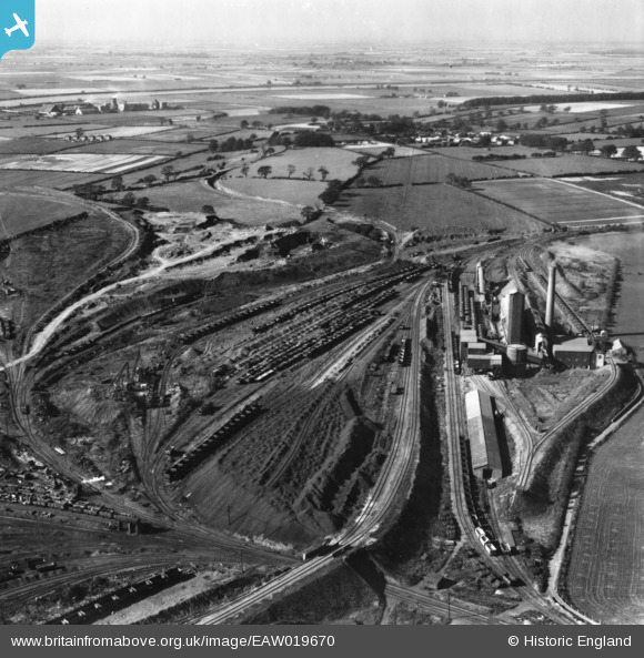
EAW019670 ENGLAND (1948). Part of the John Lysaght Normanby Park Steel Works, Scunthorpe, from the south-east, 1948. This image has been produced from a print.
© Copyright OpenStreetMap contributors and licensed by the OpenStreetMap Foundation. 2026. Cartography is licensed as CC BY-SA.
Nearby Images (41)
Details
| Title | [EAW019670] Part of the John Lysaght Normanby Park Steel Works, Scunthorpe, from the south-east, 1948. This image has been produced from a print. |
| Reference | EAW019670 |
| Date | 5-October-1948 |
| Link | |
| Place name | SCUNTHORPE |
| Parish | |
| District | |
| Country | ENGLAND |
| Easting / Northing | 488524, 414331 |
| Longitude / Latitude | -0.66157350228514, 53.617795223985 |
| National Grid Reference | SE885143 |
Pins
Be the first to add a comment to this image!


![[EAW019670] Part of the John Lysaght Normanby Park Steel Works, Scunthorpe, from the south-east, 1948. This image has been produced from a print.](http://britainfromabove.org.uk/sites/all/libraries/aerofilms-images/public/100x100/EAW/019/EAW019670.jpg)
![[EAW031194] The John Lysaght Normanby Park Steel Works, Scunthorpe, 1950](http://britainfromabove.org.uk/sites/all/libraries/aerofilms-images/public/100x100/EAW/031/EAW031194.jpg)
![[EAW041860] Part of the John Lysaght Normanby Park Steel Works, Scunthorpe, 1952. This image was marked by Aerofilms Ltd for photo editing.](http://britainfromabove.org.uk/sites/all/libraries/aerofilms-images/public/100x100/EAW/041/EAW041860.jpg)
![[EAW041864] Part of the John Lysaght Normanby Park Steel Works, Scunthorpe, 1952. This image was marked by Aerofilms Ltd for photo editing.](http://britainfromabove.org.uk/sites/all/libraries/aerofilms-images/public/100x100/EAW/041/EAW041864.jpg)
![[EAW009634] The John Lysaght Normanby Park Steel Works, Scunthorpe, 1947](http://britainfromabove.org.uk/sites/all/libraries/aerofilms-images/public/100x100/EAW/009/EAW009634.jpg)
![[EAW041827] The John Lysaght Normanby Park Steel Works, Scunthorpe, 1952. This image has been produced from a print.](http://britainfromabove.org.uk/sites/all/libraries/aerofilms-images/public/100x100/EAW/041/EAW041827.jpg)
![[EAW009628] The John Lysaght Normanby Park Steel Works, Scunthorpe, 1947](http://britainfromabove.org.uk/sites/all/libraries/aerofilms-images/public/100x100/EAW/009/EAW009628.jpg)
![[EAW019671] Part of the John Lysaght Normanby Park Steel Works, Scunthorpe, from the south-east, 1948. This image has been produced from a print.](http://britainfromabove.org.uk/sites/all/libraries/aerofilms-images/public/100x100/EAW/019/EAW019671.jpg)
![[EAW019674] Part of the John Lysaght Normanby Park Steel Works and the surrounding area, Scunthorpe, from the south-east, 1948. This image has been produced from a print.](http://britainfromabove.org.uk/sites/all/libraries/aerofilms-images/public/100x100/EAW/019/EAW019674.jpg)
![[EAW023931] The northern end of the John Lysaght Normanby Park Steel Works, Scunthorpe, 1949. This image has been produced from a damaged negative.](http://britainfromabove.org.uk/sites/all/libraries/aerofilms-images/public/100x100/EAW/023/EAW023931.jpg)
![[EAW041862] Part of the John Lysaght Normanby Park Steel Works, Scunthorpe, 1952. This image was marked by Aerofilms Ltd for photo editing.](http://britainfromabove.org.uk/sites/all/libraries/aerofilms-images/public/100x100/EAW/041/EAW041862.jpg)
![[EAW028562] The John Lysaght Normanby Park Steel Works, Scunthorpe, from the north-west, 1950](http://britainfromabove.org.uk/sites/all/libraries/aerofilms-images/public/100x100/EAW/028/EAW028562.jpg)
![[EAW009625] The John Lysaght Normanby Park Steel Works, Scunthorpe, 1947](http://britainfromabove.org.uk/sites/all/libraries/aerofilms-images/public/100x100/EAW/009/EAW009625.jpg)
![[EAW023930] The northern end of the John Lysaght Normanby Park Steel Works, Flixborough, 1949. This image was marked by Aerofilms Ltd for photo editing.](http://britainfromabove.org.uk/sites/all/libraries/aerofilms-images/public/100x100/EAW/023/EAW023930.jpg)
![[EAW016661] John Lysaght Ltd Normanby Park Steel Works, Scunthorpe, 1948](http://britainfromabove.org.uk/sites/all/libraries/aerofilms-images/public/100x100/EAW/016/EAW016661.jpg)
![[EAW049669] The John Lysaght Normanby Park Steel Works, Scunthorpe, 1953. This image was marked by Aerofilms Ltd for photo editing.](http://britainfromabove.org.uk/sites/all/libraries/aerofilms-images/public/100x100/EAW/049/EAW049669.jpg)
![[EPW048530] The John Lysaght Normanby Park Steel Works, Scunthorpe, from the north, 1935](http://britainfromabove.org.uk/sites/all/libraries/aerofilms-images/public/100x100/EPW/048/EPW048530.jpg)
![[EAW021133] Part of the John Lysaght Ltd Normanby Park Steel Works, Flixborough, 1949. This image has been produced from a print.](http://britainfromabove.org.uk/sites/all/libraries/aerofilms-images/public/100x100/EAW/021/EAW021133.jpg)
![[EAW028561] The John Lysaght Normanby Park Steel Works, Scunthorpe, 1950. This image was marked by Aerofilms Ltd for photo editing.](http://britainfromabove.org.uk/sites/all/libraries/aerofilms-images/public/100x100/EAW/028/EAW028561.jpg)
![[EAW028564] Part of the John Lysaght Normanby Park Steel Works, Scunthorpe, 1950](http://britainfromabove.org.uk/sites/all/libraries/aerofilms-images/public/100x100/EAW/028/EAW028564.jpg)
![[EAW021134] Part of the John Lysaght Ltd Normanby Park Steel Works, Flixborough, 1949. This image has been produced from a print.](http://britainfromabove.org.uk/sites/all/libraries/aerofilms-images/public/100x100/EAW/021/EAW021134.jpg)
![[EAW041861] Part of the John Lysaght Normanby Park Steel Works, Scunthorpe, 1952. This image was marked by Aerofilms Ltd for photo editing.](http://britainfromabove.org.uk/sites/all/libraries/aerofilms-images/public/100x100/EAW/041/EAW041861.jpg)
![[EAW028560] Part of the John Lysaght Normanby Park Steel Works, Scunthorpe, 1950. This image was marked by Aerofilms Ltd for photo editing.](http://britainfromabove.org.uk/sites/all/libraries/aerofilms-images/public/100x100/EAW/028/EAW028560.jpg)
![[EAW028563] Part of the John Lysaght Normanby Park Steel Works, Scunthorpe, 1950](http://britainfromabove.org.uk/sites/all/libraries/aerofilms-images/public/100x100/EAW/028/EAW028563.jpg)
![[EAW019672] Part of the John Lysaght Normanby Park Steel Works, Scunthorpe, from the south-west, 1948. This image has been produced from a print.](http://britainfromabove.org.uk/sites/all/libraries/aerofilms-images/public/100x100/EAW/019/EAW019672.jpg)
![[EAW031196] The John Lysaght Normanby Park Steel Works, Scunthorpe, 1950](http://britainfromabove.org.uk/sites/all/libraries/aerofilms-images/public/100x100/EAW/031/EAW031196.jpg)
![[EAW031189] The John Lysaght Normanby Park Steel Works, Scunthorpe, 1950. This image was marked by Aerofilms Ltd for photo editing.](http://britainfromabove.org.uk/sites/all/libraries/aerofilms-images/public/100x100/EAW/031/EAW031189.jpg)
![[EAW041863] Part of the John Lysaght Normanby Park Steel Works, Scunthorpe, 1952. This image was marked by Aerofilms Ltd for photo editing.](http://britainfromabove.org.uk/sites/all/libraries/aerofilms-images/public/100x100/EAW/041/EAW041863.jpg)
![[EAW023929] The northern end of the John Lysaght Normanby Park Steel Works, Flixborough, 1949](http://britainfromabove.org.uk/sites/all/libraries/aerofilms-images/public/100x100/EAW/023/EAW023929.jpg)
![[EAW009624] The John Lysaght Normanby Park Steel Works, Scunthorpe, 1947](http://britainfromabove.org.uk/sites/all/libraries/aerofilms-images/public/100x100/EAW/009/EAW009624.jpg)
![[EAW027187] The northern end of the John Lysaght Normanby Park Steel Works, Scunthorpe, from the west, 1949](http://britainfromabove.org.uk/sites/all/libraries/aerofilms-images/public/100x100/EAW/027/EAW027187.jpg)
![[EAW049674] The John Lysaght Normanby Park Steel Works, Scunthorpe, 1953. This image was marked by Aerofilms Ltd for photo editing.](http://britainfromabove.org.uk/sites/all/libraries/aerofilms-images/public/100x100/EAW/049/EAW049674.jpg)
![[EAW027180] The John Lysaght Normanby Park Steel Works, Scunthorpe, 1949](http://britainfromabove.org.uk/sites/all/libraries/aerofilms-images/public/100x100/EAW/027/EAW027180.jpg)
![[EPW048533] The John Lysaght Normanby Park Steel Works, Scunthorpe, from the north-west, 1935](http://britainfromabove.org.uk/sites/all/libraries/aerofilms-images/public/100x100/EPW/048/EPW048533.jpg)
![[EAW027181] The John Lysaght Normanby Park Steel Works, Scunthorpe, 1949](http://britainfromabove.org.uk/sites/all/libraries/aerofilms-images/public/100x100/EAW/027/EAW027181.jpg)
![[EAW009633] The John Lysaght Normanby Park Steel Works, Scunthorpe, 1947](http://britainfromabove.org.uk/sites/all/libraries/aerofilms-images/public/100x100/EAW/009/EAW009633.jpg)
![[EAW013490] The northern end of the John Lysaght Normanby Park Steel Works site, Scunthorpe, from the south-east, 1948. This image was marked by Aerofilms Ltd for photo editing.](http://britainfromabove.org.uk/sites/all/libraries/aerofilms-images/public/100x100/EAW/013/EAW013490.jpg)
![[EAW034805] Part of the John Lysaght Normanby Park Steel Works, Scunthorpe, 1951. This image has been produced from a print.](http://britainfromabove.org.uk/sites/all/libraries/aerofilms-images/public/100x100/EAW/034/EAW034805.jpg)
![[EAW013489] The northern end of the John Lysaght Normanby Park Steel Works site, Scunthorpe, from the south-west, 1948. This image was marked by Aerofilms Ltd for photo editing.](http://britainfromabove.org.uk/sites/all/libraries/aerofilms-images/public/100x100/EAW/013/EAW013489.jpg)
![[EAW034811] Part of the John Lysaght Normanby Park Steel Works, Scunthorpe, 1951. This image has been produced from a print.](http://britainfromabove.org.uk/sites/all/libraries/aerofilms-images/public/100x100/EAW/034/EAW034811.jpg)
![[EAW016662] John Lysaght Ltd Normanby Park Steel Works and environs, Scunthorpe, 1948](http://britainfromabove.org.uk/sites/all/libraries/aerofilms-images/public/100x100/EAW/016/EAW016662.jpg)