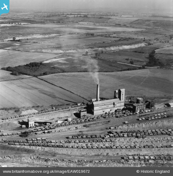
EAW019672 ENGLAND (1948). Part of the John Lysaght Normanby Park Steel Works, Scunthorpe, from the south-west, 1948. This image has been produced from a print.
© Copyright OpenStreetMap contributors and licensed by the OpenStreetMap Foundation. 2025. Cartography is licensed as CC BY-SA.
Nearby Images (28)
Details
| Title | [EAW019672] Part of the John Lysaght Normanby Park Steel Works, Scunthorpe, from the south-west, 1948. This image has been produced from a print. |
| Reference | EAW019672 |
| Date | 5-October-1948 |
| Link | |
| Place name | SCUNTHORPE |
| Parish | |
| District | |
| Country | ENGLAND |
| Easting / Northing | 488350, 414467 |
| Longitude / Latitude | -0.66416489306695, 53.619046818458 |
| National Grid Reference | SE884145 |
Pins
Be the first to add a comment to this image!


![[EAW019672] Part of the John Lysaght Normanby Park Steel Works, Scunthorpe, from the south-west, 1948. This image has been produced from a print.](http://britainfromabove.org.uk/sites/all/libraries/aerofilms-images/public/100x100/EAW/019/EAW019672.jpg)
![[EAW031189] The John Lysaght Normanby Park Steel Works, Scunthorpe, 1950. This image was marked by Aerofilms Ltd for photo editing.](http://britainfromabove.org.uk/sites/all/libraries/aerofilms-images/public/100x100/EAW/031/EAW031189.jpg)
![[EAW009624] The John Lysaght Normanby Park Steel Works, Scunthorpe, 1947](http://britainfromabove.org.uk/sites/all/libraries/aerofilms-images/public/100x100/EAW/009/EAW009624.jpg)
![[EAW041861] Part of the John Lysaght Normanby Park Steel Works, Scunthorpe, 1952. This image was marked by Aerofilms Ltd for photo editing.](http://britainfromabove.org.uk/sites/all/libraries/aerofilms-images/public/100x100/EAW/041/EAW041861.jpg)
![[EAW021133] Part of the John Lysaght Ltd Normanby Park Steel Works, Flixborough, 1949. This image has been produced from a print.](http://britainfromabove.org.uk/sites/all/libraries/aerofilms-images/public/100x100/EAW/021/EAW021133.jpg)
![[EAW021134] Part of the John Lysaght Ltd Normanby Park Steel Works, Flixborough, 1949. This image has been produced from a print.](http://britainfromabove.org.uk/sites/all/libraries/aerofilms-images/public/100x100/EAW/021/EAW021134.jpg)
![[EAW009625] The John Lysaght Normanby Park Steel Works, Scunthorpe, 1947](http://britainfromabove.org.uk/sites/all/libraries/aerofilms-images/public/100x100/EAW/009/EAW009625.jpg)
![[EAW009633] The John Lysaght Normanby Park Steel Works, Scunthorpe, 1947](http://britainfromabove.org.uk/sites/all/libraries/aerofilms-images/public/100x100/EAW/009/EAW009633.jpg)
![[EAW027187] The northern end of the John Lysaght Normanby Park Steel Works, Scunthorpe, from the west, 1949](http://britainfromabove.org.uk/sites/all/libraries/aerofilms-images/public/100x100/EAW/027/EAW027187.jpg)
![[EAW023929] The northern end of the John Lysaght Normanby Park Steel Works, Flixborough, 1949](http://britainfromabove.org.uk/sites/all/libraries/aerofilms-images/public/100x100/EAW/023/EAW023929.jpg)
![[EAW023930] The northern end of the John Lysaght Normanby Park Steel Works, Flixborough, 1949. This image was marked by Aerofilms Ltd for photo editing.](http://britainfromabove.org.uk/sites/all/libraries/aerofilms-images/public/100x100/EAW/023/EAW023930.jpg)
![[EAW028579] The John Lysaght Normanby Park Steel Works, Scunthorpe, from the north-west, 1950](http://britainfromabove.org.uk/sites/all/libraries/aerofilms-images/public/100x100/EAW/028/EAW028579.jpg)
![[EAW019671] Part of the John Lysaght Normanby Park Steel Works, Scunthorpe, from the south-east, 1948. This image has been produced from a print.](http://britainfromabove.org.uk/sites/all/libraries/aerofilms-images/public/100x100/EAW/019/EAW019671.jpg)
![[EAW023931] The northern end of the John Lysaght Normanby Park Steel Works, Scunthorpe, 1949. This image has been produced from a damaged negative.](http://britainfromabove.org.uk/sites/all/libraries/aerofilms-images/public/100x100/EAW/023/EAW023931.jpg)
![[EAW034799] The John Lysaght Normanby Park Steel Works, Scunthorpe, from the north-west, 1951](http://britainfromabove.org.uk/sites/all/libraries/aerofilms-images/public/100x100/EAW/034/EAW034799.jpg)
![[EAW028580] The John Lysaght Normanby Park Steel Works, Scunthorpe, from the north-west, 1950. This image was marked by Aerofilms Ltd for photo editing.](http://britainfromabove.org.uk/sites/all/libraries/aerofilms-images/public/100x100/EAW/028/EAW028580.jpg)
![[EAW021135] Part of the John Lysaght Ltd Normanby Park Steel Works, Flixborough, 1949. This image has been produced from a print.](http://britainfromabove.org.uk/sites/all/libraries/aerofilms-images/public/100x100/EAW/021/EAW021135.jpg)
![[EAW018599G] Part of the John Lysaght Normanby Park Steel Works, Flixborough, 1948. This image has been produced from a damaged negative.](http://britainfromabove.org.uk/sites/all/libraries/aerofilms-images/public/100x100/EAW/018/EAW018599G.jpg)
![[EAW019670] Part of the John Lysaght Normanby Park Steel Works, Scunthorpe, from the south-east, 1948. This image has been produced from a print.](http://britainfromabove.org.uk/sites/all/libraries/aerofilms-images/public/100x100/EAW/019/EAW019670.jpg)
![[EAW031194] The John Lysaght Normanby Park Steel Works, Scunthorpe, 1950](http://britainfromabove.org.uk/sites/all/libraries/aerofilms-images/public/100x100/EAW/031/EAW031194.jpg)
![[EAW041862] Part of the John Lysaght Normanby Park Steel Works, Scunthorpe, 1952. This image was marked by Aerofilms Ltd for photo editing.](http://britainfromabove.org.uk/sites/all/libraries/aerofilms-images/public/100x100/EAW/041/EAW041862.jpg)
![[EAW041864] Part of the John Lysaght Normanby Park Steel Works, Scunthorpe, 1952. This image was marked by Aerofilms Ltd for photo editing.](http://britainfromabove.org.uk/sites/all/libraries/aerofilms-images/public/100x100/EAW/041/EAW041864.jpg)
![[EAW041860] Part of the John Lysaght Normanby Park Steel Works, Scunthorpe, 1952. This image was marked by Aerofilms Ltd for photo editing.](http://britainfromabove.org.uk/sites/all/libraries/aerofilms-images/public/100x100/EAW/041/EAW041860.jpg)
![[EAW009628] The John Lysaght Normanby Park Steel Works, Scunthorpe, 1947](http://britainfromabove.org.uk/sites/all/libraries/aerofilms-images/public/100x100/EAW/009/EAW009628.jpg)
![[EAW009410] The John Lysaght Normanby Park Steel Works, Flixborough, from the north, 1947. This image has been produced from a print.](http://britainfromabove.org.uk/sites/all/libraries/aerofilms-images/public/100x100/EAW/009/EAW009410.jpg)
![[EAW009634] The John Lysaght Normanby Park Steel Works, Scunthorpe, 1947](http://britainfromabove.org.uk/sites/all/libraries/aerofilms-images/public/100x100/EAW/009/EAW009634.jpg)
![[EAW041827] The John Lysaght Normanby Park Steel Works, Scunthorpe, 1952. This image has been produced from a print.](http://britainfromabove.org.uk/sites/all/libraries/aerofilms-images/public/100x100/EAW/041/EAW041827.jpg)
![[EAW019674] Part of the John Lysaght Normanby Park Steel Works and the surrounding area, Scunthorpe, from the south-east, 1948. This image has been produced from a print.](http://britainfromabove.org.uk/sites/all/libraries/aerofilms-images/public/100x100/EAW/019/EAW019674.jpg)