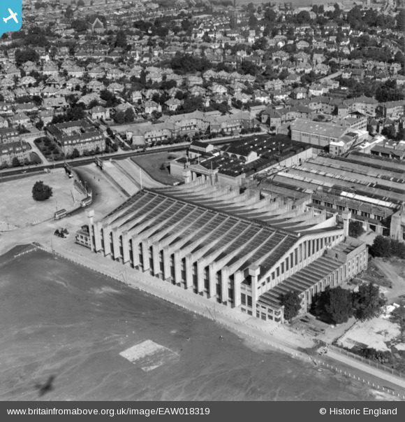
EAW018319 ENGLAND (1948). The Empire Pool, Wembley Park, 1948. This image has been produced from a print.
© Copyright OpenStreetMap contributors and licensed by the OpenStreetMap Foundation. 2026. Cartography is licensed as CC BY-SA.
Nearby Images (48)
Details
| Title | [EAW018319] The Empire Pool, Wembley Park, 1948. This image has been produced from a print. |
| Reference | EAW018319 |
| Date | 24-August-1948 |
| Link | |
| Place name | WEMBLEY PARK |
| Parish | |
| District | |
| Country | ENGLAND |
| Easting / Northing | 519112, 185757 |
| Longitude / Latitude | -0.2816128727739, 51.557626473104 |
| National Grid Reference | TQ191858 |
Pins
Be the first to add a comment to this image!


![[EAW018319] The Empire Pool, Wembley Park, 1948. This image has been produced from a print.](http://britainfromabove.org.uk/sites/all/libraries/aerofilms-images/public/100x100/EAW/018/EAW018319.jpg)
![[EPW045703] The Empire Swimming Pool and Sports Arena, Wembley Park, 1934](http://britainfromabove.org.uk/sites/all/libraries/aerofilms-images/public/100x100/EPW/045/EPW045703.jpg)
![[EPW045946] The Empire Pool and Sports Arena, Wembley Park, 1934](http://britainfromabove.org.uk/sites/all/libraries/aerofilms-images/public/100x100/EPW/045/EPW045946.jpg)
![[EAW018318] The Empire Pool, Wembley Park, 1948. This image has been produced from a print.](http://britainfromabove.org.uk/sites/all/libraries/aerofilms-images/public/100x100/EAW/018/EAW018318.jpg)
![[EPW045944] The Empire Pool and Sports Arena, Wembley Park, 1934](http://britainfromabove.org.uk/sites/all/libraries/aerofilms-images/public/100x100/EPW/045/EPW045944.jpg)
![[EPW045945] The Empire Pool and Sports Arena and the British Empire Stadium, Wembley Park, 1934](http://britainfromabove.org.uk/sites/all/libraries/aerofilms-images/public/100x100/EPW/045/EPW045945.jpg)
![[EPW045943] The Empire Pool and Sports Arena, Wembley Park, 1934](http://britainfromabove.org.uk/sites/all/libraries/aerofilms-images/public/100x100/EPW/045/EPW045943.jpg)
![[EPW046237] The Empire Swimming Pool and Sports Arena and Wembley Stadium, Wembley Park, from the north-west, 1934](http://britainfromabove.org.uk/sites/all/libraries/aerofilms-images/public/100x100/EPW/046/EPW046237.jpg)
![[EPR000224] The Empire Swimming Pool and Sports Arena, Wembley Park, 1934](http://britainfromabove.org.uk/sites/all/libraries/aerofilms-images/public/100x100/EPR/000/EPR000224.jpg)
![[EPW040771] The Palace of Industry alongside Empire Way, Wembley Park, 1932](http://britainfromabove.org.uk/sites/all/libraries/aerofilms-images/public/100x100/EPW/040/EPW040771.jpg)
![[EPW046236] The Empire Swimming Pool and Sports Arena and Wembley Stadium, Wembley Park, from the north-west, 1934](http://britainfromabove.org.uk/sites/all/libraries/aerofilms-images/public/100x100/EPW/046/EPW046236.jpg)
![[EPW045706] The Empire Swimming Pool and Sports Arena, Wembley Stadium and environs, Wembley Park, 1934. This image has been produced from a damaged negative.](http://britainfromabove.org.uk/sites/all/libraries/aerofilms-images/public/100x100/EPW/045/EPW045706.jpg)
![[EPW046239] The Empire Swimming Pool and Sports Arena and Wembley Stadium, Wembley Park, 1934](http://britainfromabove.org.uk/sites/all/libraries/aerofilms-images/public/100x100/EPW/046/EPW046239.jpg)
![[EPW045705] The Empire Swimming Pool and Sports Arena and the Palace of Arts, Wembley Park, 1934](http://britainfromabove.org.uk/sites/all/libraries/aerofilms-images/public/100x100/EPW/045/EPW045705.jpg)
![[EAW018317] The Empire Pool, Wembley Park, 1948. This image has been produced from a print.](http://britainfromabove.org.uk/sites/all/libraries/aerofilms-images/public/100x100/EAW/018/EAW018317.jpg)
![[EPR000222] The Empire Swimming Pool and Sports Arena, Wembley Park, 1934](http://britainfromabove.org.uk/sites/all/libraries/aerofilms-images/public/100x100/EPR/000/EPR000222.jpg)
![[EPW046238] The Empire Swimming Pool and Sports Arena and Wembley Stadium, Wembley Park, from the north-west, 1934](http://britainfromabove.org.uk/sites/all/libraries/aerofilms-images/public/100x100/EPW/046/EPW046238.jpg)
![[EPW046235] The Empire Swimming Pool and Sports Arena and Wembley Stadium, Wembley Park, from the north-west, 1934](http://britainfromabove.org.uk/sites/all/libraries/aerofilms-images/public/100x100/EPW/046/EPW046235.jpg)
![[EPR000223] The Empire Swimming Pool and Sports Arena, Wembley Park, 1934](http://britainfromabove.org.uk/sites/all/libraries/aerofilms-images/public/100x100/EPR/000/EPR000223.jpg)
![[EPW009547] The Palace of Industries and pavilions of the British Empire Exhibition under construction, Wembley Park, 1923](http://britainfromabove.org.uk/sites/all/libraries/aerofilms-images/public/100x100/EPW/009/EPW009547.jpg)
![[EPW009602] The British Empire Exhibition site, Wembley Park, 1923](http://britainfromabove.org.uk/sites/all/libraries/aerofilms-images/public/100x100/EPW/009/EPW009602.jpg)
![[EPW009545] The Palaces of Industries and Arts and the Conference Halls of the British Empire Exhibition under construction, Wembley Park, 1923](http://britainfromabove.org.uk/sites/all/libraries/aerofilms-images/public/100x100/EPW/009/EPW009545.jpg)
![[EPW035047] Wembley Park, Wembley Park before the start of the Cup Final between West Bromwich Albion and Birmingham, 1931](http://britainfromabove.org.uk/sites/all/libraries/aerofilms-images/public/100x100/EPW/035/EPW035047.jpg)
![[EPW017624] Wembley Park and Stadium, Wembley, 1927](http://britainfromabove.org.uk/sites/all/libraries/aerofilms-images/public/100x100/EPW/017/EPW017624.jpg)
![[EPW006967] Wembley Park and Wembley Hill Railway Station, Wembley Park, 1921. This image has been produced from a copy-negative.](http://britainfromabove.org.uk/sites/all/libraries/aerofilms-images/public/100x100/EPW/006/EPW006967.jpg)
![[EPW046906] Wembley Park, car parking at the FA Cup Final between Sheffield Wednesday and West Bromwich Albion, from the north-west, 1935](http://britainfromabove.org.uk/sites/all/libraries/aerofilms-images/public/100x100/EPW/046/EPW046906.jpg)
![[EPW017625] Wembley Park and Stadium, Wembley, 1927](http://britainfromabove.org.uk/sites/all/libraries/aerofilms-images/public/100x100/EPW/017/EPW017625.jpg)
![[EPW017623] Wembley Park and Stadium, Wembley, 1927](http://britainfromabove.org.uk/sites/all/libraries/aerofilms-images/public/100x100/EPW/017/EPW017623.jpg)
![[EPW012752] The British Empire Exhibition, Wembley Park, 1925](http://britainfromabove.org.uk/sites/all/libraries/aerofilms-images/public/100x100/EPW/012/EPW012752.jpg)
![[EAW017619] Wembley Park, crowds gathering at the Empire Stadium for the opening ceremony of the 1948 London Olympics, 1948. This image has been produced from a print.](http://britainfromabove.org.uk/sites/all/libraries/aerofilms-images/public/100x100/EAW/017/EAW017619.jpg)
![[EAW017620] Wembley Park, the Empire Stadium car park on the day of the opening ceremony of the 1948 London Olympics, 1948. This image has been produced from a print.](http://britainfromabove.org.uk/sites/all/libraries/aerofilms-images/public/100x100/EAW/017/EAW017620.jpg)
![[EPW035045] Manor Drive, traffic queueing on Empire Way and the Palace of Industry, Wembley Park, 1931. This image has been produced from a damaged negative.](http://britainfromabove.org.uk/sites/all/libraries/aerofilms-images/public/100x100/EPW/035/EPW035045.jpg)
![[EPW009806] The British Empire Exhibition, Wembley Park, 1924](http://britainfromabove.org.uk/sites/all/libraries/aerofilms-images/public/100x100/EPW/009/EPW009806.jpg)
![[EPW046914] Wembley Park, car parking at the FA Cup Final between Sheffield Wednesday and West Bromwich Albion, from the west, 1935](http://britainfromabove.org.uk/sites/all/libraries/aerofilms-images/public/100x100/EPW/046/EPW046914.jpg)
![[EAW018316] Part of the Empire Stadium, Olympic Way and environs, Wembley Park, 1948. This image has been produced from a print.](http://britainfromabove.org.uk/sites/all/libraries/aerofilms-images/public/100x100/EAW/018/EAW018316.jpg)
![[EPW035048] Wembley Park, Wembley Park before the start of the Cup Final between West Bromwich Albion and Birmingham, 1931. This image has been produced from a damaged negative.](http://britainfromabove.org.uk/sites/all/libraries/aerofilms-images/public/100x100/EPW/035/EPW035048.jpg)
![[EAW017618] Wembley Park, crowds gathering at the Empire Stadium for the opening ceremony of the 1948 London Olympics, 1948. This image has been produced from a print.](http://britainfromabove.org.uk/sites/all/libraries/aerofilms-images/public/100x100/EAW/017/EAW017618.jpg)
![[EPW017632] Wembley Park, car parking at the FA Cup Final between Cardiff City and Arsenal, 1927](http://britainfromabove.org.uk/sites/all/libraries/aerofilms-images/public/100x100/EPW/017/EPW017632.jpg)
![[EPW009807] The Palace of Industries and Palace of Engineering at the British Empire Exhibition, Wembley Park, 1924](http://britainfromabove.org.uk/sites/all/libraries/aerofilms-images/public/100x100/EPW/009/EPW009807.jpg)
![[EPW008242] The Palace of Industry and Palace of Engineering under construction, Wembley Park, 1923. This image has been produced from a copy-negative.](http://britainfromabove.org.uk/sites/all/libraries/aerofilms-images/public/100x100/EPW/008/EPW008242.jpg)
![[EAW038566] Wembley Park, the Speedway semi-final of the London Cup (Wembley vs New Cross) at Wembley Stadium, 1951. This image has been produced from a print.](http://britainfromabove.org.uk/sites/all/libraries/aerofilms-images/public/100x100/EAW/038/EAW038566.jpg)
![[EPW008076] The British Empire Exhibition Stadium (Wembley Stadium) under construction, Wembley Park, from the north-west, 1922. This image has been produced from a copy-negative.](http://britainfromabove.org.uk/sites/all/libraries/aerofilms-images/public/100x100/EPW/008/EPW008076.jpg)
![[EPW046907] Wembley Park, the FA Cup Final between Sheffield Wednesday and West Bromwich Albion, 1935](http://britainfromabove.org.uk/sites/all/libraries/aerofilms-images/public/100x100/EPW/046/EPW046907.jpg)
![[EPW017635] Wembley Park, The FA Cup Final between Cardiff City and Arsenal, 1927](http://britainfromabove.org.uk/sites/all/libraries/aerofilms-images/public/100x100/EPW/017/EPW017635.jpg)
![[EAW048875] Wembley Stadium and the Palace of Industry, Wembley Park, 1953](http://britainfromabove.org.uk/sites/all/libraries/aerofilms-images/public/100x100/EAW/048/EAW048875.jpg)
![[EPW046905] Wembley Park, the FA Cup Final between Sheffield Wednesday and West Bromwich Albion, 1935](http://britainfromabove.org.uk/sites/all/libraries/aerofilms-images/public/100x100/EPW/046/EPW046905.jpg)
![[EAW048879] Wembley Stadium and the Palace of Industry, Wembley Park, 1953](http://britainfromabove.org.uk/sites/all/libraries/aerofilms-images/public/100x100/EAW/048/EAW048879.jpg)
![[EPW020865] Wembley Park, The FA Cup Final between Blackburn Rovers and Huddersfield Town, 1928](http://britainfromabove.org.uk/sites/all/libraries/aerofilms-images/public/100x100/EPW/020/EPW020865.jpg)