
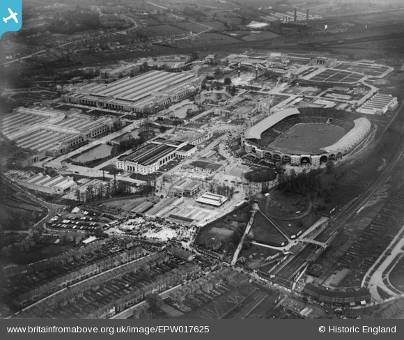
EPW017625 ENGLAND (1927). Wembley Park and Stadium, Wembley, 1927
© Copyright OpenStreetMap contributors and licensed by the OpenStreetMap Foundation. 2026. Cartography is licensed as CC BY-SA.
Nearby Images (48)
EPW017625

EPW017624

EPW046906

EPW046914

EAW017619

EAW017620

EPW017623

EPW035048

EPW006967

EAW017618

EPW035047

EPW046239

EPW046910

EPW046238

EAW038566
 at Wembley Stadium, 1951. This image has been produced from a print.")
EPR000222

EAW038567
 at Wembley Stadium, 1951. This image has been produced from a print.")
EPR000223

EPW045943

EPW045706

EPW009602

EPW045944

EAW018313

EPR000224

EPW046907

EPW017632

EPW010459

EPW045703

EPW026431

EAW018319

EPW034581

EPW045946

EPW040771

EPW046237

EAW018318

EAW018311

EPW010461

EPW010460

EAW018312

EPW045945

EPW010457

EPW009652

EPW046236

EAW018317

EPW045705

EPW020870

EPW046235

EAW041245

Details
| Title | [EPW017625] Wembley Park and Stadium, Wembley, 1927 |
| Reference | EPW017625 |
| Date | 23-April-1927 |
| Link | |
| Place name | WEMBLEY |
| Parish | |
| District | |
| Country | ENGLAND |
| Easting / Northing | 519155, 185592 |
| Longitude / Latitude | -0.28104875117157, 51.556134308848 |
| National Grid Reference | TQ192856 |
Pins

The Laird |
Saturday 18th of February 2023 02:56:30 PM | |
|
The Laird |
Saturday 18th of February 2023 02:53:39 PM | |
|
The Laird |
Saturday 18th of February 2023 02:51:33 PM | |
|
The Laird |
Friday 21st of October 2022 07:45:25 PM | |
|
The Laird |
Friday 21st of October 2022 07:34:03 PM | |
|
The Laird |
Friday 21st of October 2022 07:31:44 PM | |
|
The Laird |
Friday 21st of October 2022 07:29:41 PM | |
|
The Laird |
Friday 21st of October 2022 07:22:13 PM | |
|
The Laird |
Friday 21st of October 2022 02:58:46 PM | |
|
The Laird |
Friday 21st of October 2022 02:56:29 PM | |
 |
PhilWHS |
Sunday 8th of June 2014 07:38:39 PM |
 |
PhilWHS |
Monday 26th of August 2013 02:42:19 PM |

Maurice |
Thursday 17th of January 2013 09:14:33 PM | |
I think you may mean turning loop for Road-rail line. It is likely that this closed at the end of 1924 |
Martin |
Thursday 4th of July 2013 07:15:34 PM |
|
Maurice |
Thursday 17th of January 2013 09:11:45 PM | |
|
Maurice |
Thursday 17th of January 2013 09:07:23 PM | |
|
Maurice |
Thursday 17th of January 2013 09:06:29 PM |
User Comment Contributions

Wembley Stadium was built in 1922/23 as a multipurpose athletics and entertainment centre for the British Empire Exhibition of 1924/25, seen on the left-hand side (northern)of the photograph. Most of the exhibition buildings were designed by Sir John Simpson and Maxwell Ayrton and constructed in ferro-concrete, at a cost in excess of £10 million. A rare image of one of the main venues for significant events of the "Roaring Twenties". Upwards of 25 million visitors attended the exhibition during the summer of 1924. |

John Swain |
Tuesday 4th of June 2013 06:27:33 AM |
John - Thanks for the comment on EPW005603 and the growth of London. The Wembley pictures, of which this is just one, attract me as my father worked on the site for the surveying firm Baker and Mallet before starting his career in the Southern and British Railways. I have made some annotations on other Wembley pictures relating to the Never Stop Railway which ran around the eastern and north sides of the site and which was of great fascination to my father. As may be seen from many of my 'picture pins' it was railways that brought me to geography and geography that brought me to teaching in London and Devon. Like you, I am now retired. |
Maurice |
Tuesday 4th of June 2013 06:27:33 AM |