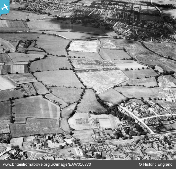
EAW016773 ENGLAND (1948). Fields between Northern Moor and the River Mersey, Northenden, 1948
© Copyright OpenStreetMap contributors and licensed by the OpenStreetMap Foundation. 2026. Cartography is licensed as CC BY-SA.
Nearby Images (16)
Details
| Title | [EAW016773] Fields between Northern Moor and the River Mersey, Northenden, 1948 |
| Reference | EAW016773 |
| Date | 23-June-1948 |
| Link | |
| Place name | NORTHENDEN |
| Parish | |
| District | |
| Country | ENGLAND |
| Easting / Northing | 381830, 391061 |
| Longitude / Latitude | -2.2734081825882, 53.415781646922 |
| National Grid Reference | SJ818911 |
Pins

brian chadwick |
Monday 9th of June 2014 02:45:25 PM | |

John Ellis |
Wednesday 25th of December 2013 10:31:20 AM | |

John Ellis |
Wednesday 25th of December 2013 10:30:29 AM | |

John Ellis |
Wednesday 25th of December 2013 10:29:46 AM | |

John Ellis |
Wednesday 25th of December 2013 10:28:24 AM | |

John Ellis |
Wednesday 25th of December 2013 10:26:28 AM | |

John Ellis |
Wednesday 25th of December 2013 10:25:13 AM | |

John Ellis |
Wednesday 25th of December 2013 10:23:27 AM | |

John Ellis |
Wednesday 25th of December 2013 10:20:07 AM | |

John Ellis |
Wednesday 25th of December 2013 10:18:00 AM | |

John Ellis |
Wednesday 25th of December 2013 10:16:48 AM | |

John Ellis |
Wednesday 25th of December 2013 10:13:18 AM | |

John Ellis |
Wednesday 25th of December 2013 10:12:30 AM | |

John Ellis |
Wednesday 25th of December 2013 10:11:51 AM | |

John Ellis |
Wednesday 25th of December 2013 10:10:00 AM | |

John Ellis |
Wednesday 25th of December 2013 10:07:12 AM | |

John Ellis |
Wednesday 25th of December 2013 10:06:06 AM | |

John Ellis |
Wednesday 25th of December 2013 10:04:42 AM | |

John Ellis |
Wednesday 25th of December 2013 10:01:32 AM | |

John Ellis |
Wednesday 25th of December 2013 10:00:05 AM | |

John Ellis |
Wednesday 25th of December 2013 09:59:18 AM | |

John Ellis |
Wednesday 25th of December 2013 09:58:34 AM | |

John Ellis |
Wednesday 25th of December 2013 09:57:38 AM | |

John Ellis |
Wednesday 25th of December 2013 09:56:41 AM | |

John Ellis |
Wednesday 25th of December 2013 09:54:42 AM | |

John Ellis |
Wednesday 25th of December 2013 09:53:00 AM | |

John Ellis |
Wednesday 25th of December 2013 09:50:49 AM | |

John Ellis |
Wednesday 25th of December 2013 09:49:21 AM | |

John Ellis |
Wednesday 25th of December 2013 09:47:59 AM | |
this is not the Yew Tree. the Yew Tree is next door (to the Right).these cottages still exist. |

brian chadwick |
Tuesday 18th of March 2014 05:01:53 PM |

John Ellis |
Wednesday 25th of December 2013 09:45:56 AM | |

John Ellis |
Wednesday 25th of December 2013 09:45:15 AM |


![[EAW016773] Fields between Northern Moor and the River Mersey, Northenden, 1948](http://britainfromabove.org.uk/sites/all/libraries/aerofilms-images/public/100x100/EAW/016/EAW016773.jpg)
![[EAW016769] Fields between Northern Moor and the River Mersey, Northenden, 1948](http://britainfromabove.org.uk/sites/all/libraries/aerofilms-images/public/100x100/EAW/016/EAW016769.jpg)
![[EAW016768] Fields between Northern Moor and the River Mersey, Northenden, 1948](http://britainfromabove.org.uk/sites/all/libraries/aerofilms-images/public/100x100/EAW/016/EAW016768.jpg)
![[EAW016495] The site for the University of Manchester Sports Ground, Northenden, 1948. This image has been produced from a print.](http://britainfromabove.org.uk/sites/all/libraries/aerofilms-images/public/100x100/EAW/016/EAW016495.jpg)
![[EAW016494] The site for the University of Manchester Sports Ground, Northenden, 1948. This image has been produced from a print.](http://britainfromabove.org.uk/sites/all/libraries/aerofilms-images/public/100x100/EAW/016/EAW016494.jpg)
![[EAW016492] The site for the University of Manchester Sports Ground, Northenden, 1948. This image has been produced from a print marked by Aerofilms Ltd for photo editing.](http://britainfromabove.org.uk/sites/all/libraries/aerofilms-images/public/100x100/EAW/016/EAW016492.jpg)
![[EAW016766] Fields between Northern Moor and the River Mersey, Northenden, 1948](http://britainfromabove.org.uk/sites/all/libraries/aerofilms-images/public/100x100/EAW/016/EAW016766.jpg)
![[EAW016771] Fields between Northern Moor and the River Mersey, Northenden, 1948](http://britainfromabove.org.uk/sites/all/libraries/aerofilms-images/public/100x100/EAW/016/EAW016771.jpg)
![[EAW016774] Fields between Northern Moor and the River Mersey, Northenden, 1948](http://britainfromabove.org.uk/sites/all/libraries/aerofilms-images/public/100x100/EAW/016/EAW016774.jpg)
![[EAW016493] The site for the University of Manchester Sports Ground, Northenden, 1948. This image has been produced from a print marked by Aerofilms Ltd for photo editing.](http://britainfromabove.org.uk/sites/all/libraries/aerofilms-images/public/100x100/EAW/016/EAW016493.jpg)
![[EAW016491] The site for the University of Manchester Sports Ground and Barlow Moor, Northenden, 1948. This image has been produced from a print marked by Aerofilms Ltd for photo editing.](http://britainfromabove.org.uk/sites/all/libraries/aerofilms-images/public/100x100/EAW/016/EAW016491.jpg)
![[EAW016767] Fields between Northern Moor and the River Mersey, Northenden, 1948](http://britainfromabove.org.uk/sites/all/libraries/aerofilms-images/public/100x100/EAW/016/EAW016767.jpg)
![[EPW017443] Fields around Waterside Farm and the Sale and Chorlton-cum-Hardy Golf Courses, Northenden, 1927](http://britainfromabove.org.uk/sites/all/libraries/aerofilms-images/public/100x100/EPW/017/EPW017443.jpg)
![[EAW016770] Fields between Northern Moor and the River Mersey, Northenden, 1948](http://britainfromabove.org.uk/sites/all/libraries/aerofilms-images/public/100x100/EAW/016/EAW016770.jpg)
![[EAW016772] Fields between Northern Moor and the River Mersey, Northenden, 1948](http://britainfromabove.org.uk/sites/all/libraries/aerofilms-images/public/100x100/EAW/016/EAW016772.jpg)
![[EAW016775] Fields to the north of Northern Moor near the River Mersey, Northenden, 1948](http://britainfromabove.org.uk/sites/all/libraries/aerofilms-images/public/100x100/EAW/016/EAW016775.jpg)