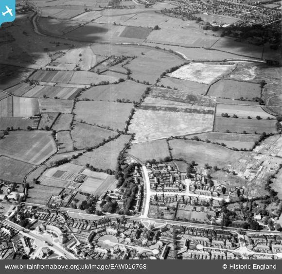
EAW016768 ENGLAND (1948). Fields between Northern Moor and the River Mersey, Northenden, 1948
    © Copyright OpenStreetMap contributors and licensed by the OpenStreetMap Foundation. 2025. Cartography is licensed as CC BY-SA.
  
Nearby Images (12)
Details
| Title | [EAW016768] Fields between Northern Moor and the River Mersey, Northenden, 1948 | 
| Reference | EAW016768 | 
| Date | 23-July-1948 | 
| Link | |
| Place name | NORTHENDEN | 
| Parish | |
| District | |
| Country | ENGLAND | 
| Easting / Northing | 381839, 390995 | 
| Longitude / Latitude | -2.2732689558191, 53.415188650727 | 
| National Grid Reference | SJ818910 | 
Pins
|  24 raymond rd my grandfather/mother (jones) lived here |   brian chadwick | Monday 9th of June 2014 02:36:24 PM | 
|  Peplar avenue |   brian chadwick | Monday 9th of June 2014 02:32:18 PM | 
|  this area became part of the "Mersey tip" |   brian chadwick | Tuesday 18th of March 2014 04:49:01 PM | 
|  Beech House ? building still exists as a nursing home. |   brian chadwick | Tuesday 18th of March 2014 04:22:07 PM | 
|  In the 60's these outbuildings were used as lock up garages |   brian chadwick | Tuesday 18th of March 2014 04:17:29 PM | 
|  Yew Tree Farm |   brian chadwick | Tuesday 18th of March 2014 04:14:48 PM | 
|  Yew Tree House |   brian chadwick | Tuesday 18th of March 2014 04:12:32 PM | 
|  YEW TREE HOTEL |   brian chadwick | Tuesday 18th of March 2014 04:00:28 PM | 
|  Westernmost end of Kenworthy Lane |   John Ellis | Wednesday 25th of December 2013 09:43:52 AM | 
|  Carloon House |   John Ellis | Wednesday 25th of December 2013 09:42:53 AM | 
|  Fairy Lane, towards Sale Moor |   John Ellis | Wednesday 25th of December 2013 09:42:00 AM | 
|  Waterside Farm (now demolished; site beneath an electricity substation) |   John Ellis | Wednesday 25th of December 2013 09:39:28 AM | 
|  Rifle Road, towards Sale Moor |   John Ellis | Wednesday 25th of December 2013 12:51:15 AM | 
|  Bridge Inn and "Jackson's Boat" - once a ferry and now the bridge over the Mersey linking Sale Moor with Chorlton via Rifle Road and Sale Old Hall. |   John Ellis | Wednesday 25th of December 2013 12:50:20 AM | 
|  Hardy Farm (now demolished) |   John Ellis | Wednesday 25th of December 2013 12:47:25 AM | 
|  Hardy Lane |   John Ellis | Wednesday 25th of December 2013 12:46:32 AM | 
|  Barlow Hall Farm (now demolished) |   John Ellis | Wednesday 25th of December 2013 12:45:54 AM | 
|  Barlow Hall (historic house, former home of the family of the Elizabethan Roman Catholic priest/martyr Ambrose Barlow - now a golf club house) |   John Ellis | Wednesday 25th of December 2013 12:45:07 AM | 
|  Darley Avenue |   John Ellis | Wednesday 25th of December 2013 12:42:14 AM | 
|  Barlow Hall Road |   John Ellis | Wednesday 25th of December 2013 12:40:20 AM | 
|  Barlow Moor Road (now A5145) |   John Ellis | Wednesday 25th of December 2013 12:39:41 AM | 
|  Manchester Crematorium, Chorlton-cum-Hardy. |   John Ellis | Wednesday 25th of December 2013 12:37:15 AM | 
|  River Mersey - historic boundary between Cheshire and Lancashire. |   John Ellis | Wednesday 25th of December 2013 12:35:58 AM | 
|  Pingot Drive |   John Ellis | Wednesday 25th of December 2013 12:34:54 AM | 
| pingot avenue |   brian chadwick | Tuesday 18th of March 2014 03:51:08 PM | 
|  Rack House Road |   John Ellis | Wednesday 25th of December 2013 12:34:31 AM | 
|  Hollyhey Drive |   John Ellis | Wednesday 25th of December 2013 12:33:48 AM | 
|  Barry Road |   John Ellis | Wednesday 25th of December 2013 12:32:35 AM | 
|  Raymond Road |   John Ellis | Wednesday 25th of December 2013 12:32:13 AM | 
|  Oak Farm |   John Ellis | Wednesday 25th of December 2013 12:29:01 AM | 
|  Woodville - now a community centre and scene of Duchess Sarah Ferguson's awkward televised encounter with local folk. |   John Ellis | Wednesday 25th of December 2013 12:27:20 AM | 
|  Sale Road Circle - local shopping centre |   John Ellis | Wednesday 25th of December 2013 12:25:00 AM | 
|  Sale Road (B5166) |   John Ellis | Wednesday 25th of December 2013 12:24:07 AM | 
|  Yew Tree Lane |   John Ellis | Wednesday 25th of December 2013 12:23:03 AM | 
 
             
  ![[EAW016768] Fields between Northern Moor and the River Mersey, Northenden, 1948](http://britainfromabove.org.uk/sites/all/libraries/aerofilms-images/public/100x100/EAW/016/EAW016768.jpg) 
  
                                          ![[EAW016773] Fields between Northern Moor and the River Mersey, Northenden, 1948](http://britainfromabove.org.uk/sites/all/libraries/aerofilms-images/public/100x100/EAW/016/EAW016773.jpg) 
 ![[EAW016774] Fields between Northern Moor and the River Mersey, Northenden, 1948](http://britainfromabove.org.uk/sites/all/libraries/aerofilms-images/public/100x100/EAW/016/EAW016774.jpg) 
 ![[EAW016494] The site for the University of Manchester Sports Ground, Northenden, 1948. This image has been produced from a print.](http://britainfromabove.org.uk/sites/all/libraries/aerofilms-images/public/100x100/EAW/016/EAW016494.jpg) 
 ![[EAW016769] Fields between Northern Moor and the River Mersey, Northenden, 1948](http://britainfromabove.org.uk/sites/all/libraries/aerofilms-images/public/100x100/EAW/016/EAW016769.jpg) 
 ![[EAW016495] The site for the University of Manchester Sports Ground, Northenden, 1948. This image has been produced from a print.](http://britainfromabove.org.uk/sites/all/libraries/aerofilms-images/public/100x100/EAW/016/EAW016495.jpg) 
 ![[EAW016492] The site for the University of Manchester Sports Ground, Northenden, 1948. This image has been produced from a print marked by Aerofilms Ltd for photo editing.](http://britainfromabove.org.uk/sites/all/libraries/aerofilms-images/public/100x100/EAW/016/EAW016492.jpg) 
 ![[EAW016766] Fields between Northern Moor and the River Mersey, Northenden, 1948](http://britainfromabove.org.uk/sites/all/libraries/aerofilms-images/public/100x100/EAW/016/EAW016766.jpg) 
 ![[EAW016771] Fields between Northern Moor and the River Mersey, Northenden, 1948](http://britainfromabove.org.uk/sites/all/libraries/aerofilms-images/public/100x100/EAW/016/EAW016771.jpg) 
 ![[EAW016493] The site for the University of Manchester Sports Ground, Northenden, 1948. This image has been produced from a print marked by Aerofilms Ltd for photo editing.](http://britainfromabove.org.uk/sites/all/libraries/aerofilms-images/public/100x100/EAW/016/EAW016493.jpg) 
 ![[EAW016491] The site for the University of Manchester Sports Ground and Barlow Moor, Northenden, 1948. This image has been produced from a print marked by Aerofilms Ltd for photo editing.](http://britainfromabove.org.uk/sites/all/libraries/aerofilms-images/public/100x100/EAW/016/EAW016491.jpg) 
 ![[EPW017443] Fields around Waterside Farm and the Sale and Chorlton-cum-Hardy Golf Courses, Northenden, 1927](http://britainfromabove.org.uk/sites/all/libraries/aerofilms-images/public/100x100/EPW/017/EPW017443.jpg)