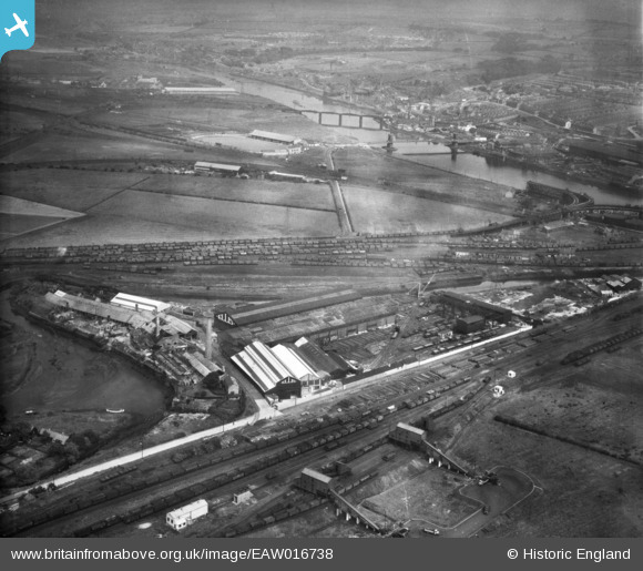
EAW016738 ENGLAND (1948). The Hannington (Ellis) Works at Derwent Haugh, Swalwell, from the south-east, 1948. This image was marked by Aerofilms Ltd for photo editing.
© Copyright OpenStreetMap contributors and licensed by the OpenStreetMap Foundation. 2025. Cartography is licensed as CC BY-SA.
Nearby Images (12)
Details
| Title | [EAW016738] The Hannington (Ellis) Works at Derwent Haugh, Swalwell, from the south-east, 1948. This image was marked by Aerofilms Ltd for photo editing. |
| Reference | EAW016738 |
| Date | 24-June-1948 |
| Link | |
| Place name | SWALWELL |
| Parish | |
| District | |
| Country | ENGLAND |
| Easting / Northing | 420445, 562781 |
| Longitude / Latitude | -1.6806824446697, 54.959168594711 |
| National Grid Reference | NZ204628 |
Pins

redmist |
Sunday 17th of November 2019 10:02:24 AM | |

redmist |
Sunday 17th of November 2019 10:00:22 AM | |

redmist |
Sunday 17th of November 2019 09:59:19 AM | |

gerry-r |
Sunday 22nd of June 2014 12:50:20 PM |


![[EAW016738] The Hannington (Ellis) Works at Derwent Haugh, Swalwell, from the south-east, 1948. This image was marked by Aerofilms Ltd for photo editing.](http://britainfromabove.org.uk/sites/all/libraries/aerofilms-images/public/100x100/EAW/016/EAW016738.jpg)
![[EAW016736] The Hannington (Ellis) Works at Derwent Haugh, Swalwell, from the south, 1948. This image was marked by Aerofilms Ltd for photo editing.](http://britainfromabove.org.uk/sites/all/libraries/aerofilms-images/public/100x100/EAW/016/EAW016736.jpg)
![[EAW016734] The Hannington (Ellis) Works at Derwent Haugh, Swalwell, 1948. This image was marked by Aerofilms Ltd for photo editing.](http://britainfromabove.org.uk/sites/all/libraries/aerofilms-images/public/100x100/EAW/016/EAW016734.jpg)
![[EAW016741] The Hannington (Ellis) Works at Derwent Haugh, Swalwell, 1948. This image was marked by Aerofilms Ltd for photo editing.](http://britainfromabove.org.uk/sites/all/libraries/aerofilms-images/public/100x100/EAW/016/EAW016741.jpg)
![[EAW016740] The Hannington (Ellis) Works at Derwent Haugh, Swalwell, 1948. This image was marked by Aerofilms Ltd for photo editing.](http://britainfromabove.org.uk/sites/all/libraries/aerofilms-images/public/100x100/EAW/016/EAW016740.jpg)
![[EAW016737] The Hannington (Ellis) Works at Derwent Haugh, Swalwell, from the south-east, 1948. This image was marked by Aerofilms Ltd for photo editing.](http://britainfromabove.org.uk/sites/all/libraries/aerofilms-images/public/100x100/EAW/016/EAW016737.jpg)
![[EAW016732] The Hannington (Ellis) Works at Derwent Haugh, Swalwell, 1948. This image was marked by Aerofilms Ltd for photo editing.](http://britainfromabove.org.uk/sites/all/libraries/aerofilms-images/public/100x100/EAW/016/EAW016732.jpg)
![[EAW016735] The Hannington (Ellis) Works at Derwent Haugh, Blaydon, 1948. This image was marked by Aerofilms Ltd for photo editing.](http://britainfromabove.org.uk/sites/all/libraries/aerofilms-images/public/100x100/EAW/016/EAW016735.jpg)
![[EAW033908] The Hurrocks Allotments Gardens, Hannington Works and environs, Blaydon, 1950. This image has been produced from a damaged negative.](http://britainfromabove.org.uk/sites/all/libraries/aerofilms-images/public/100x100/EAW/033/EAW033908.jpg)
![[EAW033903] The Hannington Works, Derwent Gut and environs, Blaydon, 1950](http://britainfromabove.org.uk/sites/all/libraries/aerofilms-images/public/100x100/EAW/033/EAW033903.jpg)
![[EAW016739] The Hannington (Ellis) Works at Derwent Haugh and adjacent railway sidings, Blaydon, 1948](http://britainfromabove.org.uk/sites/all/libraries/aerofilms-images/public/100x100/EAW/016/EAW016739.jpg)
![[EPW043796] The Hurrocks Allotment Gardens, the River Derwent and environs, Blaydon, from the east, 1934](http://britainfromabove.org.uk/sites/all/libraries/aerofilms-images/public/100x100/EPW/043/EPW043796.jpg)