
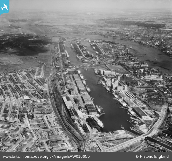
EAW016655 ENGLAND (1948). The Royal Docks, Canning Town, from the west, 1948
© Copyright OpenStreetMap contributors and licensed by the OpenStreetMap Foundation. 2026. Cartography is licensed as CC BY-SA.
Nearby Images (18)
EAW016655

EPW032933

EPW044120

EAW008819

EPW008889

EPR000001

EPW046150

EAW008826

EAW008816

EAW016656

EPW032934

EAW008820

EAW000053

EAW008823

EAW035765

EAW008822

EPW055308

EAW035969

Details
| Title | [EAW016655] The Royal Docks, Canning Town, from the west, 1948 |
| Reference | EAW016655 |
| Date | 17-June-1948 |
| Link | |
| Place name | CANNING TOWN |
| Parish | |
| District | |
| Country | ENGLAND |
| Easting / Northing | 540566, 180690 |
| Longitude / Latitude | 0.02568106172352, 51.507151519132 |
| National Grid Reference | TQ406807 |
Pins

26 clever road |
Tuesday 1st of April 2014 04:15:19 PM | |
Did you know the Krepka family. Lived at 15 Clever Road. John Krepka had 3 sons, Danny, John and Robert and I think they had a sister Margaret. Their mum was Irish if I remember rightly. John worked for Merchant Navy and there was a connection with Russia. I think sons may have joined M Navy as well. Probably talking about 50's to early 60's. |
woodfordsarah |
Sunday 9th of October 2016 02:08:29 PM |