
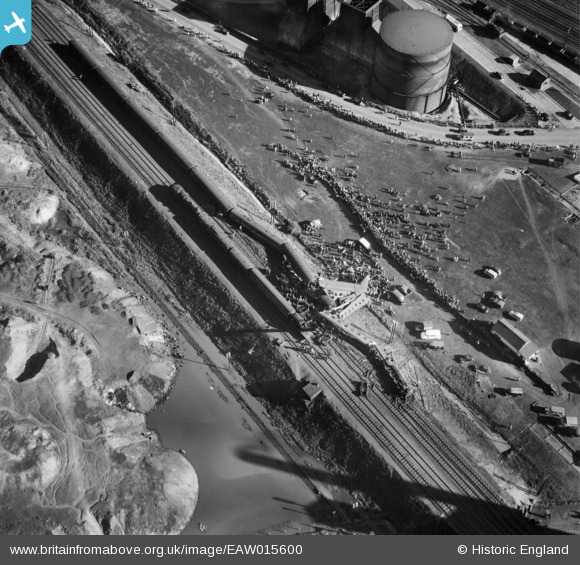
EAW015600 ENGLAND (1948). The Wath Road Junction Derailment, Wath Upon Dearne, 1948
© Copyright OpenStreetMap contributors and licensed by the OpenStreetMap Foundation. 2026. Cartography is licensed as CC BY-SA.
Nearby Images (12)
EAW015600

EAW016016

EAW015597

EAW016019

EAW015601

EAW015599

EAW016017

EAW016018

EAW016021

EAW015602

EAW016020
, Wath upon Dearne, 1948. This image has been produced from a damaged negative.")
EAW015598

Details
| Title | [EAW015600] The Wath Road Junction Derailment, Wath Upon Dearne, 1948 |
| Reference | EAW015600 |
| Date | 19-May-1948 |
| Link | |
| Place name | WATH UPON DEARNE |
| Parish | |
| District | |
| Country | ENGLAND |
| Easting / Northing | 445232, 400903 |
| Longitude / Latitude | -1.3179895433571, 53.502624007823 |
| National Grid Reference | SE452009 |
Pins

MB |
Saturday 25th of January 2014 10:50:29 AM | |
|
MB |
Saturday 25th of January 2014 10:48:08 AM | |
I assume this was LMS 5609, and that the pilot engine had been removed by the time this view was shot |
MB |
Saturday 25th of January 2014 10:49:27 AM |
User Comment Contributions
Full details of the accident can be gleaned from the official report that is available from here: http://www.railwaysarchive.co.uk/eventsummary.php?eventID=1413 |
Brightonboy |
Saturday 27th of February 2016 07:57:39 AM |