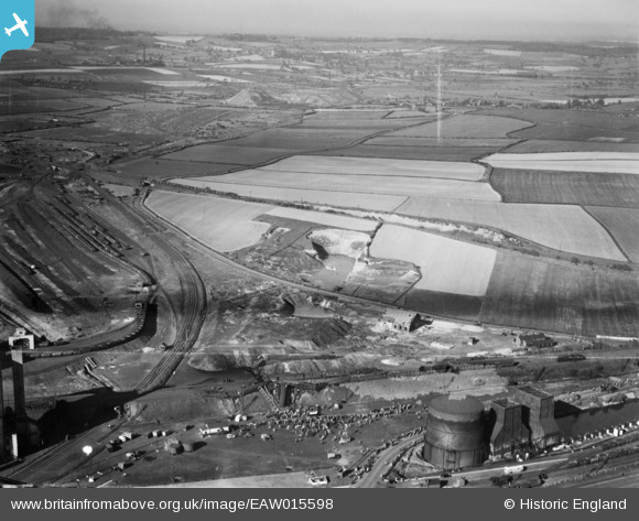
EAW015598 ENGLAND (1948). The Wath Road Junction Derailment, Wath Upon Dearne, from the south-west, 1948
© Copyright OpenStreetMap contributors and licensed by the OpenStreetMap Foundation. 2026. Cartography is licensed as CC BY-SA.
Nearby Images (12)
Details
| Title | [EAW015598] The Wath Road Junction Derailment, Wath Upon Dearne, from the south-west, 1948 |
| Reference | EAW015598 |
| Date | 19-May-1948 |
| Link | |
| Place name | WATH UPON DEARNE |
| Parish | |
| District | |
| Country | ENGLAND |
| Easting / Northing | 445396, 400847 |
| Longitude / Latitude | -1.3155250448197, 53.502106501739 |
| National Grid Reference | SE454008 |
Pins
User Comment Contributions
Full details of the accident can be gleaned from the official report that is available from here: http://www.railwaysarchive.co.uk/eventsummary.php?eventID=1413 |

Brightonboy |
Saturday 27th of February 2016 07:58:35 AM |


![[EAW015598] The Wath Road Junction Derailment, Wath Upon Dearne, from the south-west, 1948](http://britainfromabove.org.uk/sites/all/libraries/aerofilms-images/public/100x100/EAW/015/EAW015598.jpg)
![[EAW016020] The Wath Road Junction Derailment (site of), Wath upon Dearne, 1948. This image has been produced from a damaged negative.](http://britainfromabove.org.uk/sites/all/libraries/aerofilms-images/public/100x100/EAW/016/EAW016020.jpg)
![[EAW016017] The Wath Road Junction Derailment, Wath upon Dearne, 1948. This image has been produced from a print.](http://britainfromabove.org.uk/sites/all/libraries/aerofilms-images/public/100x100/EAW/016/EAW016017.jpg)
![[EAW015600] The Wath Road Junction Derailment, Wath Upon Dearne, 1948](http://britainfromabove.org.uk/sites/all/libraries/aerofilms-images/public/100x100/EAW/015/EAW015600.jpg)
![[EAW015602] The Wath Road Junction Derailment, Wath Upon Dearne, 1948](http://britainfromabove.org.uk/sites/all/libraries/aerofilms-images/public/100x100/EAW/015/EAW015602.jpg)
![[EAW016016] The Wath Road Junction Derailment, Wath upon Dearne, 1948. This image has been produced from a print.](http://britainfromabove.org.uk/sites/all/libraries/aerofilms-images/public/100x100/EAW/016/EAW016016.jpg)
![[EAW016021] The Wath Road Junction Derailment, Wath upon Dearne, 1948. This image has been produced from a print.](http://britainfromabove.org.uk/sites/all/libraries/aerofilms-images/public/100x100/EAW/016/EAW016021.jpg)
![[EAW015597] The Wath Road Junction Derailment, Wath Upon Dearne, 1948](http://britainfromabove.org.uk/sites/all/libraries/aerofilms-images/public/100x100/EAW/015/EAW015597.jpg)
![[EAW015599] The Wath Road Junction Derailment, Wath Upon Dearne, 1948](http://britainfromabove.org.uk/sites/all/libraries/aerofilms-images/public/100x100/EAW/015/EAW015599.jpg)
![[EAW016019] The Wath Road Junction Derailment, Wath upon Dearne, 1948. This image has been produced from a print.](http://britainfromabove.org.uk/sites/all/libraries/aerofilms-images/public/100x100/EAW/016/EAW016019.jpg)
![[EAW015601] The Wath Road Junction Derailment, Wath Upon Dearne, 1948](http://britainfromabove.org.uk/sites/all/libraries/aerofilms-images/public/100x100/EAW/015/EAW015601.jpg)
![[EAW016018] The Wath Road Junction Derailment, Wath upon Dearne, 1948. This image has been produced from a print.](http://britainfromabove.org.uk/sites/all/libraries/aerofilms-images/public/100x100/EAW/016/EAW016018.jpg)